Exploring Unstructured Environments using Minimal Sensing on Cooperative Nano-Drones

0
Sign in to get full access
Overview
- This paper explores the use of cooperative nano-drones to navigate and explore unstructured environments with minimal sensing capabilities.
- The researchers propose a novel approach that leverages swarm robotics and cooperative behavior to overcome the limitations of individual nano-drones.
- The system utilizes simple on-board sensors and inter-drone communication to collectively map and navigate through complex, unknown environments.
Plain English Explanation
The paper describes a system that uses a swarm of tiny drones, called nano-drones, to explore and navigate through unstructured environments. These environments may be cluttered, complex, or difficult for a single drone to navigate on its own.
The key idea is to have the nano-drones work together as a team, or swarm, to overcome the limitations of their individual sensing capabilities. Each nano-drone has only basic sensors, but by communicating and sharing information with each other, the swarm can build a collective understanding of the environment and plan a path through it.
The drones use simple sensors, like cameras and altimeters, to gather information about their surroundings. They then share this data with the other drones in the swarm, allowing the group to create a comprehensive map of the environment. This enables the swarm to navigate through the space, avoiding obstacles and finding the best routes, even in areas that would be challenging for a single drone.
This cooperative approach is important because nano-drones have very limited resources, such as battery life and computing power. By working together, they can achieve more than they could individually, making the system more robust and effective at exploring unknown environments.
Technical Explanation
The paper presents a novel approach for using cooperative nano-drones to navigate and explore unstructured environments. The researchers develop a system that leverages the collective behavior of a drone swarm to overcome the limitations of individual nano-drones' sensing capabilities.
The key technical components of the system include:
- Minimal On-board Sensing: Each nano-drone is equipped with only basic sensors, such as cameras and altimeters, to keep the platform lightweight and energy-efficient.
- Inter-drone Communication: The nano-drones communicate with each other to share sensor data and collaborate on mapping and navigation tasks.
- Decentralized Swarm Coordination: The system uses a decentralized, swarm-based approach to coordinate the drones' movements and decision-making, without relying on a central controller.
- Collective Mapping and Navigation: By combining the sensor data from multiple drones, the swarm can collectively build a comprehensive map of the environment and plan optimal navigation paths.
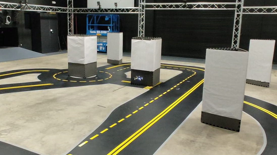
The researchers evaluate their approach through simulations and real-world experiments, demonstrating the system's ability to effectively explore and navigate through complex, unstructured environments using only minimal on-board sensing.
Critical Analysis
The paper presents a promising approach to using cooperative nano-drones for exploring unknown environments, but it also acknowledges several limitations and areas for further research:
- The current system relies on the drones' ability to maintain reliable communication links, which may be challenging in real-world environments with interference or obstructions.
- The performance of the collective mapping and navigation algorithms may degrade in larger-scale swarms or more complex environments, requiring further optimization and scalability testing.
- The paper does not address the potential safety and security concerns associated with the use of autonomous drone swarms, such as collision avoidance, hacking vulnerabilities, and potential misuse.
- Additional research is needed to evaluate the robustness and adaptability of the system in the face of dynamic environmental changes or adversarial interference.
Overall, the work presented in this paper represents an important step forward in the field of cooperative drone systems and their application to exploring unstructured environments. However, further development and thorough testing will be necessary to address the identified limitations and ensure the system's viability in real-world scenarios.
Conclusion
This paper introduces a novel approach for using cooperative nano-drones to navigate and explore unstructured environments with minimal sensing capabilities. By leveraging the collective behavior and communication of a drone swarm, the system is able to overcome the limitations of individual nano-drones and effectively map and navigate through complex, unknown spaces.
The key innovations of this work include the use of simple on-board sensors, decentralized swarm coordination, and collaborative mapping and navigation algorithms. While the paper highlights several areas for further research and improvement, the proposed system represents a significant advancement in the field of cooperative robotics and its potential applications in various domains, such as search and rescue, environmental monitoring, and infrastructure inspection.
This summary was produced with help from an AI and may contain inaccuracies - check out the links to read the original source documents!
Related Papers
0
Exploring Unstructured Environments using Minimal Sensing on Cooperative Nano-Drones
Pedro Arias-Perez, Alvika Gautam, Miguel Fernandez-Cortizas, David Perez-Saura, Srikanth Saripalli, Pascual Campoy
Recent advances have improved autonomous navigation and mapping under payload constraints, but current multi-robot inspection algorithms are unsuitable for nano-drones due to their need for heavy sensors and high computational resources. To address these challenges, we introduce ExploreBug, a novel hybrid frontier range bug algorithm designed to handle limited sensing capabilities for a swarm of nano-drones. This system includes three primary components: a mapping subsystem, an exploration subsystem, and a navigation subsystem. Additionally, an intra-swarm collision avoidance system is integrated to prevent collisions between drones. We validate the efficacy of our approach through extensive simulations and real-world exploration experiments involving up to seven drones in simulations and three in real-world settings, across various obstacle configurations and with a maximum navigation speed of 0.75 m/s. Our tests demonstrate that the algorithm efficiently completes exploration tasks, even with minimal sensing, across different swarm sizes and obstacle densities. Furthermore, our frontier allocation heuristic ensures an equal distribution of explored areas and paths traveled by each drone in the swarm. We publicly release the source code of the proposed system to foster further developments in mapping and exploration using autonomous nano drones.
Read more7/10/2024
0
Cooperative Indoor Exploration Leveraging a Mixed-Size UAV Team with Heterogeneous Sensors
Michaela Cihl'av{r}ov'a, V'aclav Pritzl, Martin Saska
Heterogeneous teams of Unmanned Aerial Vehicles (UAVs) can enhance the exploration capabilities of aerial robots by exploiting different strengths and abilities of varying UAVs. This paper presents a novel method for exploring unknown indoor spaces with a team of UAVs of different sizes and sensory equipment. We propose a frontier-based exploration with two task allocation strategies: a greedy strategy that assigns Points of Interest (POIs) based on Euclidean distance and UAV priority and an optimization strategy that solves a minimum-cost flow problem. The proposed method utilizes the SphereMap algorithm to assess the accessibility of the POIs and generate paths that account for obstacle distances, including collision avoidance maneuvers among UAVs. The proposed approach was validated through simulation testing and real-world experiments that evaluated the method's performance on board the UAVs.
Read more7/15/2024

0
Under-Canopy Navigation using Aerial Lidar Maps
Lucas Carvalho de Lima, Nicholas Lawrance, Kasra Khosoussi, Paulo Borges, Michael Bruenig
Autonomous navigation in unstructured natural environments poses a significant challenge. In goal navigation tasks without prior information, the limited look-ahead of onboard sensors utilised by robots compromises path efficiency. We propose a novel approach that leverages an above-the-canopy aerial map for improved ground robot navigation. Our system utilises aerial lidar scans to create a 3D probabilistic occupancy map, uniquely incorporating the uncertainty in the aerial vehicle's trajectory for improved accuracy. Novel path planning cost functions are introduced, combining path length with obstruction risk estimated from the probabilistic map. The D-Star Lite algorithm then calculates an optimal (minimum-cost) path to the goal. This system also allows for dynamic replanning upon encountering unforeseen obstacles on the ground. Extensive experiments and ablation studies in simulated and real forests demonstrate the effectiveness of our system.
Read more6/19/2024
👀
0
Ultra-Lightweight Collaborative Mapping for Robot Swarms
Vlad Niculescu, Tommaso Polonelli, Michele Magno, Luca Benini
A key requirement in robotics is the ability to simultaneously self-localize and map a previously unknown environment, relying primarily on onboard sensing and computation. Achieving fully onboard accurate simultaneous localization and mapping (SLAM) is feasible for high-end robotic platforms, whereas small and inexpensive robots face challenges due to constrained hardware, therefore frequently resorting to external infrastructure for sensing and computation. The challenge is further exacerbated in swarms of robots, where coordination, scalability, and latency are crucial concerns. This work introduces a decentralized and lightweight collaborative SLAM approach that enables mapping on virtually any robot, even those equipped with low-cost hardware and only 1.5 MB of memory, including miniaturized insect-size devices. Moreover, the proposed solution supports large swarm formations with the capability to coordinate hundreds of agents. To substantiate our claims, we have successfully implemented collaborative SLAM on centimeter-size drones weighing 46 g. Remarkably, we achieve a mapping accuracy below 30 cm, a result comparable to high-end state-of-the-art solutions while reducing the cost, memory, and computation requirements by two orders of magnitude. Our approach is innovative in three main aspects. First, it enables onboard infrastructure-less collaborative mapping with a lightweight and cost-effective ($20) solution in terms of sensing and computation. Second, we optimize the data traffic within the swarm to support hundreds of cooperative agents using standard wireless protocols such as ultra-wideband (UWB), Bluetooth, or WiFi. Last, we implement a distributed swarm coordination policy to decrease mapping latency and enhance accuracy.
Read more8/28/2024