Get Your Embedding Space in Order: Domain-Adaptive Regression for Forest Monitoring

0

Sign in to get full access
Overview
• This paper presents a domain-adaptive regression approach for forest monitoring using remote sensing data. • The method aims to address the challenge of domain shift, where models trained on one dataset perform poorly on other datasets due to differences in sensor, environmental, or geographic factors. • The proposed approach leverages contrastive learning to align the embedding spaces of different datasets, enabling more accurate regression models for predicting forest attributes like biomass or canopy height.
Plain English Explanation
The paper looks at a problem that often comes up when using machine learning for remote sensing tasks like monitoring forests. The issue is that models trained on one set of data (e.g., satellite images from a specific sensor) may not work well on a different set of data (e.g., images from a different sensor or location). This is known as the "domain shift" problem.
To address this, the researchers developed a new technique that uses "contrastive learning" to better align the feature representations (or "embedding spaces") of the different datasets. This helps the model learn a more generalizable set of features that can work across multiple datasets, rather than just memorizing patterns in the original training data.
The key idea is to train the model not just to predict the forest attributes (like biomass or tree height) accurately, but also to make the feature representations of different datasets more similar to each other. This allows the model to generalize better and make accurate predictions on new datasets it hasn't seen before.
The paper demonstrates the effectiveness of this approach through experiments on several remote sensing datasets for forest monitoring, showing improved performance compared to standard regression models that don't address the domain shift problem.
Technical Explanation
The paper proposes a domain-adaptive regression framework for forest monitoring using remote sensing data. To address the challenge of domain shift, where models trained on one dataset perform poorly on other datasets, the approach leverages contrastive learning to align the embedding spaces of different datasets.
Specifically, the model is trained to not only predict the target forest attribute (e.g., biomass, canopy height) accurately, but also to minimize the distance between feature representations of samples from different datasets in the learned embedding space. This encourages the model to learn a more generalizable set of features that can work across multiple domains.
The paper evaluates the proposed approach on several remote sensing datasets for forest monitoring, including link to "Frequency Decomposition-Driven Unsupervised Domain Adaptation for Remote Sensing" and link to "Single Domain Generalization for Crowd Counting". The results show that the domain-adaptive regression model outperforms standard regression models that do not explicitly address the domain shift problem.
Critical Analysis
The paper makes a valuable contribution by addressing the important challenge of domain shift in remote sensing applications for forest monitoring. The proposed contrastive learning-based approach is a well-designed solution that leverages recent advances in representation learning to improve the generalization of regression models across different datasets.
One potential limitation of the work is that it relies on the availability of labeled data from multiple domains for training. In some real-world scenarios, obtaining labeled data from diverse sources may be difficult or costly. The paper could be strengthened by exploring link to "Domain Rectifying Adapter for Cross-Domain Few-Shot Learning" or other techniques to address the case of limited labeled data in target domains.
Additionally, the paper could benefit from a more thorough discussion of potential biases or errors that may arise in the remote sensing data itself, and how those might impact the performance and reliability of the proposed regression models. Link to "Vision Transformers for Domain Adaptation and Generalization: A Study on Robustness" could provide relevant insights on this aspect.
Overall, the paper represents a valuable contribution to the field of remote sensing and forest monitoring, and the proposed domain-adaptive regression approach could have significant practical implications for improving the accuracy and robustness of forest attribute prediction models.
Conclusion
This paper introduces a domain-adaptive regression framework for forest monitoring using remote sensing data. By leveraging contrastive learning to align the embedding spaces of different datasets, the proposed approach can effectively address the challenge of domain shift and improve the generalization of regression models across diverse data sources.
The technical evaluation on several remote sensing datasets demonstrates the effectiveness of the method, outperforming standard regression models that do not explicitly account for domain differences. While the approach relies on the availability of labeled data from multiple domains, it represents an important step forward in developing more robust and reliable forest monitoring models that can be deployed across a variety of real-world scenarios.
This summary was produced with help from an AI and may contain inaccuracies - check out the links to read the original source documents!
Related Papers
0
Get Your Embedding Space in Order: Domain-Adaptive Regression for Forest Monitoring
Sizhuo Li, Dimitri Gominski, Martin Brandt, Xiaoye Tong, Philippe Ciais
Image-level regression is an important task in Earth observation, where visual domain and label shifts are a core challenge hampering generalization. However, cross-domain regression within remote sensing data remains understudied due to the absence of suited datasets. We introduce a new dataset with aerial and satellite imagery in five countries with three forest-related regression tasks. To match real-world applicative interests, we compare methods through a restrictive setup where no prior on the target domain is available during training, and models are adapted with limited information during testing. Building on the assumption that ordered relationships generalize better, we propose manifold diffusion for regression as a strong baseline for transduction in low-data regimes. Our comparison highlights the comparative advantages of inductive and transductive methods in cross-domain regression.
Read more8/16/2024
0
Remote Diffusion
Kunal Sunil Kasodekar
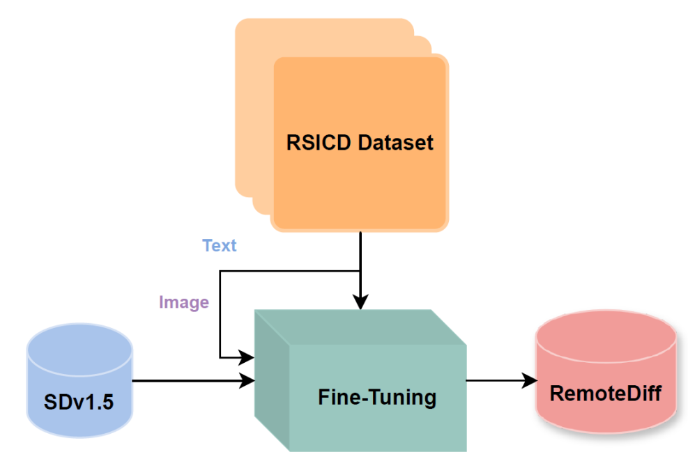
I explored adapting Stable Diffusion v1.5 for generating domain-specific satellite and aerial images in remote sensing. Recognizing the limitations of existing models like Midjourney and Stable Diffusion, trained primarily on natural RGB images and lacking context for remote sensing, I used the RSICD dataset to train a Stable Diffusion model with a loss of 0.2. I incorporated descriptive captions from the dataset for text-conditioning. Additionally, I created a synthetic dataset for a Land Use Land Classification (LULC) task, employing prompting techniques with RAG and ChatGPT and fine-tuning a specialized remote sensing LLM. However, I faced challenges with prompt quality and model performance. I trained a classification model (ResNet18) on the synthetic dataset achieving 49.48% test accuracy in TorchGeo to create a baseline. Quantitative evaluation through FID scores and qualitative feedback from domain experts assessed the realism and quality of the generated images and dataset. Despite extensive fine-tuning and dataset iterations, results indicated subpar image quality and realism, as indicated by high FID scores and domain-expert evaluation. These findings call attention to the potential of diffusion models in remote sensing while highlighting significant challenges related to insufficient pretraining data and computational resources.
Read more5/9/2024
🖼️
0
AdaTreeFormer: Few Shot Domain Adaptation for Tree Counting from a Single High-Resolution Image
Hamed Amini Amirkolaee, Miaojing Shi, Lianghua He, Mark Mulligan
The process of estimating and counting tree density using only a single aerial or satellite image is a difficult task in the fields of photogrammetry and remote sensing. However, it plays a crucial role in the management of forests. The huge variety of trees in varied topography severely hinders tree counting models to perform well. The purpose of this paper is to propose a framework that is learnt from the source domain with sufficient labeled trees and is adapted to the target domain with only a limited number of labeled trees. Our method, termed as AdaTreeFormer, contains one shared encoder with a hierarchical feature extraction scheme to extract robust features from the source and target domains. It also consists of three subnets: two for extracting self-domain attention maps from source and target domains respectively and one for extracting cross-domain attention maps. For the latter, an attention-to-adapt mechanism is introduced to distill relevant information from different domains while generating tree density maps; a hierarchical cross-domain feature alignment scheme is proposed that progressively aligns the features from the source and target domains. We also adopt adversarial learning into the framework to further reduce the gap between source and target domains. Our AdaTreeFormer is evaluated on six designed domain adaptation tasks using three tree counting datasets, ie Jiangsu, Yosemite, and London. Experimental results show that AdaTreeFormer significantly surpasses the state of the art, eg in the cross domain from the Yosemite to Jiangsu dataset, it achieves a reduction of 15.9 points in terms of the absolute counting errors and an increase of 10.8% in the accuracy of the detected trees' locations. The codes and datasets are available at https://github.com/HAAClassic/AdaTreeFormer.
Read more7/2/2024

0
Exploring selective image matching methods for zero-shot and few-sample unsupervised domain adaptation of urban canopy prediction
John Francis, Stephen Law
We explore simple methods for adapting a trained multi-task UNet which predicts canopy cover and height to a new geographic setting using remotely sensed data without the need of training a domain-adaptive classifier and extensive fine-tuning. Extending previous research, we followed a selective alignment process to identify similar images in the two geographical domains and then tested an array of data-based unsupervised domain adaptation approaches in a zero-shot setting as well as with a small amount of fine-tuning. We find that the selective aligned data-based image matching methods produce promising results in a zero-shot setting, and even more so with a small amount of fine-tuning. These methods outperform both an untransformed baseline and a popular data-based image-to-image translation model. The best performing methods were pixel distribution adaptation and fourier domain adaptation on the canopy cover and height tasks respectively.
Read more4/17/2024