ProGEO: Generating Prompts through Image-Text Contrastive Learning for Visual Geo-localization
2406.01906
0
0

Abstract
Visual Geo-localization (VG) refers to the process to identify the location described in query images, which is widely applied in robotics field and computer vision tasks, such as autonomous driving, metaverse, augmented reality, and SLAM. In fine-grained images lacking specific text descriptions, directly applying pure visual methods to represent neighborhood features often leads to the model focusing on overly fine-grained features, unable to fully mine the semantic information in the images. Therefore, we propose a two-stage training method to enhance visual performance and use contrastive learning to mine challenging samples. We first leverage the multi-modal description capability of CLIP (Contrastive Language-Image Pretraining) to create a set of learnable text prompts for each geographic image feature to form vague descriptions. Then, by utilizing dynamic text prompts to assist the training of the image encoder, we enable the image encoder to learn better and more generalizable visual features. This strategy of applying text to purely visual tasks addresses the challenge of using multi-modal models for geographic images, which often suffer from a lack of precise descriptions, making them difficult to utilize widely. We validate the effectiveness of the proposed strategy on several large-scale visual geo-localization datasets, and our method achieves competitive results on multiple visual geo-localization datasets. Our code and model are available at https://github.com/Chain-Mao/ProGEO.
Create account to get full access
Overview
• This paper introduces ProGEO, a method for generating text prompts through image-text contrastive learning to improve visual geo-localization models.
• ProGEO leverages a two-stage training process to learn text prompts that capture the rich visual and spatial information in images, which can then be used to guide VIP-LLAVA and other large language models for improved geo-localization.
• The approach outperforms existing methods on several benchmarks, including SatCLIP and LLMGeo, demonstrating the effectiveness of learned text prompts for visual geo-localization.
Plain English Explanation
The paper proposes a new method called ProGEO that generates text prompts to help AI models better understand the location information in images. This is important for tasks like geo-localization, where the goal is to determine the geographic location of an image.
ProGEO uses a two-stage training process. First, it learns to create text prompts that capture the visual and spatial details in images through a technique called "image-text contrastive learning." These prompts are designed to provide informative guidance to large language models like VIP-LLAVA, helping them better understand the geo-location information in the image.
In the second stage, the model is trained to use these learned prompts to improve its performance on geo-localization tasks. The paper shows that ProGEO outperforms existing methods on several benchmark datasets, including SatCLIP and LLMGeo. This demonstrates the value of using tailored text prompts to guide large language models for visual geo-localization.
Technical Explanation
The paper proposes a novel method called ProGEO (Prompt Generation through Contrastive Learning) that learns to generate informative text prompts to guide large language models for visual geo-localization. The key idea is to leverage image-text contrastive learning to capture the rich visual and spatial information in images, which can then be used to generate prompts that help models like VIP-LLAVA understand the geo-location of an image.
The ProGEO framework consists of two stages. In the first stage, the model is trained to generate text prompts that are contrastive with respect to image-text pairs, ensuring the prompts capture relevant visual and spatial cues. This is achieved by optimizing a contrastive loss function that encourages the generated prompts to be similar to the ground-truth text descriptions for the same image, while being dissimilar to descriptions of other images.
In the second stage, the pre-trained prompt generator is used to provide guidance to a geo-localization model, which is then fine-tuned on the target task. The authors demonstrate that this two-stage training approach outperforms existing methods on several benchmarks, including SatCLIP and LLMGeo, as well as the Joint Visual-Text Prompting approach.
Critical Analysis
The paper presents a promising approach for improving visual geo-localization by generating informative text prompts through image-text contrastive learning. However, the authors acknowledge that the current ProGEO model is limited to generating single-sentence prompts, and there may be opportunities to explore more complex prompt structures or even generative models for prompt creation.
Additionally, while the paper demonstrates the effectiveness of ProGEO on several benchmark datasets, it would be valuable to evaluate the approach on a wider range of real-world scenarios, especially in more challenging environments or with diverse image modalities, such as PIGEON for aerial imagery.
Furthermore, the paper does not provide a detailed analysis of the types of prompts generated by ProGEO or the specific visual and spatial cues they capture. A deeper investigation into the properties and characteristics of the learned prompts could provide valuable insights into the strengths and limitations of the approach.
Conclusion
The ProGEO method presented in this paper offers a promising approach for improving visual geo-localization by generating informative text prompts through image-text contrastive learning. By leveraging these prompts to guide large language models like VIP-LLAVA, the authors demonstrate significant performance improvements on several benchmark datasets.
The research highlights the potential of using tailored text prompts to enhance the understanding of visual and spatial information in multimodal AI systems. As the field of visual geo-localization continues to evolve, the ProGEO framework and its extensions could contribute to the development of more accurate and robust location-aware models, with applications in areas such as navigation, urban planning, and disaster response.
This summary was produced with help from an AI and may contain inaccuracies - check out the links to read the original source documents!
Related Papers
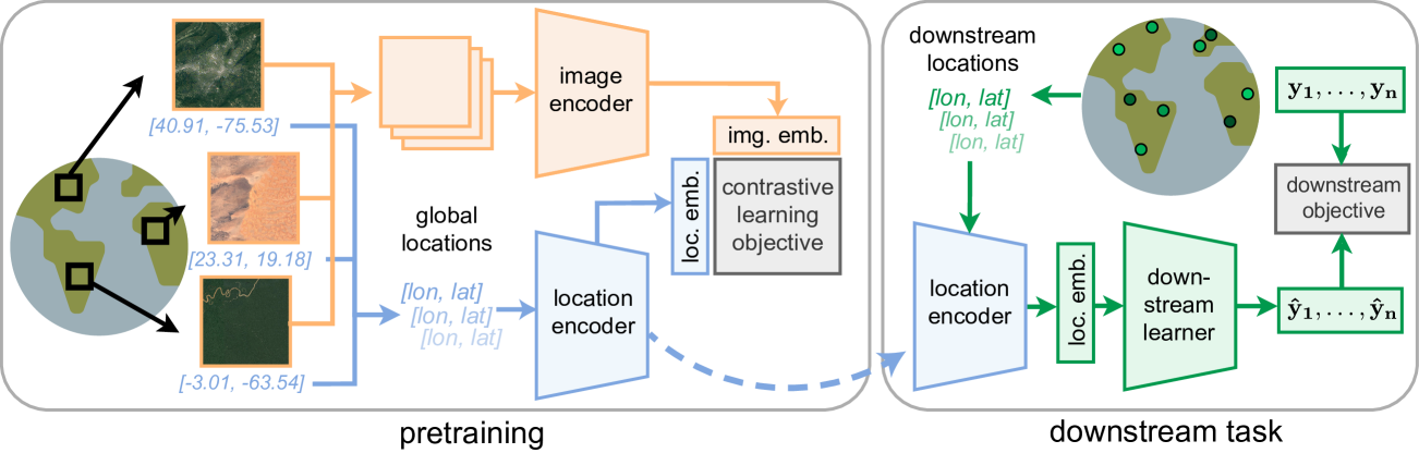
SatCLIP: Global, General-Purpose Location Embeddings with Satellite Imagery
Konstantin Klemmer, Esther Rolf, Caleb Robinson, Lester Mackey, Marc Ru{ss}wurm
0
0
Geographic information is essential for modeling tasks in fields ranging from ecology to epidemiology. However, extracting relevant location characteristics for a given task can be challenging, often requiring expensive data fusion or distillation from massive global imagery datasets. To address this challenge, we introduce Satellite Contrastive Location-Image Pretraining (SatCLIP). This global, general-purpose geographic location encoder learns an implicit representation of locations by matching CNN and ViT inferred visual patterns of openly available satellite imagery with their geographic coordinates. The resulting SatCLIP location encoder efficiently summarizes the characteristics of any given location for convenient use in downstream tasks. In our experiments, we use SatCLIP embeddings to improve prediction performance on nine diverse location-dependent tasks including temperature prediction, animal recognition, and population density estimation. Across tasks, SatCLIP consistently outperforms alternative location encoders and improves geographic generalization by encoding visual similarities of spatially distant environments. These results demonstrate the potential of vision-location models to learn meaningful representations of our planet from the vast, varied, and largely untapped modalities of geospatial data.
4/16/2024
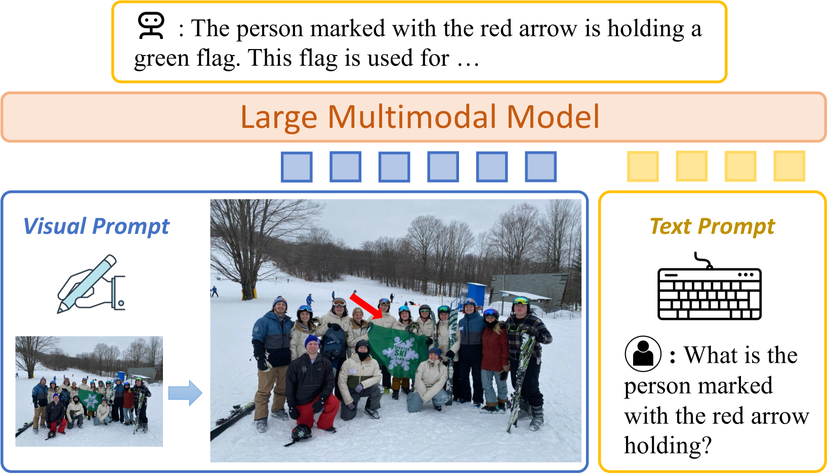
ViP-LLaVA: Making Large Multimodal Models Understand Arbitrary Visual Prompts
Mu Cai, Haotian Liu, Dennis Park, Siva Karthik Mustikovela, Gregory P. Meyer, Yuning Chai, Yong Jae Lee
0
0
While existing large vision-language multimodal models focus on whole image understanding, there is a prominent gap in achieving region-specific comprehension. Current approaches that use textual coordinates or spatial encodings often fail to provide a user-friendly interface for visual prompting. To address this challenge, we introduce a novel multimodal model capable of decoding arbitrary visual prompts. This allows users to intuitively mark images and interact with the model using natural cues like a red bounding box or pointed arrow. Our simple design directly overlays visual markers onto the RGB image, eliminating the need for complex region encodings, yet achieves state-of-the-art performance on region-understanding tasks like Visual7W, PointQA, and Visual Commonsense Reasoning benchmark. Furthermore, we present ViP-Bench, a comprehensive benchmark to assess the capability of models in understanding visual prompts across multiple dimensions, enabling future research in this domain. Code, data, and model are publicly available.
4/30/2024
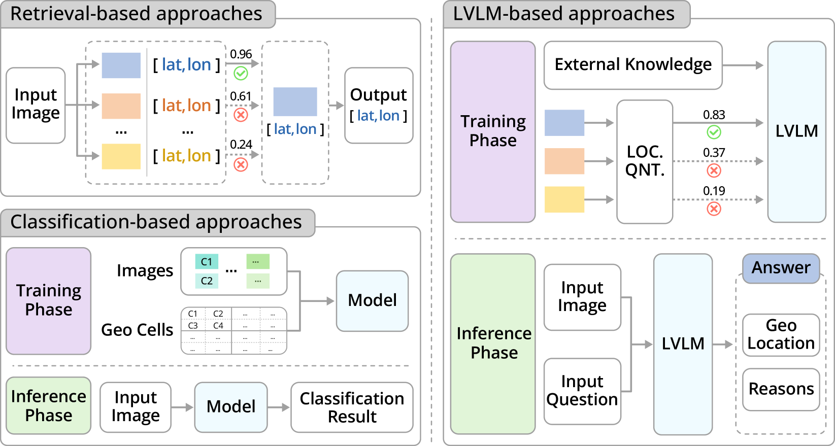
GeoReasoner: Geo-localization with Reasoning in Street Views using a Large Vision-Language Model
Ling Li, Yu Ye, Bingchuan Jiang, Wei Zeng
0
0
This work tackles the problem of geo-localization with a new paradigm using a large vision-language model (LVLM) augmented with human inference knowledge. A primary challenge here is the scarcity of data for training the LVLM - existing street-view datasets often contain numerous low-quality images lacking visual clues, and lack any reasoning inference. To address the data-quality issue, we devise a CLIP-based network to quantify the degree of street-view images being locatable, leading to the creation of a new dataset comprising highly locatable street views. To enhance reasoning inference, we integrate external knowledge obtained from real geo-localization games, tapping into valuable human inference capabilities. The data are utilized to train GeoReasoner, which undergoes fine-tuning through dedicated reasoning and location-tuning stages. Qualitative and quantitative evaluations illustrate that GeoReasoner outperforms counterpart LVLMs by more than 25% at country-level and 38% at city-level geo-localization tasks, and surpasses StreetCLIP performance while requiring fewer training resources. The data and code are available at https://github.com/lingli1996/GeoReasoner.
6/28/2024
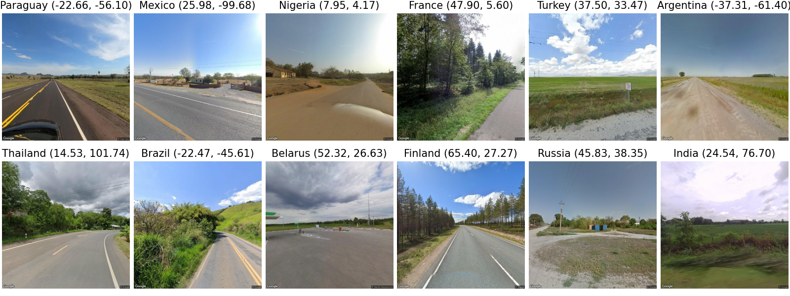
LLMGeo: Benchmarking Large Language Models on Image Geolocation In-the-wild
Zhiqiang Wang, Dejia Xu, Rana Muhammad Shahroz Khan, Yanbin Lin, Zhiwen Fan, Xingquan Zhu
0
0
Image geolocation is a critical task in various image-understanding applications. However, existing methods often fail when analyzing challenging, in-the-wild images. Inspired by the exceptional background knowledge of multimodal language models, we systematically evaluate their geolocation capabilities using a novel image dataset and a comprehensive evaluation framework. We first collect images from various countries via Google Street View. Then, we conduct training-free and training-based evaluations on closed-source and open-source multi-modal language models. we conduct both training-free and training-based evaluations on closed-source and open-source multimodal language models. Our findings indicate that closed-source models demonstrate superior geolocation abilities, while open-source models can achieve comparable performance through fine-tuning.
6/3/2024