SOLVR: Submap Oriented LiDAR-Visual Re-Localisation

0
Sign in to get full access
Overview
- SOLVR is a method for relocating a robot using both LiDAR and visual sensors.
- It builds submaps from sensor data and matches them to a global map to determine the robot's position.
- The key innovation is the use of a submap-based approach to fuse LiDAR and visual information.
Plain English Explanation
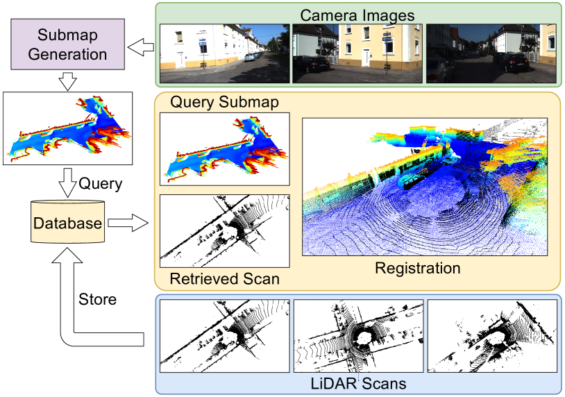
SOLVR: Submap Oriented LiDAR-Visual Re-Localisation presents a new technique for helping robots figure out where they are in their environment. Robots use sensors like LiDAR and cameras to build a map of their surroundings. SOLVR takes this sensor data and breaks it up into smaller "submaps." It then matches these submaps to a larger global map to determine the robot's precise location.
The main innovation in SOLVR is the way it combines information from both LiDAR and visual sensors. LiDAR provides detailed 3D information about the environment, while cameras give a more natural, 2D view. By fusing these two complementary data sources at the submap level, SOLVR can relocate the robot more accurately than using either sensor alone.
This submap-based approach makes SOLVR robust to changes in the environment over time, as it can match submaps to the global map even as individual features change. It also allows SOLVR to operate efficiently, as it only needs to process and match the relevant submaps rather than the entire map.
Technical Explanation
SOLVR is a method for robot re-localization that fuses data from LiDAR and visual sensors. It operates by first building submaps from the sensor data and then matching those submaps to a global map to determine the robot's pose.
The key steps in the SOLVR process are:
- Submap construction: The robot's sensor data is segmented into smaller submaps representing local regions of the environment.
- Submap description: Each submap is encoded using a combination of LiDAR and visual features to create a compact, discriminative descriptor.
- Global map matching: The submap descriptors are matched against a pre-built global map to find the best correspondences and estimate the robot's 6DoF pose.
The innovation in SOLVR is the use of this submap-based fusion of LiDAR and visual information. By operating at the submap level, SOLVR can handle changes in the environment over time and perform efficient re-localization. The authors demonstrate through experiments that this submap-centric approach outperforms methods that use global maps or fuse sensor data at the feature level.
Critical Analysis
The SOLVR paper presents a novel and promising approach to the problem of robot re-localization. The submap-based fusion of LiDAR and visual data is a clever way to leverage the strengths of both sensor modalities.
However, the paper does not address some potential limitations of the SOLVR method. For example, the performance of the submap matching process could degrade in highly dynamic or featureless environments where stable landmarks are scarce. Additionally, the computational cost of building, encoding, and matching submaps may be non-trivial, especially for resource-constrained robot platforms.
Further research could explore ways to adapt the SOLVR approach to handle more challenging environments, optimize its efficiency, and rigorously benchmark it against other state-of-the-art re-localization methods. Incorporating additional sensor data sources, such as GPS or IMU, could also be an avenue for improving SOLVR's robustness and accuracy.
Overall, the SOLVR method represents an interesting and well-executed contribution to the field of robot localization, with significant potential for further development and real-world applications.
Conclusion
SOLVR: Submap Oriented LiDAR-Visual Re-Localisation presents a novel approach to robot re-localization that fuses data from LiDAR and visual sensors. By breaking the sensor data into submaps and matching these submaps to a global map, SOLVR can accurately determine a robot's pose while being robust to changes in the environment.
The key innovation of SOLVR is its submap-centric fusion of complementary sensor modalities, which allows it to outperform methods that use global maps or feature-level fusion. This technique has the potential to significantly improve the reliability and performance of robotic systems operating in complex, dynamic environments.
While the paper identifies some promising avenues for further development, SOLVR represents an important step forward in the field of robot localization and navigation. As robots continue to play an increasingly prominent role in our lives, advancements like SOLVR will be crucial for enabling them to navigate and operate safely and effectively.
This summary was produced with help from an AI and may contain inaccuracies - check out the links to read the original source documents!
Related Papers
0
SOLVR: Submap Oriented LiDAR-Visual Re-Localisation
Joshua Knights, Sebasti'an Barbas Laina, Peyman Moghadam, Stefan Leutenegger
This paper proposes SOLVR, a unified pipeline for learning based LiDAR-Visual re-localisation which performs place recognition and 6-DoF registration across sensor modalities. We propose a strategy to align the input sensor modalities by leveraging stereo image streams to produce metric depth predictions with pose information, followed by fusing multiple scene views from a local window using a probabilistic occupancy framework to expand the limited field-of-view of the camera. Additionally, SOLVR adopts a flexible definition of what constitutes positive examples for different training losses, allowing us to simultaneously optimise place recognition and registration performance. Furthermore, we replace RANSAC with a registration function that weights a simple least-squares fitting with the estimated inlier likelihood of sparse keypoint correspondences, improving performance in scenarios with a low inlier ratio between the query and retrieved place. Our experiments on the KITTI and KITTI360 datasets show that SOLVR achieves state-of-the-art performance for LiDAR-Visual place recognition and registration, particularly improving registration accuracy over larger distances between the query and retrieved place.
Read more9/17/2024

0
SALSA: Swift Adaptive Lightweight Self-Attention for Enhanced LiDAR Place Recognition
Raktim Gautam Goswami, Naman Patel, Prashanth Krishnamurthy, Farshad Khorrami
Large-scale LiDAR mappings and localization leverage place recognition techniques to mitigate odometry drifts, ensuring accurate mapping. These techniques utilize scene representations from LiDAR point clouds to identify previously visited sites within a database. Local descriptors, assigned to each point within a point cloud, are aggregated to form a scene representation for the point cloud. These descriptors are also used to re-rank the retrieved point clouds based on geometric fitness scores. We propose SALSA, a novel, lightweight, and efficient framework for LiDAR place recognition. It consists of a Sphereformer backbone that uses radial window attention to enable information aggregation for sparse distant points, an adaptive self-attention layer to pool local descriptors into tokens, and a multi-layer-perceptron Mixer layer for aggregating the tokens to generate a scene descriptor. The proposed framework outperforms existing methods on various LiDAR place recognition datasets in terms of both retrieval and metric localization while operating in real-time.
Read more7/31/2024
0
Narrowing your FOV with SOLiD: Spatially Organized and Lightweight Global Descriptor for FOV-constrained LiDAR Place Recognition
Hogyun Kim, Jiwon Choi, Taehu Sim, Giseop Kim, Younggun Cho
We often encounter limited FOV situations due to various factors such as sensor fusion or sensor mount in real-world robot navigation. However, the limited FOV interrupts the generation of descriptions and impacts place recognition adversely. Therefore, we suffer from correcting accumulated drift errors in a consistent map using LiDAR-based place recognition with limited FOV. Thus, in this paper, we propose a robust LiDAR-based place recognition method for handling narrow FOV scenarios. The proposed method establishes spatial organization based on the range-elevation bin and azimuth-elevation bin to represent places. In addition, we achieve a robust place description through reweighting based on vertical direction information. Based on these representations, our method enables addressing rotational changes and determining the initial heading. Additionally, we designed a lightweight and fast approach for the robot's onboard autonomy. For rigorous validation, the proposed method was tested across various LiDAR place recognition scenarios (i.e., single-session, multi-session, and multi-robot scenarios). To the best of our knowledge, we report the first method to cope with the restricted FOV. Our place description and SLAM codes will be released. Also, the supplementary materials of our descriptor are available at texttt{url{https://sites.google.com/view/lidar-solid}}.
Read more8/28/2024

0
Matched Filtering based LiDAR Place Recognition for Urban and Natural Environments
Therese Joseph, Tobias Fischer, Michael Milford
Place recognition is an important task within autonomous navigation, involving the re-identification of previously visited locations from an initial traverse. Unlike visual place recognition (VPR), LiDAR place recognition (LPR) is tolerant to changes in lighting, seasons, and textures, leading to high performance on benchmark datasets from structured urban environments. However, there is a growing need for methods that can operate in diverse environments with high performance and minimal training. In this paper, we propose a handcrafted matching strategy that performs roto-translation invariant place recognition and relative pose estimation for both urban and unstructured natural environments. Our approach constructs Birds Eye View (BEV) global descriptors and employs a two-stage search using matched filtering -- a signal processing technique for detecting known signals amidst noise. Extensive testing on the NCLT, Oxford Radar, and WildPlaces datasets consistently demonstrates state-of-the-art (SoTA) performance across place recognition and relative pose estimation metrics, with up to 15% higher recall than previous SoTA.
Read more9/9/2024