EvaNet: Elevation-Guided Flood Extent Mapping on Earth Imagery

0
Sign in to get full access
Overview
- This paper presents EvaNet, a novel approach for flood extent mapping using Earth imagery and elevation data.
- EvaNet leverages both visual and elevation information to accurately identify flooded areas, improving upon previous methods that relied solely on visual data.
- The model is evaluated on a large-scale flood dataset, demonstrating its superior performance compared to existing techniques.
Plain English Explanation
EvaNet is a new system that can map the extent of floods using satellite or aerial images of the Earth's surface. Previous methods for flood mapping have only used the visual information in the images, but EvaNet also incorporates elevation data to get a better understanding of the terrain.
By combining visual and elevation information, EvaNet is able to more accurately identify which areas are flooded. This is important for disaster response and recovery efforts, as having an accurate picture of the flood extent can help direct resources to the right places.
The researchers tested EvaNet on a large dataset of flood events and showed that it outperformed existing flood mapping techniques. This suggests EvaNet could be a valuable tool for monitoring and responding to floods around the world.
Technical Explanation
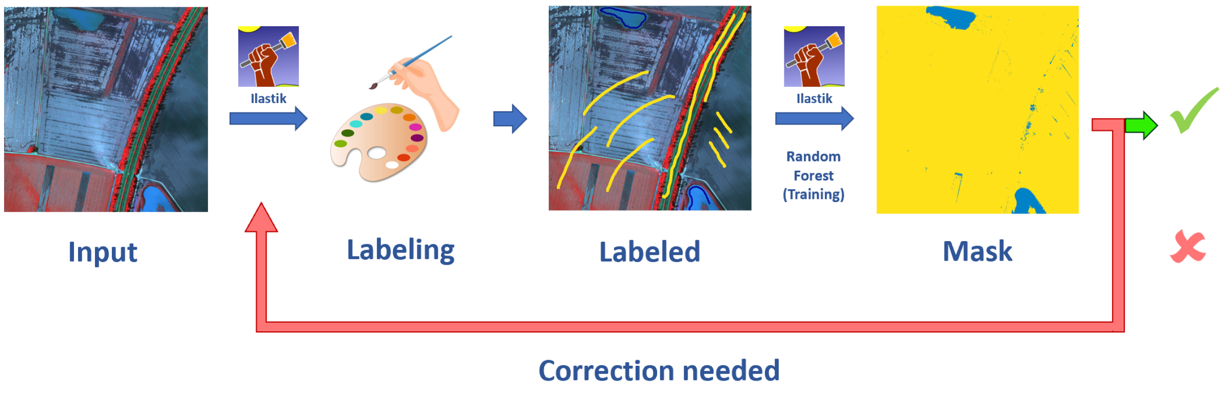
The key innovation of EvaNet is its use of both visual and elevation data to map flood extents. Previous methods have relied solely on the visual information in Earth imagery, but EvaNet also incorporates elevation data from sources like digital elevation models.
The EvaNet architecture consists of two main components: a vision encoder that processes the input imagery, and an elevation encoder that processes the elevation data. These encoders extract relevant features from the respective data sources, which are then combined and passed through a segmentation head to produce a flood extent map.
The researchers evaluate EvaNet on a large-scale flood dataset, comparing its performance to several baseline models that only use visual information. The results demonstrate that EvaNet significantly outperforms these baselines, highlighting the value of incorporating elevation data for this task.
Critical Analysis
The authors acknowledge some limitations of their approach, such as the reliance on high-quality elevation data, which may not be available in all regions. Additionally, EvaNet's performance may be affected by factors like image quality, cloud cover, and the specific characteristics of each flood event.
Further research could explore ways to make EvaNet more robust to these challenges, such as by incorporating additional data sources or developing more sophisticated fusion techniques. The authors also suggest exploring the use of EvaNet for other applications, such as building footprint extraction or urban mapping, where elevation data could provide valuable complementary information.
Conclusion
The EvaNet system represents an important advance in flood mapping by leveraging both visual and elevation data. Its strong performance on a large-scale flood dataset suggests it could be a valuable tool for disaster response and recovery efforts, helping to direct resources to the areas most affected by floods.
While EvaNet has some limitations, the authors have outlined promising directions for future research to address these challenges. Overall, the work demonstrates the potential of integrating multiple data sources, such as satellite imagery and elevation data, to tackle complex geospatial problems like flood analysis.
This summary was produced with help from an AI and may contain inaccuracies - check out the links to read the original source documents!
Related Papers
0
EvaNet: Elevation-Guided Flood Extent Mapping on Earth Imagery
Mirza Tanzim Sami, Da Yan, Saugat Adhikari, Lyuheng Yuan, Jiao Han, Zhe Jiang, Jalal Khalil, Yang Zhou
Accurate and timely mapping of flood extent from high-resolution satellite imagery plays a crucial role in disaster management such as damage assessment and relief activities. However, current state-of-the-art solutions are based on U-Net, which can-not segment the flood pixels accurately due to the ambiguous pixels (e.g., tree canopies, clouds) that prevent a direct judgement from only the spectral features. Thanks to the digital elevation model (DEM) data readily available from sources such as United States Geological Survey (USGS), this work explores the use of an elevation map to improve flood extent mapping. We propose, EvaNet, an elevation-guided segmentation model based on the encoder-decoder architecture with two novel techniques: (1) a loss function encoding the physical law of gravity that if a location is flooded (resp. dry), then its adjacent locations with a lower (resp. higher) elevation must also be flooded (resp. dry); (2) a new (de)convolution operation that integrates the elevation map by a location sensitive gating mechanism to regulate how much spectral features flow through adjacent layers. Extensive experiments show that EvaNet significantly outperforms the U-Net baselines, and works as a perfect drop-in replacement for U-Net in existing solutions to flood extent mapping.
Read more5/14/2024

0
Enabling Quick, Accurate Crowdsourced Annotation for Elevation-Aware Flood Extent Mapping
Landon Dyken, Saugat Adhikari, Pravin Poudel, Steve Petruzza, Da Yan, Will Usher, Sidharth Kumar
In order to assess damage and properly allocate relief efforts, mapping the extent of flood events is a necessary and important aspect of disaster management. In recent years, deep learning methods have evolved as an effective tool to quickly label high-resolution imagery and provide necessary flood extent mappings. These methods, though, require large amounts of annotated training data to create models that are accurate and robust to new flooded imagery. In this work, we provide FloodTrace, an application that enables effective crowdsourcing for flooded region annotation for machine learning training data, removing the requirement for annotation to be done solely by researchers. We accomplish this through two orthogonal methods within our application, informed by requirements from domain experts. First, we utilize elevation-guided annotation tools and 3D rendering to inform user annotation decisions with digital elevation model data, improving annotation accuracy. For this purpose, we provide a unique annotation method that uses topological data analysis to outperform the state-of-the-art elevation-guided annotation tool in efficiency. Second, we provide a framework for researchers to review aggregated crowdsourced annotations and correct inaccuracies using methods inspired by uncertainty visualization. We conducted a user study to confirm the application effectiveness in which 266 graduate students annotated high-resolution aerial imagery from Hurricane Matthew in North Carolina. Experimental results show the accuracy and efficiency benefits of our application apply even for untrained users. In addition, using our aggregation and correction framework, flood detection models trained on crowdsourced annotations were able to achieve performance equal to models trained on expert-labeled annotations, while requiring a fraction of the time on the part of the researcher.
Read more8/13/2024
0
BlessemFlood21: Advancing Flood Analysis with a High-Resolution Georeferenced Dataset for Humanitarian Aid Support
Vladyslav Polushko, Alexander Jenal, Jens Bongartz, Immanuel Weber, Damjan Hatic, Ronald Rosch, Thomas Marz, Markus Rauhut, Andreas Weinmann
Floods are an increasingly common global threat, causing emergencies and severe damage to infrastructure. During crises, organisations such as the World Food Programme use remotely sensed imagery, typically obtained through drones, for rapid situational analysis to plan life-saving actions. Computer Vision tools are needed to support task force experts on-site in the evaluation of the imagery to improve their efficiency and to allocate resources strategically. We introduce the BlessemFlood21 dataset to stimulate research on efficient flood detection tools. The imagery was acquired during the 2021 Erftstadt-Blessem flooding event and consists of high-resolution and georeferenced RGB-NIR images. In the resulting RGB dataset, the images are supplemented with detailed water masks, obtained via a semi-supervised human-in-the-loop technique, where in particular the NIR information is leveraged to classify pixels as either water or non-water. We evaluate our dataset by training and testing established Deep Learning models for semantic segmentation. With BlessemFlood21 we provide labeled high-resolution RGB data and a baseline for further development of algorithmic solutions tailored to flood detection in RGB imagery.
Read more7/9/2024
0
DeepDamageNet: A two-step deep-learning model for multi-disaster building damage segmentation and classification using satellite imagery
Irene Alisjahbana (Mullet), Jiawei Li (Mullet), Ben (Mullet), Strong, Yue Zhang
Satellite imagery has played an increasingly important role in post-disaster building damage assessment. Unfortunately, current methods still rely on manual visual interpretation, which is often time-consuming and can cause very low accuracy. To address the limitations of manual interpretation, there has been a significant increase in efforts to automate the process. We present a solution that performs the two most important tasks in building damage assessment, segmentation and classification, through deep-learning models. We show our results submitted as part of the xView2 Challenge, a competition to design better models for identifying buildings and their damage level after exposure to multiple kinds of natural disasters. Our best model couples a building identification semantic segmentation convolutional neural network (CNN) to a building damage classification CNN, with a combined F1 score of 0.66, surpassing the xView2 challenge baseline F1 score of 0.28. We find that though our model was able to identify buildings with relatively high accuracy, building damage classification across various disaster types is a difficult task due to the visual similarity between different damage levels and different damage distribution between disaster types, highlighting the fact that it may be important to have a probabilistic prior estimate regarding disaster damage in order to obtain accurate predictions.
Read more5/9/2024