Composed Image Retrieval for Remote Sensing
2405.15587
0
0

Abstract
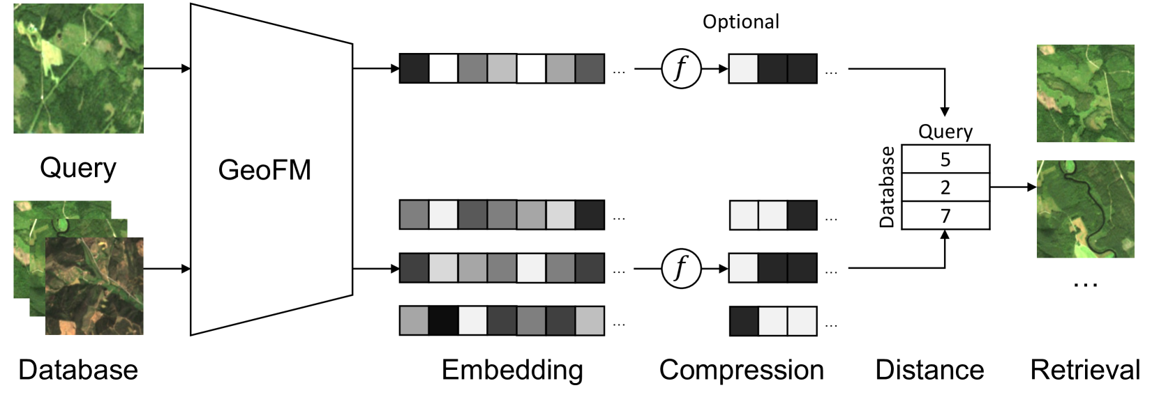
This work introduces composed image retrieval to remote sensing. It allows to query a large image archive by image examples alternated by a textual description, enriching the descriptive power over unimodal queries, either visual or textual. Various attributes can be modified by the textual part, such as shape, color, or context. A novel method fusing image-to-image and text-to-image similarity is introduced. We demonstrate that a vision-language model possesses sufficient descriptive power and no further learning step or training data are necessary. We present a new evaluation benchmark focused on color, context, density, existence, quantity, and shape modifications. Our work not only sets the state-of-the-art for this task, but also serves as a foundational step in addressing a gap in the field of remote sensing image retrieval. Code at: https://github.com/billpsomas/rscir
Create account to get full access
Overview
- Discusses a method for retrieving and composing relevant remote sensing images based on textual queries
- Introduces a novel "composed image retrieval" approach that can generate composite images by combining multiple retrieved images
- Demonstrates the effectiveness of the proposed method on several remote sensing image datasets
Plain English Explanation
The paper presents a new technique for searching and retrieving remote sensing images based on text-based queries. Traditional image retrieval methods often struggle when users want to find a specific combination of objects or features in an image. The proposed "composed image retrieval" approach addresses this by allowing users to describe what they're looking for in natural language, and the system will then generate a composite image by combining multiple relevant images.
For example, if a user searches for "a city with a river running through it and green hills in the background," the system would retrieve and stitch together individual images of a city, a river, and hills to create a new composite image that matches the textual description. This makes the image retrieval process more flexible and intuitive for users working with remote sensing data.
The paper demonstrates the effectiveness of this approach on several datasets of satellite and aerial imagery, showing that it can accurately generate relevant composite images in response to complex text-based queries. This could be especially useful for applications like urban planning, environmental monitoring, and disaster response, where being able to quickly find and combine specific image elements is crucial.
Technical Explanation
The core of the proposed method is a "Composed Image Retrieval" (CIR) framework that takes a textual query as input and generates a composite image by retrieving and fusing multiple individual images. The key components of this framework include:
- Text Encoder: A transformer-based language model that encodes the input text query into a semantic representation.
- Image Encoder: A convolutional neural network that encodes individual remote sensing images into a visual feature space.
- Retrieval Module: A cross-modal matching module that compares the text and image encodings to retrieve the most relevant individual images.
- Composition Module: A generative model that combines the retrieved individual images into a final composite image based on the input text query.
The authors evaluate the CIR framework on several remote sensing image datasets, including Knowledge-Aware Text-Image Retrieval for Remote Sensing, Multi-Spectral Remote Sensing Image Retrieval Using Dual-Branch Network, and Exploring Text-Guided Single Image Editing for Remote Sensing. They demonstrate that the CIR approach outperforms existing image retrieval and composition methods, especially for complex text queries that require combining multiple visual elements.
Critical Analysis
The authors present a compelling and technically sound approach for composed image retrieval in the context of remote sensing data. The ability to generate composite images based on textual descriptions is a valuable capability that can enhance the usability and accessibility of large remote sensing image archives.
One potential limitation of the approach is the reliance on pre-trained neural network models for encoding text and images. While the authors show strong performance on the evaluated datasets, the generalization of the CIR framework to new domains or data distributions may be dependent on the availability of large, annotated training datasets. Exploring few-shot or unsupervised adaptation techniques could help improve the flexibility and robustness of the method.
Additionally, the paper does not provide much insight into the interpretability or explainability of the composed image generation process. Understanding how the system selects and combines individual images to match the input text query could be important for building trust and enabling human oversight, especially in mission-critical applications like disaster response.
Overall, the proposed CIR framework represents an exciting advance in the field of Compressible, Searchable AI-Native Multi-Modal Retrieval and could have significant practical implications for remote sensing image analysis and exploration. Further research to address the limitations mentioned above could help strengthen the approach and expand its applicability.
Conclusion
This paper introduces a novel "Composed Image Retrieval" (CIR) framework that enables users to search for and generate composite remote sensing images based on textual descriptions. By combining a text encoder, image encoder, retrieval module, and composition module, the CIR system can accurately retrieve and fuse multiple individual images to match complex user queries.
The authors demonstrate the effectiveness of the CIR approach on several remote sensing image datasets, showcasing its potential to enhance the usability and accessibility of large image archives. This could be particularly valuable for applications like urban planning, environmental monitoring, and disaster response, where being able to quickly find and combine specific visual elements is crucial.
While the paper presents a technically sound solution, there are some potential limitations around model generalization and interpretability that could benefit from further research. Overall, the CIR framework represents an exciting advancement in Enhancing Interactive Image Retrieval through Query Rewriting Using and could have significant practical implications for the remote sensing community.
This summary was produced with help from an AI and may contain inaccuracies - check out the links to read the original source documents!
Related Papers

Towards a multimodal framework for remote sensing image change retrieval and captioning
Roger Ferrod, Luigi Di Caro, Dino Ienco
0
0
Recently, there has been increasing interest in multimodal applications that integrate text with other modalities, such as images, audio and video, to facilitate natural language interactions with multimodal AI systems. While applications involving standard modalities have been extensively explored, there is still a lack of investigation into specific data modalities such as remote sensing (RS) data. Despite the numerous potential applications of RS data, including environmental protection, disaster monitoring and land planning, available solutions are predominantly focused on specific tasks like classification, captioning and retrieval. These solutions often overlook the unique characteristics of RS data, such as its capability to systematically provide information on the same geographical areas over time. This ability enables continuous monitoring of changes in the underlying landscape. To address this gap, we propose a novel foundation model for bi-temporal RS image pairs, in the context of change detection analysis, leveraging Contrastive Learning and the LEVIR-CC dataset for both captioning and text-image retrieval. By jointly training a contrastive encoder and captioning decoder, our model add text-image retrieval capabilities, in the context of bi-temporal change detection, while maintaining captioning performances that are comparable to the state of the art. We release the source code and pretrained weights at: https://github.com/rogerferrod/RSICRC.
6/21/2024
✨
Knowledge-aware Text-Image Retrieval for Remote Sensing Images
Li Mi, Xianjie Dai, Javiera Castillo-Navarro, Devis Tuia
0
0
Image-based retrieval in large Earth observation archives is challenging because one needs to navigate across thousands of candidate matches only with the query image as a guide. By using text as information supporting the visual query, the retrieval system gains in usability, but at the same time faces difficulties due to the diversity of visual signals that cannot be summarized by a short caption only. For this reason, as a matching-based task, cross-modal text-image retrieval often suffers from information asymmetry between texts and images. To address this challenge, we propose a Knowledge-aware Text-Image Retrieval (KTIR) method for remote sensing images. By mining relevant information from an external knowledge graph, KTIR enriches the text scope available in the search query and alleviates the information gaps between texts and images for better matching. Moreover, by integrating domain-specific knowledge, KTIR also enhances the adaptation of pre-trained vision-language models to remote sensing applications. Experimental results on three commonly used remote sensing text-image retrieval benchmarks show that the proposed knowledge-aware method leads to varied and consistent retrievals, outperforming state-of-the-art retrieval methods.
5/7/2024
Multi-Spectral Remote Sensing Image Retrieval Using Geospatial Foundation Models
Benedikt Blumenstiel, Viktoria Moor, Romeo Kienzler, Thomas Brunschwiler
0
0
Image retrieval enables an efficient search through vast amounts of satellite imagery and returns similar images to a query. Deep learning models can identify images across various semantic concepts without the need for annotations. This work proposes to use Geospatial Foundation Models, like Prithvi, for remote sensing image retrieval with multiple benefits: i) the models encode multi-spectral satellite data and ii) generalize without further fine-tuning. We introduce two datasets to the retrieval task and observe a strong performance: Prithvi processes six bands and achieves a mean Average Precision of 97.62% on BigEarthNet-43 and 44.51% on ForestNet-12, outperforming other RGB-based models. Further, we evaluate three compression methods with binarized embeddings balancing retrieval speed and accuracy. They match the retrieval speed of much shorter hash codes while maintaining the same accuracy as floating-point embeddings but with a 32-fold compression. The code is available at https://github.com/IBM/remote-sensing-image-retrieval.
5/24/2024
🖼️
Exploring Text-Guided Single Image Editing for Remote Sensing Images
Fangzhou Han, Lingyu Si, Hongwei Dong, Lamei Zhang, Hao Chen, Bo Du
0
0
Artificial Intelligence Generative Content (AIGC) technologies have significantly influenced the remote sensing domain, particularly in the realm of image generation. However, remote sensing image editing, an equally vital research area, has not garnered sufficient attention. Different from text-guided editing in natural images, which relies on extensive text-image paired data for semantic correlation, the application scenarios of remote sensing image editing are often extreme, such as forest on fire, so it is difficult to obtain sufficient paired samples. At the same time, the lack of remote sensing semantics and the ambiguity of text also restrict the further application of image editing in remote sensing field. To solve above problems, this letter proposes a diffusion based method to fulfill stable and controllable remote sensing image editing with text guidance. Our method avoids the use of a large number of paired image, and can achieve good image editing results using only a single image. The quantitative evaluation system including CLIP score and subjective evaluation metrics shows that our method has better editing effect on remote sensing images than the existing image editing model.
5/10/2024