DeepAAT: Deep Automated Aerial Triangulation for Fast UAV-based Mapping

0
Sign in to get full access
Overview
- This paper introduces DeepAAT, a deep learning-based approach for Automated Aerial Triangulation (AAT) that enables fast and accurate mapping using Unmanned Aerial Vehicles (UAVs).
- AAT is a crucial step in photogrammetry and remote sensing, responsible for determining the position and orientation of aerial images, which is essential for creating 3D models and maps.
- The proposed DeepAAT framework leverages deep learning techniques to streamline the AAT process, making it more efficient and accessible for UAV-based mapping applications.
Plain English Explanation
The paper presents a new technique called DeepAAT that uses deep learning to help create maps and 3D models from aerial images captured by drones (also known as Unmanned Aerial Vehicles or UAVs). Traditionally, the process of Automated Aerial Triangulation (AAT) is a crucial but time-consuming step in this type of photogrammetry and remote sensing work. DeepAAT aims to make AAT faster and more accurate, allowing users to create high-quality maps and models more efficiently using their UAVs.
Technical Explanation
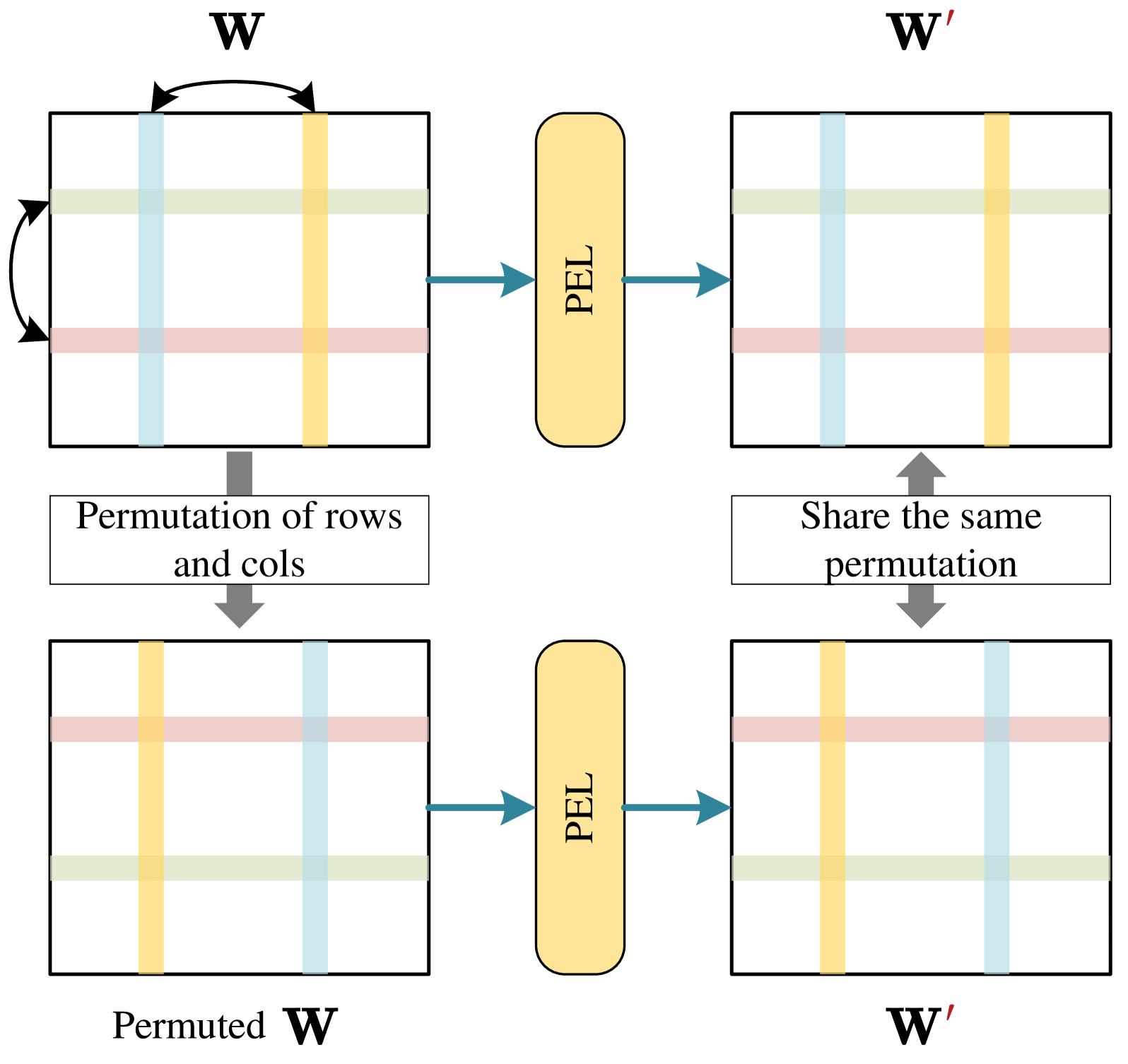
The DeepAAT framework leverages deep learning algorithms to automate the key steps of the AAT process. This includes:
- Feature Extraction: Deep learning models are used to detect and extract distinctive visual features from the aerial images.
- Bundle Adjustment: The extracted features are then used to determine the precise position and orientation of each image, a process known as bundle adjustment.
- Spatial Resectioning: The oriented images are spatially resectioned to create a unified, georeferenced coordinate system.
By automating these complex tasks, DeepAAT can significantly reduce the time and effort required to perform AAT, making it more accessible for UAV-based mapping applications. The paper demonstrates the effectiveness of DeepAAT through extensive experiments, comparing its performance to traditional AAT approaches.
Critical Analysis
The paper provides a comprehensive evaluation of the DeepAAT framework, highlighting its advantages over classic AAT methods. However, the authors acknowledge that the approach may still face some limitations, such as the need for a sufficient number of high-quality training images to achieve optimal performance.
Additionally, while DeepAAT shows promising results, the authors note that further research is needed to fully address the challenges of UAV-based mapping, such as handling varying environmental conditions, complex terrain, and diverse sensor configurations. Integrating DeepAAT with other advanced techniques, like those explored in DiffDet4SAR or FlightScope, could help expand its capabilities and robustness.
Conclusion
The DeepAAT framework represents a significant advancement in the field of UAV-based mapping, leveraging deep learning to streamline the AAT process and enable faster, more accurate creation of 3D models and maps. By automating the key steps of feature extraction, bundle adjustment, and spatial resectioning, DeepAAT has the potential to make photogrammetry and remote sensing workflows more accessible and efficient for a wide range of applications, from urban planning to disaster response. As the authors suggest, continued research and integration with other cutting-edge techniques could further enhance the capabilities of DeepAAT, ultimately driving progress in the rapidly evolving world of UAV technology and remote sensing.
This summary was produced with help from an AI and may contain inaccuracies - check out the links to read the original source documents!
Related Papers
0
DeepAAT: Deep Automated Aerial Triangulation for Fast UAV-based Mapping
Zequan Chen, Jianping Li, Qusheng Li, Bisheng Yang, Zhen Dong
Automated Aerial Triangulation (AAT), aiming to restore image pose and reconstruct sparse points simultaneously, plays a pivotal role in earth observation. With its rich research heritage spanning several decades in photogrammetry, AAT has evolved into a fundamental process widely applied in large-scale Unmanned Aerial Vehicle (UAV) based mapping. Despite its advancements, classic AAT methods still face challenges like low efficiency and limited robustness. This paper introduces DeepAAT, a deep learning network designed specifically for AAT of UAV imagery. DeepAAT considers both spatial and spectral characteristics of imagery, enhancing its capability to resolve erroneous matching pairs and accurately predict image poses. DeepAAT marks a significant leap in AAT's efficiency, ensuring thorough scene coverage and precision. Its processing speed outpaces incremental AAT methods by hundreds of times and global AAT methods by tens of times while maintaining a comparable level of reconstruction accuracy. Additionally, DeepAAT's scene clustering and merging strategy facilitate rapid localization and pose determination for large-scale UAV images, even under constrained computing resources. The experimental results demonstrate DeepAAT's substantial improvements over conventional AAT methods, highlighting its potential in the efficiency and accuracy of UAV-based 3D reconstruction tasks. To benefit the photogrammetry society, the code of DeepAAT will be released at: https://github.com/WHU-USI3DV/DeepAAT.
Read more4/9/2024

0
UCDNet: Multi-UAV Collaborative 3D Object Detection Network by Reliable Feature Mapping
Pengju Tian, Peirui Cheng, Yuchao Wang, Zhechao Wang, Zhirui Wang, Menglong Yan, Xue Yang, Xian Sun
Multi-UAV collaborative 3D object detection can perceive and comprehend complex environments by integrating complementary information, with applications encompassing traffic monitoring, delivery services and agricultural management. However, the extremely broad observations in aerial remote sensing and significant perspective differences across multiple UAVs make it challenging to achieve precise and consistent feature mapping from 2D images to 3D space in multi-UAV collaborative 3D object detection paradigm. To address the problem, we propose an unparalleled camera-based multi-UAV collaborative 3D object detection paradigm called UCDNet. Specifically, the depth information from the UAVs to the ground is explicitly utilized as a strong prior to provide a reference for more accurate and generalizable feature mapping. Additionally, we design a homologous points geometric consistency loss as an auxiliary self-supervision, which directly influences the feature mapping module, thereby strengthening the global consistency of multi-view perception. Experiments on AeroCollab3D and CoPerception-UAVs datasets show our method increases 4.7% and 10% mAP respectively compared to the baseline, which demonstrates the superiority of UCDNet.
Read more6/10/2024
0
TanDepth: Leveraging Global DEMs for Metric Monocular Depth Estimation in UAVs
Horatiu Florea, Sergiu Nedevschi
Aerial scene understanding systems face stringent payload restrictions and must often rely on monocular depth estimation for modelling scene geometry, which is an inherently ill-posed problem. Moreover, obtaining accurate ground truth data required by learning-based methods raises significant additional challenges in the aerial domain. Self-supervised approaches can bypass this problem, at the cost of providing only up-to-scale results. Similarly, recent supervised solutions which make good progress towards zero-shot generalization also provide only relative depth values. This work presents TanDepth, a practical, online scale recovery method for obtaining metric depth results from relative estimations at inference-time, irrespective of the type of model generating them. Tailored for Unmanned Aerial Vehicle (UAV) applications, our method leverages sparse measurements from Global Digital Elevation Models (GDEM) by projecting them to the camera view using extrinsic and intrinsic information. An adaptation to the Cloth Simulation Filter is presented, which allows selecting ground points from the estimated depth map to then correlate with the projected reference points. We evaluate and compare our method against alternate scaling methods adapted for UAVs, on a variety of real-world scenes. Considering the limited availability of data for this domain, we construct and release a comprehensive, depth-focused extension to the popular UAVid dataset to further research.
Read more9/10/2024

0
New!DeepAerialMapper: Deep Learning-based Semi-automatic HD Map Creation for Highly Automated Vehicles
Robert Krajewski, Huijo Kim
High-definition maps (HD maps) play a crucial role in the development, safety validation, and operation of highly automated vehicles. Efficiently collecting up-to-date sensor data from road segments and obtaining accurate maps from these are key challenges in HD map creation. Commonly used methods, such as dedicated measurement vehicles and crowd-sourced data from series vehicles, often face limitations in commercial viability. Although high-resolution aerial imagery offers a cost-effective or even free alternative, it requires significant manual effort and time to transform it into maps. In this paper, we introduce a semi-automatic method for creating HD maps from high-resolution aerial imagery. Our method involves training neural networks to semantically segment aerial images into classes relevant to HD maps. The resulting segmentation is then hierarchically post-processed to generate a prototypical HD map of visible road elements. Exporting the map to the Lanelet2 format allows easy extension for different use cases using standard tools. To train and evaluate our method, we created a dataset using public aerial imagery of urban road segments in Germany. In our evaluation, we achieved an automatic mapping of lane markings and road borders with a recall and precision exceeding 96%. The source code for our method is publicly available at https://github.com/RobertKrajewski/DeepAerialMapper.
Read more10/2/2024