GeoSynth: Contextually-Aware High-Resolution Satellite Image Synthesis
2404.06637
0
0
Abstract
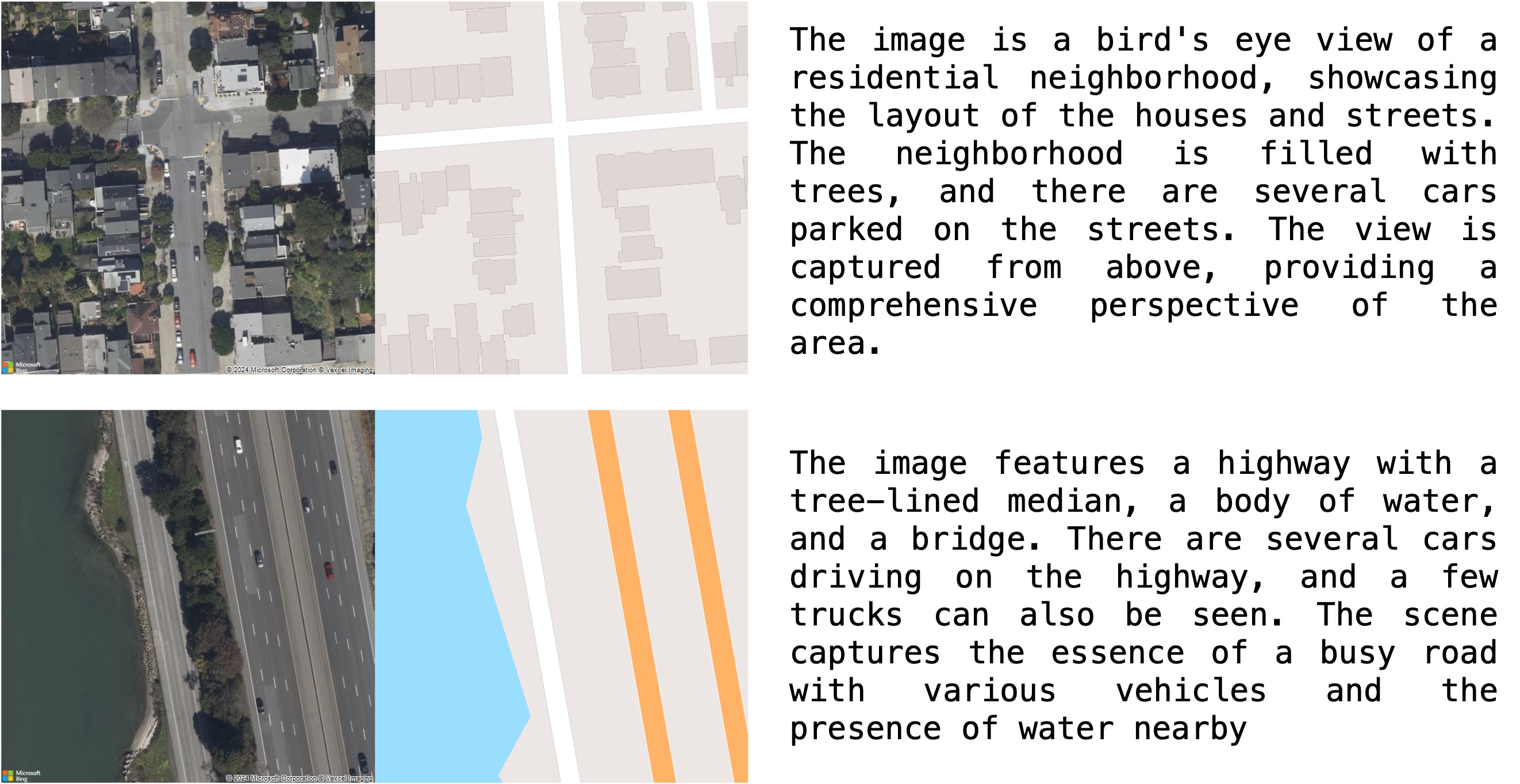
We present GeoSynth, a model for synthesizing satellite images with global style and image-driven layout control. The global style control is via textual prompts or geographic location. These enable the specification of scene semantics or regional appearance respectively, and can be used together. We train our model on a large dataset of paired satellite imagery, with automatically generated captions, and OpenStreetMap data. We evaluate various combinations of control inputs, including different types of layout controls. Results demonstrate that our model can generate diverse, high-quality images and exhibits excellent zero-shot generalization. The code and model checkpoints are available at https://github.com/mvrl/GeoSynth.
Create account to get full access
Overview
- Introduces GeoSynth, a novel approach for generating high-resolution satellite images that are contextually aware
- Leverages diffusion models to produce realistic and diverse synthetic satellite images
- Addresses the challenges of generating high-quality, diverse, and context-aware satellite imagery
Plain English Explanation
GeoSynth is a new technique for creating realistic, high-resolution satellite images. It uses a special type of machine learning model called a "diffusion model" to generate these images. Diffusion models can produce a wide variety of synthetic images that look very natural and lifelike.
The key innovation of GeoSynth is that it can generate satellite images that are "contextually aware." This means the images not only look realistic, but they also reflect the geographical and environmental context of the location being depicted. For example, a synthetic image of a city would include the appropriate buildings, roads, and landscape features you'd expect to see in that particular urban setting.
This is an important advance because it allows researchers and developers to more easily create large, diverse datasets of high-quality satellite imagery. These datasets can then be used to train other AI models for tasks like automated urban map extraction or predicting image geolocations. Having access to realistic, context-aware synthetic data can help overcome the limitations of relying solely on real-world satellite imagery, which can be expensive to acquire and may have biases or gaps.
Technical Explanation
GeoSynth leverages diffusion models, a type of generative AI system, to create high-resolution satellite images that capture the contextual details of different geographic locations. Diffusion models work by starting with random noise and iteratively refining it to match the characteristics of a target dataset, in this case, satellite imagery.
The key components of the GeoSynth architecture include:
- A diffusion model that can generate high-resolution (1024x1024 pixel) satellite images
- A context encoder module that captures the geographic and environmental features of a location, such as terrain, land cover, and building styles
- A fusion mechanism that integrates the generated image with the contextual information to produce the final synthetic satellite image
The researchers trained and evaluated GeoSynth on several satellite image datasets, demonstrating its ability to generate diverse, realistic, and contextually accurate synthetic imagery. They also showed how the synthetic data produced by GeoSynth can be used to improve the performance of other AI models, such as those for geolocating images or text-to-image synthesis with artistic styles.
Critical Analysis
The GeoSynth paper presents a promising approach for generating high-quality, context-aware satellite imagery, but it also acknowledges several limitations and areas for future research:
- The current version of GeoSynth is limited to generating 1024x1024 pixel images, which may not be sufficient for all applications. Exploring ways to scale up the resolution further would be valuable.
- The paper only evaluates GeoSynth on a few satellite image datasets, so its performance on a wider range of geographic regions and data sources is unclear. Evaluating the efficacy of cut-and-paste data augmentation techniques could also help improve the diversity of the synthetic data.
- While GeoSynth can capture contextual features, the paper does not explore in depth how these features are represented and integrated into the final synthetic images. Further research into the interpretability and controllability of the contextual information would be helpful.
Overall, the GeoSynth approach represents an important advance in satellite image synthesis, with the potential to enable more effective AI-powered applications in fields like urban planning, disaster response, and environmental monitoring. However, as with any new technology, continued research and refinement will be necessary to address the remaining challenges and unlock the full potential of this technology.
Conclusion
The GeoSynth paper presents a novel approach for generating high-resolution, contextually-aware satellite imagery using diffusion models. This work addresses a key challenge in the field of satellite image synthesis, which is the ability to produce diverse, realistic, and geographically accurate synthetic data.
By incorporating contextual information about the geographic and environmental features of a location, GeoSynth can generate synthetic satellite images that are not only visually convincing, but also reflect the real-world characteristics of the depicted areas. This advancement has the potential to significantly benefit a wide range of applications that rely on satellite imagery, from urban planning to environmental monitoring to disaster response.
As the research in this area continues to evolve, it will be important to further explore ways to scale up the resolution of the synthetic images, broaden the diversity of the training data, and improve the interpretability and controllability of the contextual features. Nonetheless, the GeoSynth paper represents an important step forward in the quest to unlock the full potential of AI-powered satellite image synthesis.
This summary was produced with help from an AI and may contain inaccuracies - check out the links to read the original source documents!
Related Papers
Bird's-Eye View to Street-View: A Survey
Khawlah Bajbaa, Muhammad Usman, Saeed Anwar, Ibrahim Radwan, Abdul Bais
0
0
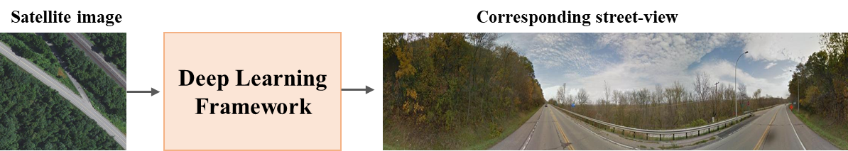
In recent years, street view imagery has grown to become one of the most important sources of geospatial data collection and urban analytics, which facilitates generating meaningful insights and assisting in decision-making. Synthesizing a street-view image from its corresponding satellite image is a challenging task due to the significant differences in appearance and viewpoint between the two domains. In this study, we screened 20 recent research papers to provide a thorough review of the state-of-the-art of how street-view images are synthesized from their corresponding satellite counterparts. The main findings are: (i) novel deep learning techniques are required for synthesizing more realistic and accurate street-view images; (ii) more datasets need to be collected for public usage; and (iii) more specific evaluation metrics need to be investigated for evaluating the generated images appropriately. We conclude that, due to applying outdated deep learning techniques, the recent literature failed to generate detailed and diverse street-view images.
5/16/2024

Using Game Engines and Machine Learning to Create Synthetic Satellite Imagery for a Tabletop Verification Exercise
Johannes Hoster, Sara Al-Sayed, Felix Biessmann, Alexander Glaser, Kristian Hildebrand, Igor Moric, Tuong Vy Nguyen
0
0
Satellite imagery is regarded as a great opportunity for citizen-based monitoring of activities of interest. Relevant imagery may however not be available at sufficiently high resolution, quality, or cadence -- let alone be uniformly accessible to open-source analysts. This limits an assessment of the true long-term potential of citizen-based monitoring of nuclear activities using publicly available satellite imagery. In this article, we demonstrate how modern game engines combined with advanced machine-learning techniques can be used to generate synthetic imagery of sites of interest with the ability to choose relevant parameters upon request; these include time of day, cloud cover, season, or level of activity onsite. At the same time, resolution and off-nadir angle can be adjusted to simulate different characteristics of the satellite. While there are several possible use-cases for synthetic imagery, here we focus on its usefulness to support tabletop exercises in which simple monitoring scenarios can be examined to better understand verification capabilities enabled by new satellite constellations and very short revisit times.
6/26/2024
📈
MetaEarth: A Generative Foundation Model for Global-Scale Remote Sensing Image Generation
Zhiping Yu, Chenyang Liu, Liqin Liu, Zhenwei Shi, Zhengxia Zou
0
0
The recent advancement of generative foundational models has ushered in a new era of image generation in the realm of natural images, revolutionizing art design, entertainment, environment simulation, and beyond. Despite producing high-quality samples, existing methods are constrained to generating images of scenes at a limited scale. In this paper, we present MetaEarth, a generative foundation model that breaks the barrier by scaling image generation to a global level, exploring the creation of worldwide, multi-resolution, unbounded, and virtually limitless remote sensing images. In MetaEarth, we propose a resolution-guided self-cascading generative framework, which enables the generating of images at any region with a wide range of geographical resolutions. To achieve unbounded and arbitrary-sized image generation, we design a novel noise sampling strategy for denoising diffusion models by analyzing the generation conditions and initial noise. To train MetaEarth, we construct a large dataset comprising multi-resolution optical remote sensing images with geographical information. Experiments have demonstrated the powerful capabilities of our method in generating global-scale images. Additionally, the MetaEarth serves as a data engine that can provide high-quality and rich training data for downstream tasks. Our model opens up new possibilities for constructing generative world models by simulating Earth visuals from an innovative overhead perspective.
5/29/2024

Generating Synthetic Satellite Imagery With Deep-Learning Text-to-Image Models -- Technical Challenges and Implications for Monitoring and Verification
Tuong Vy Nguyen, Alexander Glaser, Felix Biessmann
0
0
Novel deep-learning (DL) architectures have reached a level where they can generate digital media, including photorealistic images, that are difficult to distinguish from real data. These technologies have already been used to generate training data for Machine Learning (ML) models, and large text-to-image models like DALL-E 2, Imagen, and Stable Diffusion are achieving remarkable results in realistic high-resolution image generation. Given these developments, issues of data authentication in monitoring and verification deserve a careful and systematic analysis: How realistic are synthetic images? How easily can they be generated? How useful are they for ML researchers, and what is their potential for Open Science? In this work, we use novel DL models to explore how synthetic satellite images can be created using conditioning mechanisms. We investigate the challenges of synthetic satellite image generation and evaluate the results based on authenticity and state-of-the-art metrics. Furthermore, we investigate how synthetic data can alleviate the lack of data in the context of ML methods for remote-sensing. Finally we discuss implications of synthetic satellite imagery in the context of monitoring and verification.
4/12/2024