No More Potentially Dynamic Objects: Static Point Cloud Map Generation based on 3D Object Detection and Ground Projection

0

Sign in to get full access
Overview
- This paper proposes a novel method for generating static point cloud maps using 3D object detection and ground projection.
- The approach aims to remove potentially dynamic objects from the point cloud, resulting in a more reliable and consistent map for various applications.
- The method leverages deep learning-based 3D object detection to identify and remove moving objects, followed by ground projection to create a stable and accurate point cloud representation.
Plain English Explanation
The paper introduces a new way to create 3D maps using laser scanning technology (known as LiDAR). Traditional LiDAR maps can include moving objects like cars or people, which can make the maps less reliable over time. The researchers developed a method to detect and remove these dynamic objects, leaving only the static elements like buildings and roads.
The process works by first using a deep learning model to identify and classify the 3D objects in the LiDAR point cloud data. This allows the system to distinguish between static and moving objects. Then, the researchers project the remaining static points onto the ground plane, creating a clean, unchanging map that captures the essential features of the environment.
This approach has several advantages over traditional LiDAR mapping. By removing dynamic objects, the resulting map is more consistent and reliable over time, as it won't be affected by the constant movement of cars, pedestrians, and other elements. This makes the maps more useful for applications like autonomous vehicles, traffic management, and urban planning.
Technical Explanation
The paper presents a novel approach for generating static point cloud maps by leveraging 3D object detection and ground projection. The key steps of the method are as follows:
-
3D Object Detection: The researchers employ a deep learning-based 3D object detector to identify and classify objects within the LiDAR point cloud data. This allows the system to distinguish between static and dynamic objects, such as buildings, roads, and moving vehicles.
-
Ground Projection: After removing the dynamic objects, the remaining static points are projected onto the ground plane. This step results in a 2D representation of the static elements in the environment, creating a more stable and consistent point cloud map.
The authors evaluate their approach on several public datasets and demonstrate its effectiveness in generating high-quality static point cloud maps. Compared to traditional LiDAR mapping techniques, the proposed method shows improved performance in terms of map consistency and reliability over time.
Critical Analysis
The paper presents a thoughtful approach to improving the reliability and usefulness of LiDAR-based maps by addressing the challenge of dynamic objects. The authors' use of 3D object detection to remove moving elements is a well-designed solution, and the ground projection step helps to create a more stable and consistent representation of the environment.
One potential limitation of the method, as mentioned in the paper, is the reliance on the accuracy of the 3D object detection model. If the object classification is not sufficiently reliable, the static map generation could be affected. Additionally, the authors note that the ground projection step may introduce some distortion or loss of information, particularly for objects that are not flush with the ground.
Further research could explore ways to address these potential issues, such as investigating more robust object detection algorithms or exploring alternative mapping techniques that better preserve the 3D structure of the environment. It would also be interesting to see how this approach compares to other methods for generating static point cloud maps, such as those described in the Point Cloud Obstacle Detection and Map Filtration and Empowering Urban Traffic Management with Elevated 3D LiDAR papers.
Conclusion
The proposed method for static point cloud map generation based on 3D object detection and ground projection represents a promising approach to improving the reliability and usefulness of LiDAR-based maps. By removing potentially dynamic objects, the resulting maps are more stable and consistent over time, making them valuable for a wide range of applications, from autonomous vehicles to urban planning. While the method has some potential limitations, the authors have demonstrated the effectiveness of their approach and opened up new avenues for further research in this important area of 3D mapping and perception.
This summary was produced with help from an AI and may contain inaccuracies - check out the links to read the original source documents!
Related Papers
0
No More Potentially Dynamic Objects: Static Point Cloud Map Generation based on 3D Object Detection and Ground Projection
Soojin Woo, Donghwi Jung, Seong-Woo Kim
In this paper, we propose an algorithm to generate a static point cloud map based on LiDAR point cloud data. Our proposed pipeline detects dynamic objects using 3D object detectors and projects points of dynamic objects onto the ground. Typically, point cloud data acquired in real-time serves as a snapshot of the surrounding areas containing both static objects and dynamic objects. The static objects include buildings and trees, otherwise, the dynamic objects contain objects such as parked cars that change their position over time. Removing dynamic objects from the point cloud map is crucial as they can degrade the quality and localization accuracy of the map. To address this issue, in this paper, we propose an algorithm that creates a map only consisting of static objects. We apply a 3D object detection algorithm to the point cloud data which are obtained from LiDAR to implement our pipeline. We then stack the points to create the map after performing ground segmentation and projection. As a result, not only we can eliminate currently dynamic objects at the time of map generation but also potentially dynamic objects such as parked vehicles. We validate the performance of our method using two kinds of datasets collected on real roads: KITTI and our dataset. The result demonstrates the capability of our proposal to create an accurate static map excluding dynamic objects from input point clouds. Also, we verified the improved performance of localization using a generated map based on our method.
Read more7/2/2024

0
TOSS: Real-time Tracking and Moving Object Segmentation for Static Scene Mapping
Seoyeon Jang, Minho Oh, Byeongho Yu, I Made Aswin Nahrendra, Seungjae Lee, Hyungtae Lim, Hyun Myung
Safe navigation with simultaneous localization and mapping (SLAM) for autonomous robots is crucial in challenging environments. To achieve this goal, detecting moving objects in the surroundings and building a static map are essential. However, existing moving object segmentation methods have been developed separately for each field, making it challenging to perform real-time navigation and precise static map building simultaneously. In this paper, we propose an integrated real-time framework that combines online tracking-based moving object segmentation with static map building. For safe navigation, we introduce a computationally efficient hierarchical association cost matrix to enable real-time moving object segmentation. In the context of precise static mapping, we present a voting-based method, DS-Voting, designed to achieve accurate dynamic object removal and static object recovery by emphasizing their spatio-temporal differences. We evaluate our proposed method quantitatively and qualitatively in the SemanticKITTI dataset and real-world challenging environments. The results demonstrate that dynamic objects can be clearly distinguished and incorporated into static map construction, even in stairs, steep hills, and dense vegetation.
Read more8/13/2024
0
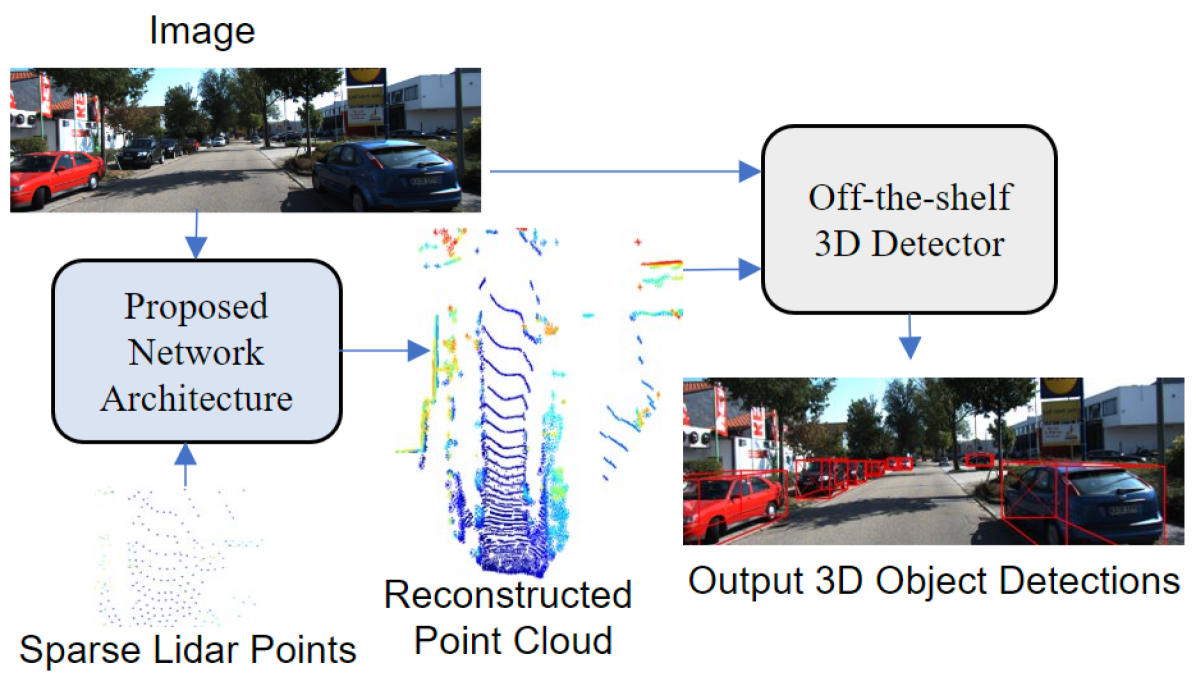
Sparse Points to Dense Clouds: Enhancing 3D Detection with Limited LiDAR Data
Aakash Kumar, Chen Chen, Ajmal Mian, Neils Lobo, Mubarak Shah
3D detection is a critical task that enables machines to identify and locate objects in three-dimensional space. It has a broad range of applications in several fields, including autonomous driving, robotics and augmented reality. Monocular 3D detection is attractive as it requires only a single camera, however, it lacks the accuracy and robustness required for real world applications. High resolution LiDAR on the other hand, can be expensive and lead to interference problems in heavy traffic given their active transmissions. We propose a balanced approach that combines the advantages of monocular and point cloud-based 3D detection. Our method requires only a small number of 3D points, that can be obtained from a low-cost, low-resolution sensor. Specifically, we use only 512 points, which is just 1% of a full LiDAR frame in the KITTI dataset. Our method reconstructs a complete 3D point cloud from this limited 3D information combined with a single image. The reconstructed 3D point cloud and corresponding image can be used by any multi-modal off-the-shelf detector for 3D object detection. By using the proposed network architecture with an off-the-shelf multi-modal 3D detector, the accuracy of 3D detection improves by 20% compared to the state-of-the-art monocular detection methods and 6% to 9% compare to the baseline multi-modal methods on KITTI and JackRabbot datasets.
Read more4/11/2024

0
LiDAR-based Real-Time Object Detection and Tracking in Dynamic Environments
Wenqiang Du, Giovanni Beltrame
In dynamic environments, the ability to detect and track moving objects in real-time is crucial for autonomous robots to navigate safely and effectively. Traditional methods for dynamic object detection rely on high accuracy odometry and maps to detect and track moving objects. However, these methods are not suitable for long-term operation in dynamic environments where the surrounding environment is constantly changing. In order to solve this problem, we propose a novel system for detecting and tracking dynamic objects in real-time using only LiDAR data. By emphasizing the extraction of low-frequency components from LiDAR data as feature points for foreground objects, our method significantly reduces the time required for object clustering and movement analysis. Additionally, we have developed a tracking approach that employs intensity-based ego-motion estimation along with a sliding window technique to assess object movements. This enables the precise identification of moving objects and enhances the system's resilience to odometry drift. Our experiments show that this system can detect and track dynamic objects in real-time with an average detection accuracy of 88.7% and a recall rate of 89.1%. Furthermore, our system demonstrates resilience against the prolonged drift typically associated with front-end only LiDAR odometry. All of the source code, labeled dataset, and the annotation tool are available at: https://github.com/MISTLab/lidar_dynamic_objects_detection.git
Read more7/8/2024