Planetary Causal Inference: Implications for the Geography of Poverty
2406.02584
0
0
Abstract
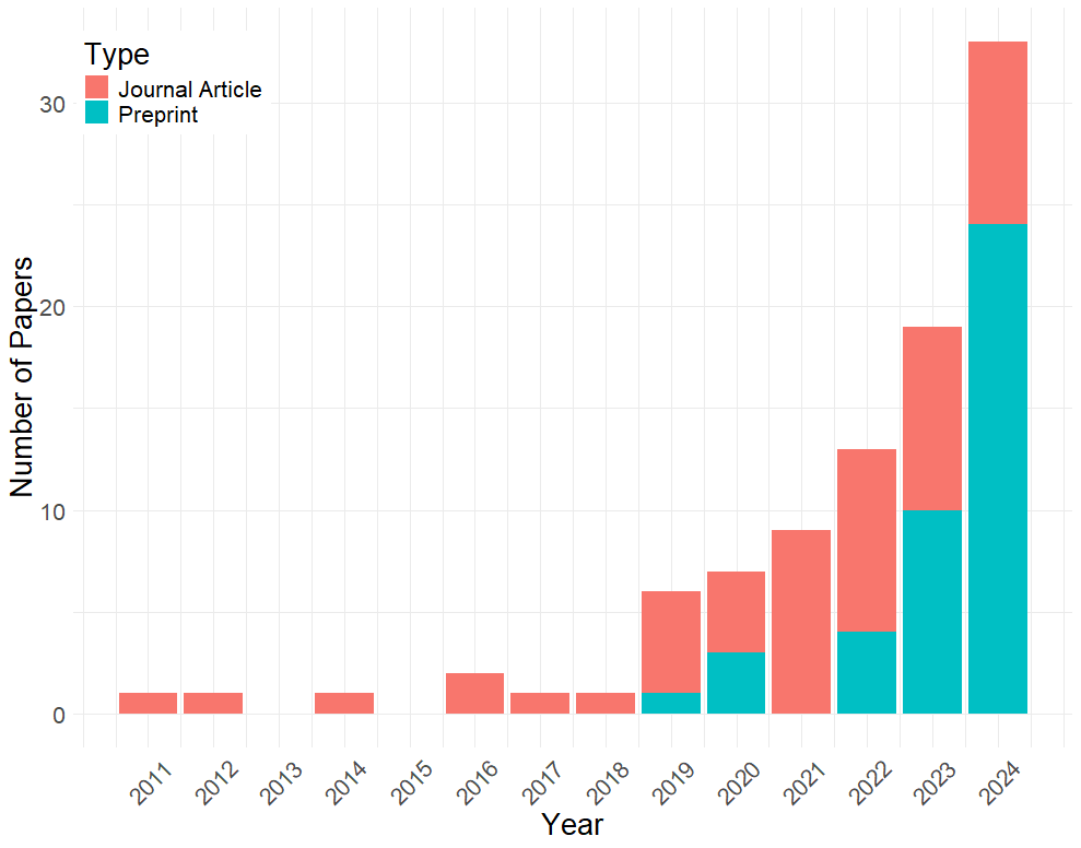
Earth observation data such as satellite imagery can, when combined with machine learning, have profound impacts on our understanding of the geography of poverty through the prediction of living conditions, especially where government-derived economic indicators are either unavailable or potentially untrustworthy. Recent work has progressed in using EO data not only to predict spatial economic outcomes, but also to explore cause and effect, an understanding which is critical for downstream policy analysis. In this review, we first document the growth of interest in EO-ML analyses in the causal space. We then trace the relationship between spatial statistics and EO-ML methods before discussing the four ways in which EO data has been used in causal ML pipelines -- (1.) poverty outcome imputation for downstream causal analysis, (2.) EO image deconfounding, (3.) EO-based treatment effect heterogeneity, and (4.) EO-based transportability analysis. We conclude by providing a workflow for how researchers can incorporate EO data in causal ML analysis going forward.
Create account to get full access
Overview
- This paper explores the potential of using Earth observation (EO) data and causal inference methods to better understand the geography of poverty.
- The authors explore how EO data, combined with causal inference techniques, can provide insights into the factors driving poverty at a global scale.
- The paper discusses the implications of this approach for policymakers and development practitioners working to address poverty and inequality.
Plain English Explanation
The research paper looks at how we can use data from satellites and other Earth observation sources, along with advanced statistical techniques, to better understand the causes of poverty around the world.
Rather than just looking at poverty levels in different regions, the authors argue we can use these tools to figure out what specific factors are driving poverty in certain areas. This could include things like access to infrastructure, natural resources, or economic opportunities.
By gaining a deeper, more nuanced understanding of the causes of poverty, policymakers and development organizations can hopefully design more effective programs and interventions to reduce poverty and inequality. The paper suggests this "causal inference" approach, which tries to identify the root causes of problems, could be a powerful complement to existing poverty mapping and monitoring efforts.
Technical Explanation
The paper presents a framework for "planetary causal inference" - using Earth observation data and causal modeling techniques to understand the drivers of poverty at a global scale. The authors argue this can provide deeper insights than traditional poverty mapping approaches.
The key elements of the technical approach include:
- Leveraging a wide range of Earth observation data sources, from satellite imagery to gridded socioeconomic indicators [Impact Assessment of Missing Data on Model Predictions for Earth Observation, Responsible AI for Earth Observation].
- Applying causal inference methods, such as structural equation modeling and causal graph analysis, to uncover the underlying drivers of poverty [EarthNets: Empowering AI for Earth Observation].
- Accounting for spatial dependence and geographic heterogeneity in the drivers of poverty [Impacts of Color and Texture Distortions in Earth Observation Data].
- Developing "geography-agnostic" models that can work across diverse settings [Classification for Everyone: Building Geography-Agnostic Models for Fairer AI].
The authors demonstrate the potential of this approach through a series of case studies across different world regions, highlighting how it can uncover novel insights about the complex interplay of factors contributing to poverty.
Critical Analysis
The paper makes a compelling case for the value of using Earth observation data and causal inference techniques to better understand the drivers of global poverty. However, the authors acknowledge several important caveats and limitations:
- The availability and quality of Earth observation data can vary significantly across different regions, which may introduce biases or gaps in the analysis.
- Causal inference methods rely on certain assumptions that may not always hold in real-world settings, particularly when dealing with complex socioeconomic systems.
- The interpretability and generalizability of the models developed in this research remain open questions that require further investigation.
Additionally, while the paper discusses the potential policy implications of this work, it does not delve deeply into the practical challenges of implementing such an approach in the context of poverty alleviation programs and policymaking.
Overall, this research represents an important step forward in leveraging the power of Earth observation and causal inference to tackle global development challenges. However, continued refinement, validation, and collaboration with domain experts will be crucial to realize the full potential of this approach.
Conclusion
This paper presents a novel framework for "planetary causal inference" that uses Earth observation data and advanced statistical techniques to better understand the drivers of global poverty. By moving beyond traditional poverty mapping approaches and uncovering the underlying causal mechanisms, the authors argue this work can inform more effective policymaking and development interventions.
While the technical approach has several important caveats and limitations, the paper demonstrates the significant potential of this line of research. As Earth observation capabilities and causal inference methods continue to evolve, this work could play a crucial role in helping policymakers and practitioners tackle the complex challenge of reducing poverty and inequality worldwide.
This summary was produced with help from an AI and may contain inaccuracies - check out the links to read the original source documents!
Related Papers

Impact Assessment of Missing Data in Model Predictions for Earth Observation Applications
Francisco Mena, Diego Arenas, Marcela Charfuelan, Marlon Nuske, Andreas Dengel
0
0
Earth observation (EO) applications involving complex and heterogeneous data sources are commonly approached with machine learning models. However, there is a common assumption that data sources will be persistently available. Different situations could affect the availability of EO sources, like noise, clouds, or satellite mission failures. In this work, we assess the impact of missing temporal and static EO sources in trained models across four datasets with classification and regression tasks. We compare the predictive quality of different methods and find that some are naturally more robust to missing data. The Ensemble strategy, in particular, achieves a prediction robustness up to 100%. We evidence that missing scenarios are significantly more challenging in regression than classification tasks. Finally, we find that the optical view is the most critical view when it is missing individually.
5/14/2024

Responsible AI for Earth Observation
Pedram Ghamisi, Weikang Yu, Andrea Marinoni, Caroline M. Gevaert, Claudio Persello, Sivasakthy Selvakumaran, Manuela Girotto, Benjamin P. Horton, Philippe Rufin, Patrick Hostert, Fabio Pacifici, Peter M. Atkinson
0
0
The convergence of artificial intelligence (AI) and Earth observation (EO) technologies has brought geoscience and remote sensing into an era of unparalleled capabilities. AI's transformative impact on data analysis, particularly derived from EO platforms, holds great promise in addressing global challenges such as environmental monitoring, disaster response and climate change analysis. However, the rapid integration of AI necessitates a careful examination of the responsible dimensions inherent in its application within these domains. In this paper, we represent a pioneering effort to systematically define the intersection of AI and EO, with a central focus on responsible AI practices. Specifically, we identify several critical components guiding this exploration from both academia and industry perspectives within the EO field: AI and EO for social good, mitigating unfair biases, AI security in EO, geo-privacy and privacy-preserving measures, as well as maintaining scientific excellence, open data, and guiding AI usage based on ethical principles. Furthermore, the paper explores potential opportunities and emerging trends, providing valuable insights for future research endeavors.
6/3/2024
GeoSEE: Regional Socio-Economic Estimation With a Large Language Model
Sungwon Han, Donghyun Ahn, Seungeon Lee, Minhyuk Song, Sungwon Park, Sangyoon Park, Jihee Kim, Meeyoung Cha
0
0
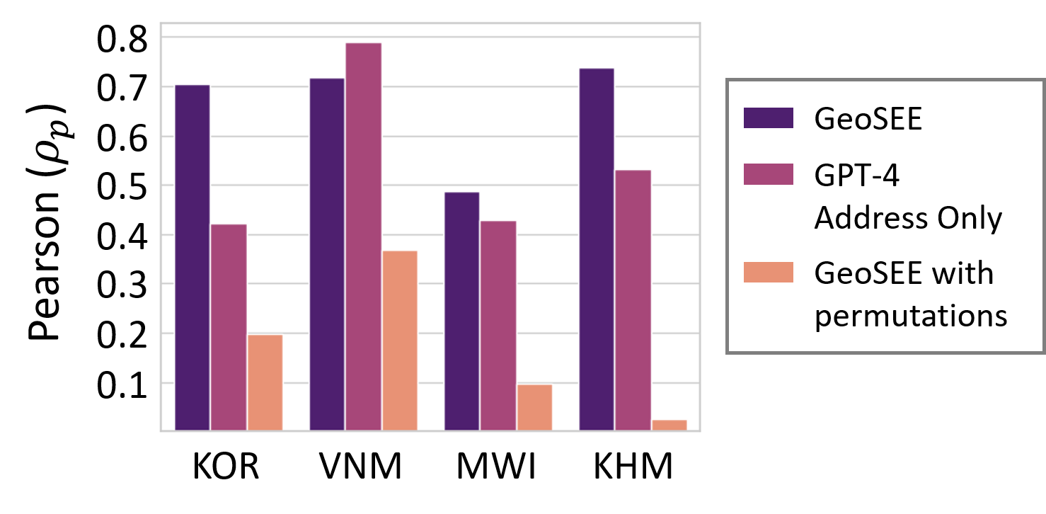
Moving beyond traditional surveys, combining heterogeneous data sources with AI-driven inference models brings new opportunities to measure socio-economic conditions, such as poverty and population, over expansive geographic areas. The current research presents GeoSEE, a method that can estimate various socio-economic indicators using a unified pipeline powered by a large language model (LLM). Presented with a diverse set of information modules, including those pre-constructed from satellite imagery, GeoSEE selects which modules to use in estimation, for each indicator and country. This selection is guided by the LLM's prior socio-geographic knowledge, which functions similarly to the insights of a domain expert. The system then computes target indicators via in-context learning after aggregating results from selected modules in the format of natural language-based texts. Comprehensive evaluation across countries at various stages of development reveals that our method outperforms other predictive models in both unsupervised and low-shot contexts. This reliable performance under data-scarce setting in under-developed or developing countries, combined with its cost-effectiveness, underscores its potential to continuously support and monitor the progress of Sustainable Development Goals, such as poverty alleviation and equitable growth, on a global scale.
6/17/2024

Data Augmentation in Earth Observation: A Diffusion Model Approach
Tiago Sousa, Beno^it Ries, Nicolas Guelfi
0
0
The scarcity of high-quality Earth Observation (EO) imagery poses a significant challenge, despite its critical role in enabling precise analysis and informed decision-making across various sectors. This scarcity is primarily due to atmospheric conditions, seasonal variations, and limited geographical coverage, which complicates the application of Artificial Intelligence (AI) in EO. Data augmentation, a widely used technique in AI that involves generating additional data mainly through parameterized image transformations, has been employed to increase the volume and diversity of data. However, this method often falls short in generating sufficient diversity across key semantic axes, adversely affecting the accuracy of EO applications. To address this issue, we propose a novel four-stage approach aimed at improving the diversity of augmented data by integrating diffusion models. Our approach employs meta-prompts for instruction generation, harnesses general-purpose vision-language models for generating rich captions, fine-tunes an Earth Observation diffusion model, and iteratively augments data. We conducted extensive experiments using four different data augmentation techniques, and our approach consistently demonstrated improvements, outperforming the established augmentation methods, revealing its effectiveness in generating semantically rich and diverse EO images.
6/11/2024