RAPiD-Seg: Range-Aware Pointwise Distance Distribution Networks for 3D LiDAR Segmentation

0

Sign in to get full access
Overview
- This paper introduces RAPiD-Seg, a deep learning architecture for 3D LiDAR point cloud segmentation that leverages range-aware pointwise distance distribution features.
- The approach aims to improve segmentation accuracy by capturing the spatial and range information of 3D points more effectively than previous methods.
- RAPiD-Seg is evaluated on several benchmark datasets for 3D semantic segmentation, demonstrating state-of-the-art performance.
Plain English Explanation
LiDAR systems create 3D point clouds by measuring the distance between the sensor and objects in the environment. These point clouds can be used for tasks like semantic segmentation, where the goal is to assign a category label (e.g., road, building, vehicle) to each 3D point.
The authors of this paper propose a new deep learning model called RAPiD-Seg that is designed to improve the accuracy of 3D point cloud segmentation. The key idea is to better capture the spatial relationships and distance information of the points, which can provide valuable cues for accurate classification.
Specifically, RAPiD-Seg learns to extract "range-aware pointwise distance distribution" features from the input point cloud. These features encode how the distances between each point and its neighbors vary across different ranges from the sensor. By incorporating this range-aware information, the model can more effectively distinguish between objects at different depths, leading to improved segmentation performance.
RAPiD-Seg is evaluated on several benchmark datasets for 3D semantic segmentation, where it demonstrates state-of-the-art results compared to other leading methods. This suggests that the range-aware features learned by the model are indeed valuable for this task and could have broader applications in 3D perception and understanding.
Technical Explanation
The core of the RAPiD-Seg architecture is a neural network module that learns to extract range-aware pointwise distance distribution features from the input 3D point cloud. This module takes as input the 3D coordinates of each point and computes a histogram-like representation that captures the distribution of distances to neighboring points at different ranges from the sensor.
Specifically, the module first divides the space around each point into multiple range bins. It then computes the distances from the point to its neighbors within each range bin and aggregates this information into a compact feature vector. This range-aware pointwise distance distribution feature is then fed into the rest of the RAPiD-Seg network, which uses it in conjunction with other point features to predict the semantic label for each 3D point.
The authors show that this range-aware distance feature provides complementary information to other commonly used point features, such as normalized coordinates and intensity. By fusing these features, RAPiD-Seg is able to outperform previous state-of-the-art methods on several 3D semantic segmentation benchmarks, including ScanNet, S3DIS, and Semantic-KITTI.
Critical Analysis
The authors provide a thorough evaluation of RAPiD-Seg on multiple benchmark datasets, demonstrating its strong performance relative to previous methods. However, the paper does not address some potential limitations or areas for further research.
For example, the range-aware distance features used by RAPiD-Seg rely on accurate point cloud registration and the ability to define meaningful range bins around each point. In real-world scenarios with noisy or sparse LiDAR data, these assumptions may not always hold, which could degrade the model's performance. The authors could have discussed strategies for making RAPiD-Seg more robust to such challenges.
Additionally, the paper does not explore the potential for the range-aware distance features to benefit other 3D perception tasks beyond semantic segmentation, such as object detection or scene understanding. Investigating these applications could further highlight the broader utility of the proposed approach.
Conclusion
The RAPiD-Seg model presented in this paper demonstrates the value of incorporating range-aware pointwise distance distribution features for improving 3D LiDAR point cloud segmentation. By learning to capture the spatial and depth information of the points more effectively than previous methods, RAPiD-Seg achieves state-of-the-art performance on several benchmark datasets.
This work highlights the importance of designing deep learning architectures that can leverage the rich 3D structure and depth cues available in LiDAR data. The range-aware features introduced in this paper could have applications beyond semantic segmentation, potentially benefiting other 3D perception tasks as well. Further research is needed to explore the robustness and generalization of this approach in real-world scenarios.
This summary was produced with help from an AI and may contain inaccuracies - check out the links to read the original source documents!
Related Papers
0
RAPiD-Seg: Range-Aware Pointwise Distance Distribution Networks for 3D LiDAR Segmentation
Li Li, Hubert P. H. Shum, Toby P. Breckon
3D point clouds play a pivotal role in outdoor scene perception, especially in the context of autonomous driving. Recent advancements in 3D LiDAR segmentation often focus intensely on the spatial positioning and distribution of points for accurate segmentation. However, these methods, while robust in variable conditions, encounter challenges due to sole reliance on coordinates and point intensity, leading to poor isometric invariance and suboptimal segmentation. To tackle this challenge, our work introduces Range-Aware Pointwise Distance Distribution (RAPiD) features and the associated RAPiD-Seg architecture. Our RAPiD features exhibit rigid transformation invariance and effectively adapt to variations in point density, with a design focus on capturing the localized geometry of neighboring structures. They utilize inherent LiDAR isotropic radiation and semantic categorization for enhanced local representation and computational efficiency, while incorporating a 4D distance metric that integrates geometric and surface material reflectivity for improved semantic segmentation. To effectively embed high-dimensional RAPiD features, we propose a double-nested autoencoder structure with a novel class-aware embedding objective to encode high-dimensional features into manageable voxel-wise embeddings. Additionally, we propose RAPiD-Seg which incorporates a channel-wise attention fusion and two effective RAPiD-Seg variants, further optimizing the embedding for enhanced performance and generalization. Our method outperforms contemporary LiDAR segmentation work in terms of mIoU on SemanticKITTI (76.1) and nuScenes (83.6) datasets.
Read more9/17/2024
0
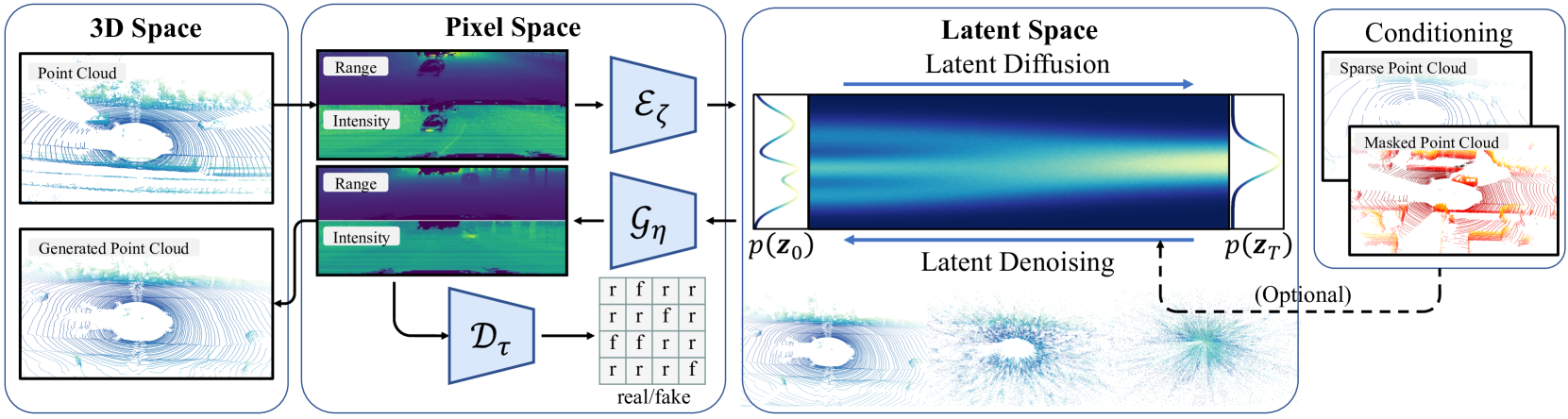
RangeLDM: Fast Realistic LiDAR Point Cloud Generation
Qianjiang Hu, Zhimin Zhang, Wei Hu
Autonomous driving demands high-quality LiDAR data, yet the cost of physical LiDAR sensors presents a significant scaling-up challenge. While recent efforts have explored deep generative models to address this issue, they often consume substantial computational resources with slow generation speeds while suffering from a lack of realism. To address these limitations, we introduce RangeLDM, a novel approach for rapidly generating high-quality range-view LiDAR point clouds via latent diffusion models. We achieve this by correcting range-view data distribution for accurate projection from point clouds to range images via Hough voting, which has a critical impact on generative learning. We then compress the range images into a latent space with a variational autoencoder, and leverage a diffusion model to enhance expressivity. Additionally, we instruct the model to preserve 3D structural fidelity by devising a range-guided discriminator. Experimental results on KITTI-360 and nuScenes datasets demonstrate both the robust expressiveness and fast speed of our LiDAR point cloud generation.
Read more9/11/2024

0
Uplifting Range-View-based 3D Semantic Segmentation in Real-Time with Multi-Sensor Fusion
Shiqi Tan, Hamidreza Fazlali, Yixuan Xu, Yuan Ren, Bingbing Liu
Range-View(RV)-based 3D point cloud segmentation is widely adopted due to its compact data form. However, RV-based methods fall short in providing robust segmentation for the occluded points and suffer from distortion of projected RGB images due to the sparse nature of 3D point clouds. To alleviate these problems, we propose a new LiDAR and Camera Range-view-based 3D point cloud semantic segmentation method (LaCRange). Specifically, a distortion-compensating knowledge distillation (DCKD) strategy is designed to remedy the adverse effect of RV projection of RGB images. Moreover, a context-based feature fusion module is introduced for robust and preservative sensor fusion. Finally, in order to address the limited resolution of RV and its insufficiency of 3D topology, a new point refinement scheme is devised for proper aggregation of features in 2D and augmentation of point features in 3D. We evaluated the proposed method on large-scale autonomous driving datasets ie SemanticKITTI and nuScenes. In addition to being real-time, the proposed method achieves state-of-the-art results on nuScenes benchmark
Read more7/16/2024
0
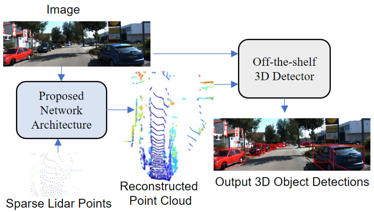
Sparse Points to Dense Clouds: Enhancing 3D Detection with Limited LiDAR Data
Aakash Kumar, Chen Chen, Ajmal Mian, Neils Lobo, Mubarak Shah
3D detection is a critical task that enables machines to identify and locate objects in three-dimensional space. It has a broad range of applications in several fields, including autonomous driving, robotics and augmented reality. Monocular 3D detection is attractive as it requires only a single camera, however, it lacks the accuracy and robustness required for real world applications. High resolution LiDAR on the other hand, can be expensive and lead to interference problems in heavy traffic given their active transmissions. We propose a balanced approach that combines the advantages of monocular and point cloud-based 3D detection. Our method requires only a small number of 3D points, that can be obtained from a low-cost, low-resolution sensor. Specifically, we use only 512 points, which is just 1% of a full LiDAR frame in the KITTI dataset. Our method reconstructs a complete 3D point cloud from this limited 3D information combined with a single image. The reconstructed 3D point cloud and corresponding image can be used by any multi-modal off-the-shelf detector for 3D object detection. By using the proposed network architecture with an off-the-shelf multi-modal 3D detector, the accuracy of 3D detection improves by 20% compared to the state-of-the-art monocular detection methods and 6% to 9% compare to the baseline multi-modal methods on KITTI and JackRabbot datasets.
Read more4/11/2024