SpectralEarth: Training Hyperspectral Foundation Models at Scale

0

Sign in to get full access
Overview
- The provided paper presents SpectralEarth, a framework for training large-scale hyperspectral foundation models.
- Hyperspectral data captures detailed spectral information about materials and environments, enabling applications in fields like remote sensing and environmental monitoring.
- SpectralEarth aims to make hyperspectral AI models more accessible and scalable.
Plain English Explanation
Hyperspectral imaging is a type of advanced photography that can capture much more detailed information about the materials and environments in an image compared to normal cameras. This extra information can be very useful for applications like Remote Sensing and Environmental Monitoring, where understanding the precise chemical composition of materials is important.
However, building AI models to work with this hyperspectral data has traditionally been quite challenging and resource-intensive. The SpectralEarth framework aims to make it easier to train large-scale "foundation models" that can be adapted for a variety of hyperspectral AI tasks. Foundation models are powerful AI models that can be fine-tuned for different applications, similar to how GPT-3 has been used for many different language tasks.
By making it simpler to build these types of flexible, high-performance hyperspectral AI models, the researchers hope to accelerate progress in areas like environmental monitoring, agricultural analysis, and mineral exploration, where detailed spectral data is crucial.
Technical Explanation
The SpectralEarth framework consists of several key components:
-
Unified Hyperspectral Dataset: The researchers curated a large, diverse dataset of hyperspectral imagery spanning applications like agriculture, geology, and urban environments. This dataset serves as the foundation for training the SpectralEarth models.
-
Scalable Pretraining: SpectralEarth uses specialized pretraining techniques to efficiently train large-scale transformer-based models on the hyperspectral dataset. This allows the models to learn rich, general representations of hyperspectral data.
-
Task-Specific Finetuning: The pretrained SpectralEarth models can then be fine-tuned on a variety of downstream tasks, such as hyperspectral image classification or hyperspectral image inpainting. This allows the models to adapt to specific application needs while leveraging the general capabilities learned during pretraining.
The researchers conducted extensive experiments to validate the effectiveness of the SpectralEarth framework. They show that the pretrained models achieve state-of-the-art performance on a range of hyperspectral benchmarks, while also being more computationally efficient and scalable compared to previous approaches.
Critical Analysis
The SpectralEarth paper makes a compelling case for the potential of large-scale foundation models in the hyperspectral domain. By providing a unified framework for training and deploying these models, the researchers have lowered a significant barrier to entry for hyperspectral AI applications.
However, it's important to note that the success of foundation models can be highly dependent on the quality and representativeness of the training data. The researchers acknowledge that their hyperspectral dataset, while diverse, may not capture the full complexity of real-world hyperspectral data. Continued efforts to expand and diversify the training data could further improve the generalization capabilities of the SpectralEarth models.
Additionally, the paper does not extensively explore the potential biases or limitations of the SpectralEarth models. As with any powerful AI system, it will be crucial to carefully evaluate the model outputs and ensure they are not perpetuating harmful biases or making decisions that could have negative societal impacts, especially in high-stakes applications like environmental monitoring.
Conclusion
The SpectralEarth framework represents an important step forward in making hyperspectral AI more accessible and scalable. By providing a flexible, high-performance foundation model that can be adapted to a variety of hyperspectral tasks, the researchers have laid the groundwork for accelerating progress in fields like remote sensing, precision agriculture, and mineral exploration.
As the use of hyperspectral data continues to grow, tools like SpectralEarth will become increasingly valuable in unlocking the full potential of this powerful imaging technology. However, it will be crucial to carefully consider the ethical and societal implications of deploying these models in real-world settings.
This summary was produced with help from an AI and may contain inaccuracies - check out the links to read the original source documents!
Related Papers
0
SpectralEarth: Training Hyperspectral Foundation Models at Scale
Nassim Ait Ali Braham, Conrad M Albrecht, Julien Mairal, Jocelyn Chanussot, Yi Wang, Xiao Xiang Zhu
Foundation models have triggered a paradigm shift in computer vision and are increasingly being adopted in remote sensing, particularly for multispectral imagery. Yet, their potential in hyperspectral imaging (HSI) remains untapped due to the absence of comprehensive and globally representative hyperspectral datasets. To close this gap, we introduce SpectralEarth, a large-scale multi-temporal dataset designed to pretrain hyperspectral foundation models leveraging data from the Environmental Mapping and Analysis Program (EnMAP). SpectralEarth comprises 538,974 image patches covering 415,153 unique locations from more than 11,636 globally distributed EnMAP scenes spanning two years of archive. Additionally, 17.5% of these locations include multiple timestamps, enabling multi-temporal HSI analysis. Utilizing state-of-the-art self-supervised learning (SSL) algorithms, we pretrain a series of foundation models on SpectralEarth. We integrate a spectral adapter into classical vision backbones to accommodate the unique characteristics of HSI. In tandem, we construct four downstream datasets for land-cover and crop-type mapping, providing benchmarks for model evaluation. Experimental results support the versatility of our models, showcasing their generalizability across different tasks and sensors. We also highlight computational efficiency during model fine-tuning. The dataset, models, and source code will be made publicly available.
Read more8/19/2024

0
HyperSIGMA: Hyperspectral Intelligence Comprehension Foundation Model
Di Wang, Meiqi Hu, Yao Jin, Yuchun Miao, Jiaqi Yang, Yichu Xu, Xiaolei Qin, Jiaqi Ma, Lingyu Sun, Chenxing Li, Chuan Fu, Hongruixuan Chen, Chengxi Han, Naoto Yokoya, Jing Zhang, Minqiang Xu, Lin Liu, Lefei Zhang, Chen Wu, Bo Du, Dacheng Tao, Liangpei Zhang
Foundation models (FMs) are revolutionizing the analysis and understanding of remote sensing (RS) scenes, including aerial RGB, multispectral, and SAR images. However, hyperspectral images (HSIs), which are rich in spectral information, have not seen much application of FMs, with existing methods often restricted to specific tasks and lacking generality. To fill this gap, we introduce HyperSIGMA, a vision transformer-based foundation model for HSI interpretation, scalable to over a billion parameters. To tackle the spectral and spatial redundancy challenges in HSIs, we introduce a novel sparse sampling attention (SSA) mechanism, which effectively promotes the learning of diverse contextual features and serves as the basic block of HyperSIGMA. HyperSIGMA integrates spatial and spectral features using a specially designed spectral enhancement module. In addition, we construct a large-scale hyperspectral dataset, HyperGlobal-450K, for pre-training, which contains about 450K hyperspectral images, significantly surpassing existing datasets in scale. Extensive experiments on various high-level and low-level HSI tasks demonstrate HyperSIGMA's versatility and superior representational capability compared to current state-of-the-art methods. Moreover, HyperSIGMA shows significant advantages in scalability, robustness, cross-modal transferring capability, and real-world applicability.
Read more6/18/2024
0
Towards a Knowledge guided Multimodal Foundation Model for Spatio-Temporal Remote Sensing Applications
Praveen Ravirathinam, Ankush Khandelwal, Rahul Ghosh, Vipin Kumar
In recent years, there is increased interest in foundation models for geoscience due to vast amount of earth observing satellite imagery. Existing remote sensing foundation models make use of the various sources of spectral imagery to create large models pretrained on masked reconstruction task. The embeddings from these foundation models are then used for various downstream remote sensing applications. In this paper we propose a foundational modeling framework for remote sensing geoscience applications, that goes beyond these traditional single modality masked autoencoder family of foundation models. This framework leverages the knowledge guided principles that the spectral imagery captures the impact of the physical drivers on the environmental system, and that the relationship between them is governed by the characteristics of the system. Specifically, our method, called MultiModal Variable Step Forecasting (MM-VSF), uses mutlimodal data (spectral imagery and weather) as its input and a variable step forecasting task as its pretraining objective. In our evaluation we show forecasting of satellite imagery using weather can be used as an effective pretraining task for foundation models. We further show the effectiveness of the embeddings from MM-VSF on the downstream task of pixel wise crop mapping, when compared with a model trained in the traditional setting of single modality input and masked reconstruction based pretraining.
Read more7/30/2024
0
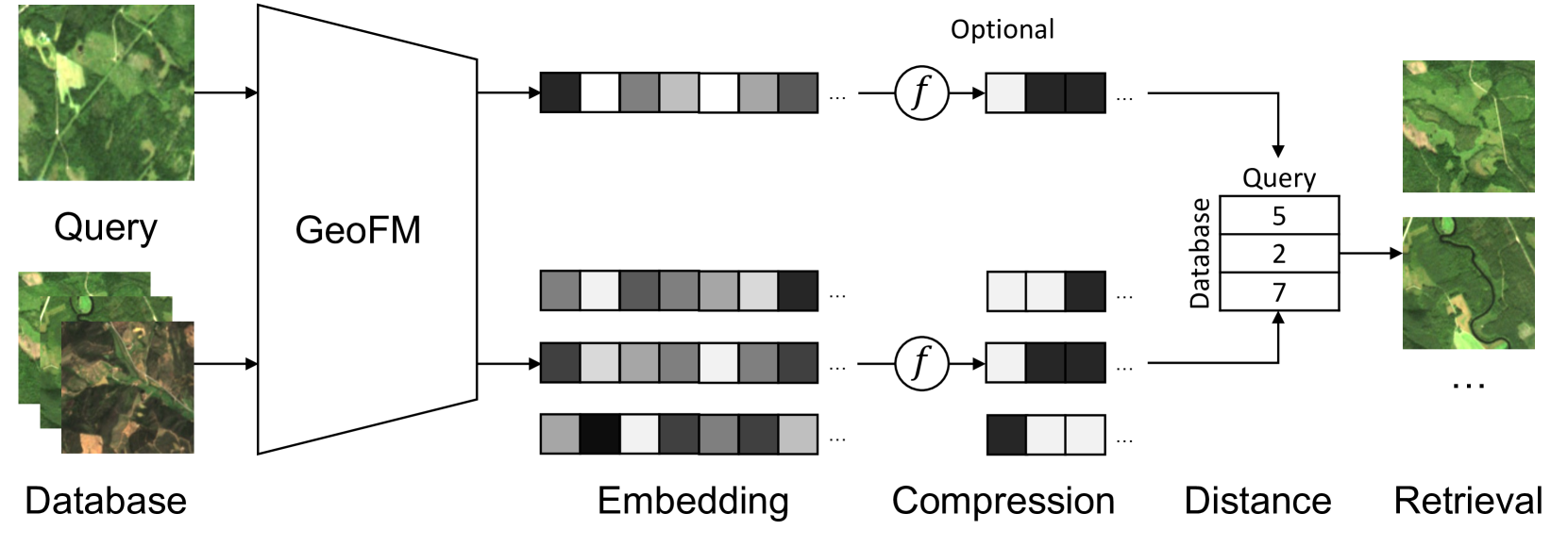
Multi-Spectral Remote Sensing Image Retrieval Using Geospatial Foundation Models
Benedikt Blumenstiel, Viktoria Moor, Romeo Kienzler, Thomas Brunschwiler
Image retrieval enables an efficient search through vast amounts of satellite imagery and returns similar images to a query. Deep learning models can identify images across various semantic concepts without the need for annotations. This work proposes to use Geospatial Foundation Models, like Prithvi, for remote sensing image retrieval with multiple benefits: i) the models encode multi-spectral satellite data and ii) generalize without further fine-tuning. We introduce two datasets to the retrieval task and observe a strong performance: Prithvi processes six bands and achieves a mean Average Precision of 97.62% on BigEarthNet-43 and 44.51% on ForestNet-12, outperforming other RGB-based models. Further, we evaluate three compression methods with binarized embeddings balancing retrieval speed and accuracy. They match the retrieval speed of much shorter hash codes while maintaining the same accuracy as floating-point embeddings but with a 32-fold compression. The code is available at https://github.com/IBM/remote-sensing-image-retrieval.
Read more5/24/2024