Topological mapping for traversability-aware long-range navigation in off-road terrain

0

Sign in to get full access
Overview
- This paper presents a topological mapping approach for long-range navigation in off-road terrain.
- The goal is to enable robots to navigate through challenging terrain while accounting for traversability constraints.
- The proposed method combines perception, planning, and mapping to build a topological map that captures the terrain's traversability.
Plain English Explanation
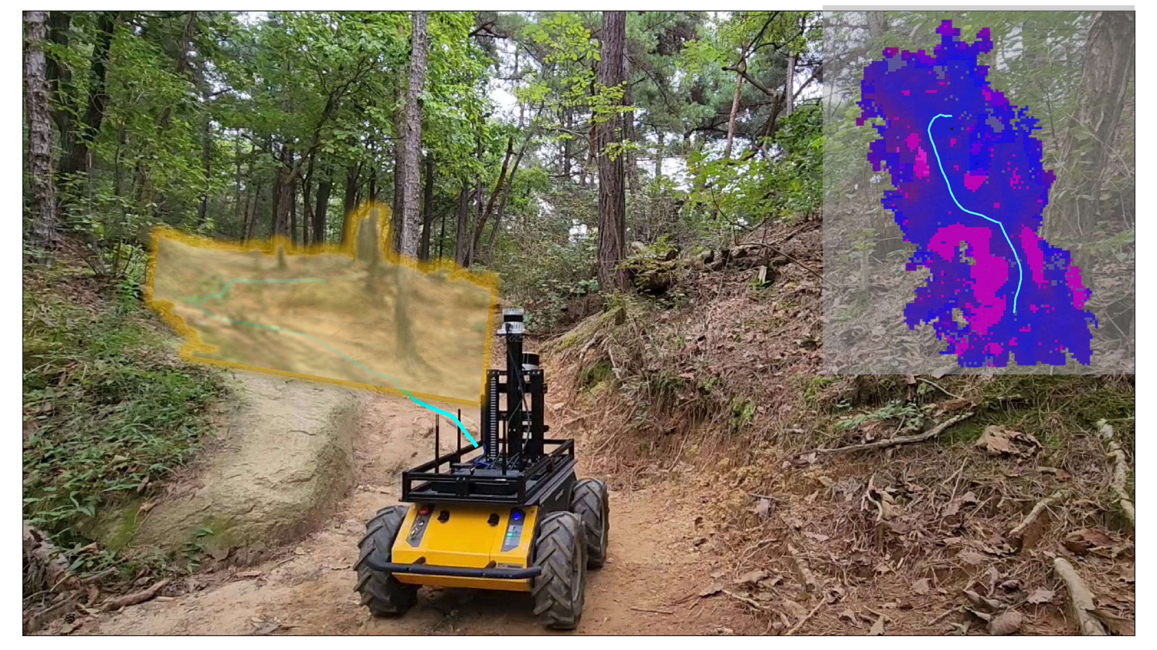
The paper describes a new way for robots to navigate through rugged outdoor environments. The key idea is to build a special type of map, called a topological map, that captures information about how easy or difficult it is to travel across different parts of the terrain.
By understanding the terrain's traversability, the robot can plan paths that avoid obstacles and challenging areas, allowing it to travel long distances safely and efficiently. This is particularly important for robots operating in natural, off-road environments, where the terrain can be highly variable and unpredictable.
The researchers combine data from the robot's sensors, such as cameras and laser scanners, with planning algorithms to construct this traversability-aware topological map. This map represents the terrain as a network of connected nodes and edges, with each edge labeled based on how easy or difficult it is to traverse.
Technical Explanation
The paper proposes a topological mapping approach for long-range navigation in off-road terrain. The key components include:
-
Perception: The robot uses a suite of sensors, such as cameras and LiDAR, to perceive the surrounding environment and extract relevant features, like terrain type, obstacles, and traversability.
-
Topological Mapping: The perceived information is used to build a topological map, which represents the environment as a graph-like structure of connected nodes and edges. Each edge is labeled with a traversability cost, reflecting the ease or difficulty of traversing that part of the terrain.
-
Planning and Control: The topological map is used to plan long-term navigation paths that avoid difficult or impassable terrain. The robot can then execute these plans while adapting its motion to the local terrain conditions.
The key innovation is the integration of traversability awareness into the topological mapping process, which allows the robot to reason about the navigability of different parts of the environment. This enables traversability-aware planning and long-range autonomous navigation in challenging off-road terrains.
Critical Analysis
The paper provides a comprehensive approach for topological mapping and traversability-aware navigation in off-road environments. However, some potential limitations and areas for future research include:
- The reliance on accurate perception of terrain features, which may be challenging in highly complex or dynamic environments.
- The need to balance the level of detail in the topological map with the computational and memory requirements for long-range planning.
- The potential for uncertainty and errors in the traversability cost estimates, which could lead to suboptimal navigation decisions.
- The applicability of the proposed approach to a wider range of robotic platforms and terrain types, beyond the specific scenarios considered in the paper.
Readers are encouraged to critically evaluate the presented research, consider the potential tradeoffs and limitations, and explore ways to further advance the state of the art in autonomous off-road navigation.
Conclusion
This paper introduces a novel topological mapping approach that integrates traversability awareness to enable long-range autonomous navigation in off-road terrains. By building a graph-like representation of the environment that captures the ease or difficulty of traversing different areas, the robot can plan paths that avoid challenging terrain and navigate efficiently over long distances.
The integration of perception, planning, and mapping techniques in this work represents an important step forward in the field of autonomous off-road robotics, with potential applications in domains such as search and rescue, environmental monitoring, and exploration.
This summary was produced with help from an AI and may contain inaccuracies - check out the links to read the original source documents!
Related Papers
0
New!Topological mapping for traversability-aware long-range navigation in off-road terrain
Jean-Franc{c}ois Tremblay, Julie Alhosh, Louis Petit, Faraz Lotfi, Lara Landauro, David Meger
Autonomous robots navigating in off-road terrain like forests open new opportunities for automation. While off-road navigation has been studied, existing work often relies on clearly delineated pathways. We present a method allowing for long-range planning, exploration and low-level control in unknown off-trail forest terrain, using vision and GPS only. We represent outdoor terrain with a topological map, which is a set of panoramic snapshots connected with edges containing traversability information. A novel traversability analysis method is demonstrated, predicting the existence of a safe path towards a target in an image. Navigating between nodes is done using goal-conditioned behavior cloning, leveraging the power of a pretrained vision transformer. An exploration planner is presented, efficiently covering an unknown off-road area with unknown traversability using a frontiers-based approach. The approach is successfully deployed to autonomously explore two 400 meters squared forest sites unseen during training, in difficult conditions for navigation.
Read more10/4/2024

0
Learning-based Traversability Costmap for Autonomous Off-road Navigation
Qiumin Zhu, Zhen Sun, Songpengcheng Xia, Guoqing Liu, Kehui Ma, Ling Pei, Zheng Gong, Cheng Jin
Traversability estimation in off-road terrains is an essential procedure for autonomous navigation. However, creating reliable labels for complex interactions between the robot and the surface is still a challenging problem in learning-based costmap generation. To address this, we propose a method that predicts traversability costmaps by leveraging both visual and geometric information of the environment. To quantify the surface properties like roughness and bumpiness, we introduce a novel way of risk-aware labelling with proprioceptive information for network training. We validate our method in costmap prediction and navigation tasks for complex off-road scenarios. Our results demonstrate that our costmap prediction method excels in terms of average accuracy and MSE. The navigation results indicate that using our learned costmaps leads to safer and smoother driving, outperforming previous methods in terms of the highest success rate, lowest normalized trajectory length, lowest time cost, and highest mean stability across two scenarios.
Read more9/17/2024

0
Autonomous Hiking Trail Navigation via Semantic Segmentation and Geometric Analysis
Camndon Reed, Christopher Tatsch, Jason N. Gross, Yu Gu
Natural environments pose significant challenges for autonomous robot navigation, particularly due to their unstructured and ever-changing nature. Hiking trails, with their dynamic conditions influenced by weather, vegetation, and human traffic, represent one such challenge. This work introduces a novel approach to autonomous hiking trail navigation that balances trail adherence with the flexibility to adapt to off-trail routes when necessary. The solution is a Traversability Analysis module that integrates semantic data from camera images with geometric information from LiDAR to create a comprehensive understanding of the surrounding terrain. A planner uses this traversability map to navigate safely, adhering to trails while allowing off-trail movement when necessary to avoid on-trail hazards or for safe off-trail shortcuts. The method is evaluated through simulation to determine the balance between semantic and geometric information in traversability estimation. These simulations tested various weights to assess their impact on navigation performance across different trail scenarios. Weights were then validated through field tests at the West Virginia University Core Arboretum, demonstrating the method's effectiveness in a real-world environment.
Read more9/25/2024
0
Traversability-aware Adaptive Optimization for Path Planning and Control in Mountainous Terrain
Se-Wook Yoo, E In Son, Seung-Woo Seo
Autonomous navigation in extreme mountainous terrains poses challenges due to the presence of mobility-stressing elements and undulating surfaces, making it particularly difficult compared to conventional off-road driving scenarios. In such environments, estimating traversability solely based on exteroceptive sensors often leads to the inability to reach the goal due to a high prevalence of non-traversable areas. In this paper, we consider traversability as a relative value that integrates the robot's internal state, such as speed and torque to exhibit resilient behavior to reach its goal successfully. We separate traversability into apparent traversability and relative traversability, then incorporate these distinctions in the optimization process of sampling-based planning and motion predictive control. Our method enables the robots to execute the desired behaviors more accurately while avoiding hazardous regions and getting stuck. Experiments conducted on simulation with 27 diverse types of mountainous terrain and real-world demonstrate the robustness of the proposed framework, with increasingly better performance observed in more complex environments.
Read more4/5/2024