Towards introspective loop closure in 4D radar SLAM
2404.03940
0
0
Abstract
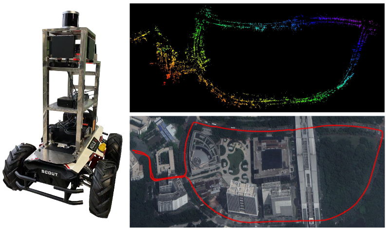
Imaging radar is an emerging sensor modality in the context of Localization and Mapping (SLAM), especially suitable for vision-obstructed environments. This article investigates the use of 4D imaging radars for SLAM and analyzes the challenges in robust loop closure. Previous work indicates that 4D radars, together with inertial measurements, offer ample information for accurate odometry estimation. However, the low field of view, limited resolution, and sparse and noisy measurements render loop closure a significantly more challenging problem. Our work builds on the previous work - TBV SLAM - which was proposed for robust loop closure with 360$^circ$ spinning radars. This article highlights and addresses challenges inherited from a directional 4D radar, such as sparsity, noise, and reduced field of view, and discusses why the common definition of a loop closure is unsuitable. By combining multiple quality measures for accurate loop closure detection adapted to 4D radar data, significant results in trajectory estimation are achieved; the absolute trajectory error is as low as 0.46 m over a distance of 1.8 km, with consistent operation over multiple environments.
Create account to get full access
Overview
- Presents a novel approach for loop closure detection in 4D radar SLAM (Simultaneous Localization and Mapping) using "introspective" techniques.
- Leverages the unique properties of 4D radar data, including Doppler velocity measurements, to enhance loop closure detection.
- Explores methods to improve the robustness and reliability of 4D radar SLAM systems.
Plain English Explanation
This research paper focuses on improving the loop closure detection in Simultaneous Localization and Mapping (SLAM) systems that use 4D radar data. SLAM is a technique used by robots and autonomous vehicles to build a map of their surroundings and localize themselves within that map. Loop closure detection is a crucial step in SLAM, as it helps the system recognize when it has revisited a previously explored area, which is essential for maintaining an accurate map.
The researchers propose an "introspective" approach to loop closure detection, which means the system analyzes its own data and internal states to identify potential loop closures. This is particularly important for 4D radar data, which includes information about the velocity of objects in addition to their position. By leveraging this additional Doppler velocity data, the researchers aim to enhance the robustness and reliability of the loop closure detection process.
The paper explores various techniques and algorithms to effectively utilize the 4D radar data for loop closure detection, with the goal of creating more accurate and reliable SLAM systems. This could have significant implications for the development of autonomous vehicles, robotics, and other applications that rely on accurate mapping and localization.
Technical Explanation
The paper presents a novel approach for loop closure detection in 4D radar SLAM systems. 4D radar, which provides both spatial and Doppler velocity information, can offer unique advantages over traditional 2D or 3D SLAM systems that rely solely on spatial data. Towards long-term SLAM with thermal imagery and BundledSLAM: Accurate visual SLAM system using multiple have explored similar concepts in the context of thermal and visual SLAM, respectively.
The key innovation in this work is the use of "introspective" techniques to analyze the 4D radar data and internal states of the SLAM system to identify potential loop closures. This approach aims to leverage the unique properties of 4D radar, such as Doppler velocity measurements, to enhance the robustness and reliability of the loop closure detection process.
The researchers evaluate their approach using real-world datasets and compare it to traditional spatial-only SLAM methods. Advancements in radar odometry and Are Doppler velocity measurements useful for spinning radar? provide relevant context on the state-of-the-art in radar-based SLAM.
The results demonstrate the potential benefits of the introspective loop closure approach, particularly in challenging environments where traditional methods may struggle. The researchers also discuss the limitations of their approach and identify areas for future research, such as the integration of additional sensor modalities and the development of more sophisticated introspective algorithms.
Critical Analysis
The paper presents a promising approach for enhancing loop closure detection in 4D radar SLAM systems. The use of introspective techniques to leverage the unique properties of 4D radar data, such as Doppler velocity measurements, is a novel and interesting concept. Versatile lidar-inertial odometry with SE(2) constraints explores similar ideas in the context of lidar-inertial SLAM.
One potential limitation of the proposed approach is the reliance on high-quality 4D radar data, which may not be readily available in all real-world scenarios. The researchers acknowledge this and suggest the need for further investigation into the robustness of their methods under different environmental conditions and sensor configurations.
Additionally, the paper does not provide a comprehensive comparison to other state-of-the-art 4D radar SLAM techniques, which could help to better contextualize the performance and advantages of the introspective approach. Further evaluation and benchmarking against a wider range of algorithms and datasets would strengthen the claims made in the paper.
Overall, the research presents an interesting and potentially impactful contribution to the field of 4D radar SLAM. The introspective loop closure detection approach warrants further exploration and development, particularly in the integration with other sensor modalities and the continued refinement of the underlying algorithms.
Conclusion
This paper introduces a novel approach for enhancing loop closure detection in 4D radar SLAM systems using introspective techniques. By leveraging the unique properties of 4D radar data, including Doppler velocity measurements, the researchers aim to improve the robustness and reliability of SLAM systems in challenging environments.
The proposed introspective approach demonstrates promising results, suggesting that the integration of additional data sources and more sophisticated introspective algorithms could lead to significant advancements in the field of 4D radar SLAM. As autonomous vehicles, robotics, and other applications continue to rely on accurate mapping and localization, this research represents an important step forward in developing more reliable and capable SLAM systems.
This summary was produced with help from an AI and may contain inaccuracies - check out the links to read the original source documents!
Related Papers

2DLIW-SLAM:2D LiDAR-Inertial-Wheel Odometry with Real-Time Loop Closure
Bin Zhang, Zexin Peng, Bi Zeng, Junjie Lu
0
0
Due to budgetary constraints, indoor navigation typically employs 2D LiDAR rather than 3D LiDAR. However, the utilization of 2D LiDAR in Simultaneous Localization And Mapping (SLAM) frequently encounters challenges related to motion degeneracy, particularly in geometrically similar environments. To address this problem, this paper proposes a robust, accurate, and multi-sensor-fused 2D LiDAR SLAM system specifically designed for indoor mobile robots. To commence, the original LiDAR data undergoes meticulous processing through point and line extraction. Leveraging the distinctive characteristics of indoor environments, line-line constraints are established to complement other sensor data effectively, thereby augmenting the overall robustness and precision of the system. Concurrently, a tightly-coupled front-end is created, integrating data from the 2D LiDAR, IMU, and wheel odometry, thus enabling real-time state estimation. Building upon this solid foundation, a novel global feature point matching-based loop closure detection algorithm is proposed. This algorithm proves highly effective in mitigating front-end accumulated errors and ultimately constructs a globally consistent map. The experimental results indicate that our system fully meets real-time requirements. When compared to Cartographer, our system not only exhibits lower trajectory errors but also demonstrates stronger robustness, particularly in degeneracy problem.
4/24/2024
🔮
RadarOcc: Robust 3D Occupancy Prediction with 4D Imaging Radar
Fangqiang Ding, Xiangyu Wen, Lawrence Zhu, Yiming Li, Chris Xiaoxuan Lu
0
0
3D occupancy-based perception pipeline has significantly advanced autonomous driving by capturing detailed scene descriptions and demonstrating strong generalizability across various object categories and shapes. Current methods predominantly rely on LiDAR or camera inputs for 3D occupancy prediction. These methods are susceptible to adverse weather conditions, limiting the all-weather deployment of self-driving cars. To improve perception robustness, we leverage the recent advances in automotive radars and introduce a novel approach that utilizes 4D imaging radar sensors for 3D occupancy prediction. Our method, RadarOcc, circumvents the limitations of sparse radar point clouds by directly processing the 4D radar tensor, thus preserving essential scene details. RadarOcc innovatively addresses the challenges associated with the voluminous and noisy 4D radar data by employing Doppler bins descriptors, sidelobe-aware spatial sparsification, and range-wise self-attention mechanisms. To minimize the interpolation errors associated with direct coordinate transformations, we also devise a spherical-based feature encoding followed by spherical-to-Cartesian feature aggregation. We benchmark various baseline methods based on distinct modalities on the public K-Radar dataset. The results demonstrate RadarOcc's state-of-the-art performance in radar-based 3D occupancy prediction and promising results even when compared with LiDAR- or camera-based methods. Additionally, we present qualitative evidence of the superior performance of 4D radar in adverse weather conditions and explore the impact of key pipeline components through ablation studies.
6/14/2024
🎲
Radarize: Enhancing Radar SLAM with Generalizable Doppler-Based Odometry
Emerson Sie, Xinyu Wu, Heyu Guo, Deepak Vasisht
0
0
Millimeter-wave (mmWave) radar is increasingly being considered as an alternative to optical sensors for robotic primitives like simultaneous localization and mapping (SLAM). While mmWave radar overcomes some limitations of optical sensors, such as occlusions, poor lighting conditions, and privacy concerns, it also faces unique challenges, such as missed obstacles due to specular reflections or fake objects due to multipath. To address these challenges, we propose Radarize, a self-contained SLAM pipeline that uses only a commodity single-chip mmWave radar. Our radar-native approach uses techniques such as Doppler shift-based odometry and multipath artifact suppression to improve performance. We evaluate our method on a large dataset of 146 trajectories spanning 4 buildings and mounted on 3 different platforms, totaling approximately 4.7 Km of travel distance. Our results show that our method outperforms state-of-the-art radar and radar-inertial approaches by approximately 5x in terms of odometry and 8x in terms of end-to-end SLAM, as measured by absolute trajectory error (ATE), without the need for additional sensors such as IMUs or wheel encoders.
4/30/2024
EFEAR-4D: Ego-Velocity Filtering for Efficient and Accurate 4D radar Odometry
Xiaoyi Wu, Yushuai Chen, Zhan Li, Ziyang Hong, Liang Hu
0
0
Odometry is a crucial component for successfully implementing autonomous navigation, relying on sensors such as cameras, LiDARs and IMUs. However, these sensors may encounter challenges in extreme weather conditions, such as snowfall and fog. The emergence of FMCW radar technology offers the potential for robust perception in adverse conditions. As the latest generation of FWCW radars, the 4D mmWave radar provides point cloud with range, azimuth, elevation, and Doppler velocity information, despite inherent sparsity and noises in the point cloud. In this paper, we propose EFEAR-4D, an accurate, highly efficient, and learning-free method for large-scale 4D radar odometry estimation. EFEAR-4D exploits Doppler velocity information delicately for robust ego-velocity estimation, resulting in a highly accurate prior guess. EFEAR-4D maintains robustness against point-cloud sparsity and noises across diverse environments through dynamic object removal and effective region-wise feature extraction. Extensive experiments on two publicly available 4D radar datasets demonstrate state-of-the-art reliability and localization accuracy of EFEAR-4D under various conditions. Furthermore, we have collected a dataset following the same route but varying installation heights of the 4D radar, emphasizing the significant impact of radar height on point cloud quality - a crucial consideration for real-world deployments. Our algorithm and dataset will be available soon at https://github.com/CLASS-Lab/EFEAR-4D.
5/17/2024