Towards Temporal Change Explanations from Bi-Temporal Satellite Images

0

Sign in to get full access
Overview
- This paper proposes a method for explaining temporal changes in satellite imagery using a bi-temporal analysis approach.
- The method aims to provide interpretable explanations of the changes observed between two satellite images captured at different time points.
- The approach leverages deep learning techniques to extract and analyze relevant features from the satellite images to identify and explain the underlying causes of the observed changes.
Plain English Explanation
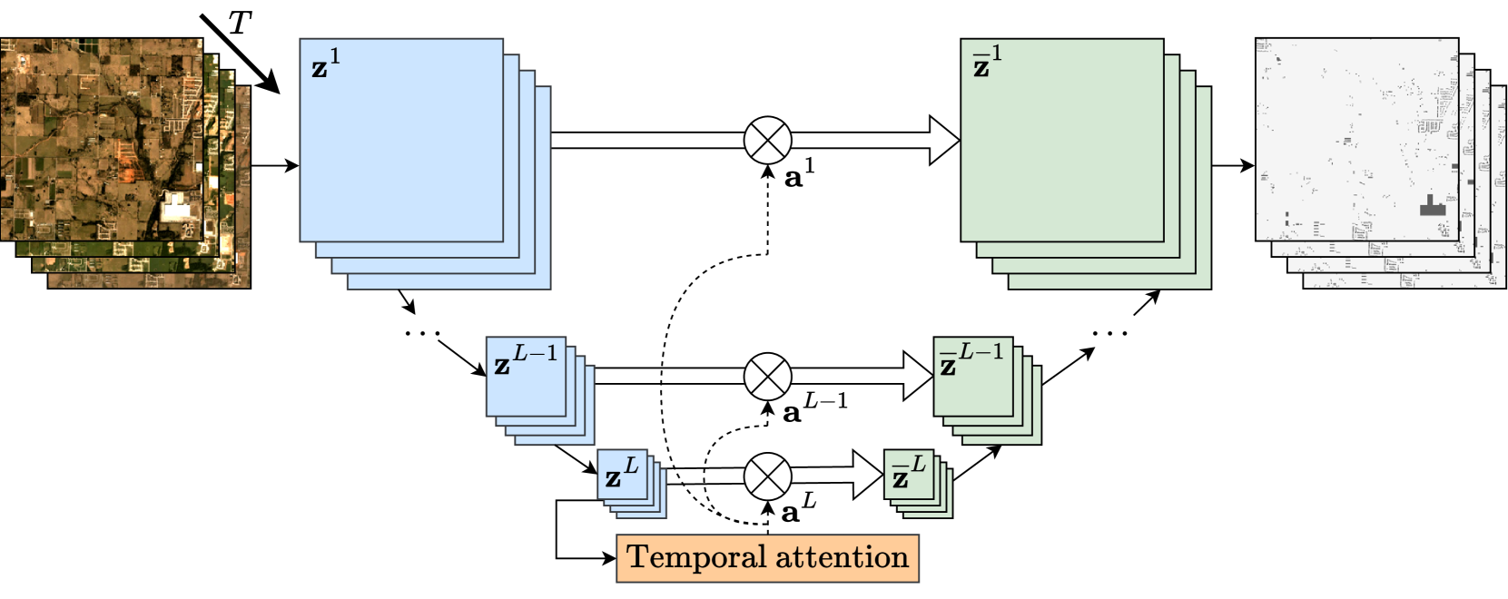
Satellite images can be used to monitor changes in the world over time, such as the growth of cities, deforestation, or the impacts of natural disasters. However, it can be challenging to understand the specific reasons for these changes just by looking at the images. <a href="https://aimodels.fyi/papers/arxiv/towards-multimodal-framework-remote-sensing-image-change">This research proposes a new method to help explain the causes of the changes observed in satellite imagery over time</a>.
The key idea is to analyze two satellite images captured at different time points and identify the specific regions or features that have changed between the two time points. The method uses advanced machine learning techniques to extract and analyze relevant information from the images, such as the shapes, textures, and colors of different objects and land features. By understanding how these features have changed, the method can then provide explanations for the underlying reasons behind the observed changes, such as new construction, vegetation growth, or natural disasters.
This type of temporal change explanation could be very useful for a variety of applications, such as urban planning, environmental monitoring, or disaster response. <a href="https://aimodels.fyi/papers/arxiv/temporal-grounding-activities-using-multimodal-large-language">It can help decision-makers and researchers better understand the dynamics of a region over time and take appropriate actions</a>.
Technical Explanation
The proposed method for temporal change explanation from bi-temporal satellite images consists of several key components:
-
Image Preprocessing: The method begins by preprocessing the satellite images to align them spatially and adjust for any differences in lighting, resolution, or other factors that may have changed between the two time points.
-
Feature Extraction: Deep learning models are used to extract relevant visual features from the satellite images, such as land cover types, building structures, and transportation networks. <a href="https://aimodels.fyi/papers/arxiv/satellite-image-time-series-semantic-change-detection">These features are then compared between the two time points to identify areas that have changed</a>.
-
Change Detection: The method uses change detection algorithms to identify the specific regions or features that have changed between the two satellite images. This includes both quantitative measures of the degree of change as well as qualitative descriptions of the types of changes observed.
-
Explanation Generation: Finally, the method generates interpretable explanations for the detected changes by analyzing the extracted features and their temporal evolution. <a href="https://aimodels.fyi/papers/arxiv/vision-language-models-remote-sensing-current-progress">This involves mapping the observed changes to higher-level semantic concepts and providing natural language descriptions of the underlying causes</a>.
The authors evaluate the proposed method on several real-world satellite image datasets and demonstrate its effectiveness in providing intuitive and meaningful explanations of the observed temporal changes.
Critical Analysis
The key strengths of this research are its focus on providing interpretable and explainable temporal change analysis from satellite imagery, as well as its potential for a wide range of practical applications. By moving beyond simply detecting changes to also explaining their underlying causes, the method has the potential to significantly enhance our understanding of complex real-world dynamics.
However, the paper also acknowledges some important limitations and areas for future work. For example, the method currently relies on pre-defined feature extraction models, which may not capture all relevant aspects of the observed changes. <a href="https://aimodels.fyi/papers/arxiv/enhancing-robot-explanation-capabilities-through-vision-language">Exploring more flexible and adaptive feature extraction approaches could help improve the accuracy and granularity of the generated explanations</a>.
Additionally, the paper notes that the method's performance may be sensitive to factors such as image quality, spatial resolution, and the specific types of changes being analyzed. Further research is needed to understand the robustness of the approach and how it might be adapted to different application domains and data sources.
Overall, this research represents an important step forward in the field of temporal change analysis from satellite imagery, and the proposed method has the potential to significantly enhance our understanding of complex real-world dynamics. However, continued research and development will be needed to fully realize its practical potential.
Conclusion
This paper presents a novel method for providing interpretable explanations of temporal changes observed in satellite imagery. By leveraging advanced deep learning techniques for feature extraction and change detection, the method can identify and describe the underlying causes of changes between two satellite images captured at different time points.
The potential applications of this research are diverse, ranging from urban planning and environmental monitoring to disaster response and humanitarian aid. <a href="https://aimodels.fyi/papers/arxiv/towards-multimodal-framework-remote-sensing-image-change">By enabling more nuanced and contextual understanding of the observed changes, the method could help decision-makers and researchers make more informed decisions and take more targeted actions</a>.
While the current approach has some limitations, the authors have outlined several promising directions for future research and development. As the field of remote sensing and satellite imagery analysis continues to evolve, methods like the one proposed in this paper will become increasingly crucial for extracting meaningful insights and driving real-world impact.
This summary was produced with help from an AI and may contain inaccuracies - check out the links to read the original source documents!
Related Papers
0
Towards Temporal Change Explanations from Bi-Temporal Satellite Images
Ryo Tsujimoto, Hiroki Ouchi, Hidetaka Kamigaito, Taro Watanabe
Explaining temporal changes between satellite images taken at different times is important for urban planning and environmental monitoring. However, manual dataset construction for the task is costly, so human-AI collaboration is promissing. Toward the direction, in this paper, we investigate the ability of Large-scale Vision-Language Models (LVLMs) to explain temporal changes between satellite images. While LVLMs are known to generate good image captions, they receive only a single image as input. To deal with a par of satellite images as input, we propose three prompting methods. Through human evaluation, we found the effectiveness of our step-by-step reasoning based prompting.
Read more7/16/2024

0
Towards a multimodal framework for remote sensing image change retrieval and captioning
Roger Ferrod, Luigi Di Caro, Dino Ienco
Recently, there has been increasing interest in multimodal applications that integrate text with other modalities, such as images, audio and video, to facilitate natural language interactions with multimodal AI systems. While applications involving standard modalities have been extensively explored, there is still a lack of investigation into specific data modalities such as remote sensing (RS) data. Despite the numerous potential applications of RS data, including environmental protection, disaster monitoring and land planning, available solutions are predominantly focused on specific tasks like classification, captioning and retrieval. These solutions often overlook the unique characteristics of RS data, such as its capability to systematically provide information on the same geographical areas over time. This ability enables continuous monitoring of changes in the underlying landscape. To address this gap, we propose a novel foundation model for bi-temporal RS image pairs, in the context of change detection analysis, leveraging Contrastive Learning and the LEVIR-CC dataset for both captioning and text-image retrieval. By jointly training a contrastive encoder and captioning decoder, our model add text-image retrieval capabilities, in the context of bi-temporal change detection, while maintaining captioning performances that are comparable to the state of the art. We release the source code and pretrained weights at: https://github.com/rogerferrod/RSICRC.
Read more6/21/2024

0
Temporal Grounding of Activities using Multimodal Large Language Models
Young Chol Song
Temporal grounding of activities, the identification of specific time intervals of actions within a larger event context, is a critical task in video understanding. Recent advancements in multimodal large language models (LLMs) offer new opportunities for enhancing temporal reasoning capabilities. In this paper, we evaluate the effectiveness of combining image-based and text-based large language models (LLMs) in a two-stage approach for temporal activity localization. We demonstrate that our method outperforms existing video-based LLMs. Furthermore, we explore the impact of instruction-tuning on a smaller multimodal LLM, showing that refining its ability to process action queries leads to more expressive and informative outputs, thereby enhancing its performance in identifying specific time intervals of activities. Our experimental results on the Charades-STA dataset highlight the potential of this approach in advancing the field of temporal activity localization and video understanding.
Read more7/9/2024
0
Satellite Image Time Series Semantic Change Detection: Novel Architecture and Analysis of Domain Shift
Elliot Vincent, Jean Ponce, Mathieu Aubry
Satellite imagery plays a crucial role in monitoring changes happening on Earth's surface and aiding in climate analysis, ecosystem assessment, and disaster response. In this paper, we tackle semantic change detection with satellite image time series (SITS-SCD) which encompasses both change detection and semantic segmentation tasks. We propose a new architecture that improves over the state of the art, scales better with the number of parameters, and leverages long-term temporal information. However, for practical use cases, models need to adapt to spatial and temporal shifts, which remains a challenge. We investigate the impact of temporal and spatial shifts separately on global, multi-year SITS datasets using DynamicEarthNet and MUDS. We show that the spatial domain shift represents the most complex setting and that the impact of temporal shift on performance is more pronounced on change detection than on semantic segmentation, highlighting that it is a specific issue deserving further attention.
Read more7/11/2024