Tree semantic segmentation from aerial image time series

0
Sign in to get full access
Overview
- This paper proposes a method for semantic segmentation of trees from aerial image time series data.
- The authors develop a deep learning-based approach that leverages the temporal information in multi-temporal aerial imagery to improve tree segmentation performance.
- The method is evaluated on a dataset of aerial images collected over a forested area, and the results demonstrate improved accuracy compared to existing tree segmentation techniques.
Plain English Explanation
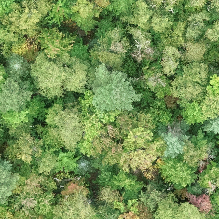
The paper describes a way to automatically identify individual trees in aerial photographs taken over time. This is a challenging task because trees can look quite similar to each other, and their appearance can change as they grow and the seasons change. The researchers developed a deep learning model that takes a series of aerial images captured at different times and uses the information in all of them to better distinguish individual trees.
By looking at how each tree's appearance changes over time, the model can more accurately segment the image and label each tree. This is an important capability for applications like forest management, urban planning, and precision agriculture. The authors test their approach on a dataset of aerial images of a forested area and show that it outperforms other tree segmentation methods.
Technical Explanation
The paper introduces a deep learning-based approach for semantic segmentation of trees from aerial image time series data. The key innovation is the use of a recurrent neural network (RNN) architecture that can capture the temporal evolution of tree appearances across the input image sequence.
The proposed model takes a series of co-registered aerial images as input and outputs a pixel-wise segmentation mask labeling each tree in the scene. The RNN component allows the model to integrate information from multiple time steps to improve the segmentation accuracy, compared to processing each image independently.
The model is evaluated on a dataset of aerial images collected over a forested area, and the results demonstrate significant improvements in tree segmentation performance compared to baseline methods that do not leverage the temporal information, such as SegForestNet and ClassifyingGeoSpatialObjects. The authors also provide an ablation study to analyze the contribution of the RNN component to the overall performance.
Critical Analysis
The paper presents a promising approach for leveraging temporal information in aerial imagery to improve tree segmentation, which is an important capability for various geospatial applications. However, the authors acknowledge several limitations and areas for future work.
One potential issue is the reliance on co-registered aerial image sequences, which may not always be available in real-world scenarios. The authors suggest exploring ways to handle misaligned or incomplete image time series as a direction for future research.
Additionally, the evaluation is conducted on a relatively small dataset of a single forested area, and it would be valuable to test the method's generalization to more diverse environments, such as urban settings or plantation forests.
Finally, the paper does not provide a detailed analysis of the computational complexity or inference time of the proposed approach, which could be an important consideration for real-time applications.
Conclusion
This paper presents a novel deep learning-based method for semantic segmentation of trees from aerial image time series data. By leveraging the temporal information in the input image sequence, the proposed approach demonstrates improved tree segmentation accuracy compared to existing techniques. The work has promising implications for a range of geospatial applications, such as forest management, urban planning, and precision agriculture, where accurate tree detection and monitoring are crucial. While the paper highlights several limitations and areas for future research, the overall approach represents a valuable contribution to the field of remote sensing and computer vision.
This summary was produced with help from an AI and may contain inaccuracies - check out the links to read the original source documents!
Related Papers
0
Tree semantic segmentation from aerial image time series
Venkatesh Ramesh, Arthur Ouaknine, David Rolnick
Earth's forests play an important role in the fight against climate change, and are in turn negatively affected by it. Effective monitoring of different tree species is essential to understanding and improving the health and biodiversity of forests. In this work, we address the challenge of tree species identification by performing semantic segmentation of trees using an aerial image dataset spanning over a year. We compare models trained on single images versus those trained on time series to assess the impact of tree phenology on segmentation performances. We also introduce a simple convolutional block for extracting spatio-temporal features from image time series, enabling the use of popular pretrained backbones and methods. We leverage the hierarchical structure of tree species taxonomy by incorporating a custom loss function that refines predictions at three levels: species, genus, and higher-level taxa. Our findings demonstrate the superiority of our methodology in exploiting the time series modality and confirm that enriching labels using taxonomic information improves the semantic segmentation performance.
Read more7/19/2024
🏷️
0
Tree species classification at the pixel-level using deep learning and multispectral time series in an imbalanced context
Florian Mouret (CESBIO, UO), David Morin (CESBIO), Milena Planells (CESBIO), C'ecile Vincent-Barbaroux
This paper investigates tree species classification using Sentinel-2 multispectral satellite image time-series. Despite their critical importance for many applications, such maps are often unavailable, outdated, or inaccurate for large areas. The interest of using remote sensing time series to produce these maps has been highlighted in many studies. However, many methods proposed in the literature still rely on a standard classification algorithm, usually the Random Forest (RF) algorithm with vegetation indices. This study shows that the use of deep learning models can lead to a significant improvement in classification results, especially in an imbalanced context where the RF algorithm tends to predict towards the majority class. In our use case in the center of France with 10 tree species, we obtain an overall accuracy (OA) around 95% and a F1-macro score around 80% using three different benchmark deep learning architectures. In contrast, using the RF algorithm yields an OA of 93% and an F1 of 60%, indicating that the minority classes are not classified with sufficient accuracy. Therefore, the proposed framework is a strong baseline that can be easily implemented in most scenarios, even with a limited amount of reference data. Our results highlight that standard multilayer perceptron can be competitive with batch normalization and a sufficient amount of parameters. Other architectures (convolutional or attention-based) can also achieve strong results when tuned properly. Furthermore, our results show that DL models are naturally robust to imbalanced data, although similar results can be obtained using dedicated techniques.
Read more8/20/2024

0
Plant detection from ultra high resolution remote sensing images: A Semantic Segmentation approach based on fuzzy loss
Shivam Pande, Baki Uzun, Florent Guiotte, Thomas Corpetti, Florian Delerue, S'ebastien Lef`evre
In this study, we tackle the challenge of identifying plant species from ultra high resolution (UHR) remote sensing images. Our approach involves introducing an RGB remote sensing dataset, characterized by millimeter-level spatial resolution, meticulously curated through several field expeditions across a mountainous region in France covering various landscapes. The task of plant species identification is framed as a semantic segmentation problem for its practical and efficient implementation across vast geographical areas. However, when dealing with segmentation masks, we confront instances where distinguishing boundaries between plant species and their background is challenging. We tackle this issue by introducing a fuzzy loss within the segmentation model. Instead of utilizing one-hot encoded ground truth (GT), our model incorporates Gaussian filter refined GT, introducing stochasticity during training. First experimental results obtained on both our UHR dataset and a public dataset are presented, showing the relevance of the proposed methodology, as well as the need for future improvement.
Read more9/4/2024

0
Towards general deep-learning-based tree instance segmentation models
Jonathan Henrich, Jan van Delden
The segmentation of individual trees from forest point clouds is a crucial task for downstream analyses such as carbon sequestration estimation. Recently, deep-learning-based methods have been proposed which show the potential of learning to segment trees. Since these methods are trained in a supervised way, the question arises how general models can be obtained that are applicable across a wide range of settings. So far, training has been mainly conducted with data from one specific laser scanning type and for specific types of forests. In this work, we train one segmentation model under various conditions, using seven diverse datasets found in literature, to gain insights into the generalization capabilities under domain-shift. Our results suggest that a generalization from coniferous dominated sparse point clouds to deciduous dominated high-resolution point clouds is possible. Conversely, qualitative evidence suggests that generalization from high-resolution to low-resolution point clouds is challenging. This emphasizes the need for forest point clouds with diverse data characteristics for model development. To enrich the available data basis, labeled trees from two previous works were propagated to the complete forest point cloud and are made publicly available at https://doi.org/10.25625/QUTUWU.
Read more5/6/2024