Constructing a High Temporal Resolution Global Lakes Dataset via Swin-Unet with Applications to Area Prediction

0
Sign in to get full access
Overview
- Constructed a high temporal resolution global lakes dataset using Swin-Unet, a deep learning model for semantic segmentation
- Applied the dataset to predict lake areas over time, demonstrating its potential for various applications
Plain English Explanation
The researchers in this study aimed to create a detailed global dataset of lakes and their areas over time. To do this, they used a deep learning model called Swin-Unet to analyze satellite imagery and identify the locations and sizes of lakes around the world.
The Swin-Unet model is particularly good at semantic segmentation, which means it can accurately classify different objects, like lakes, in an image. The researchers trained this model on a large dataset of satellite images and lake outlines to teach it how to recognize lakes.
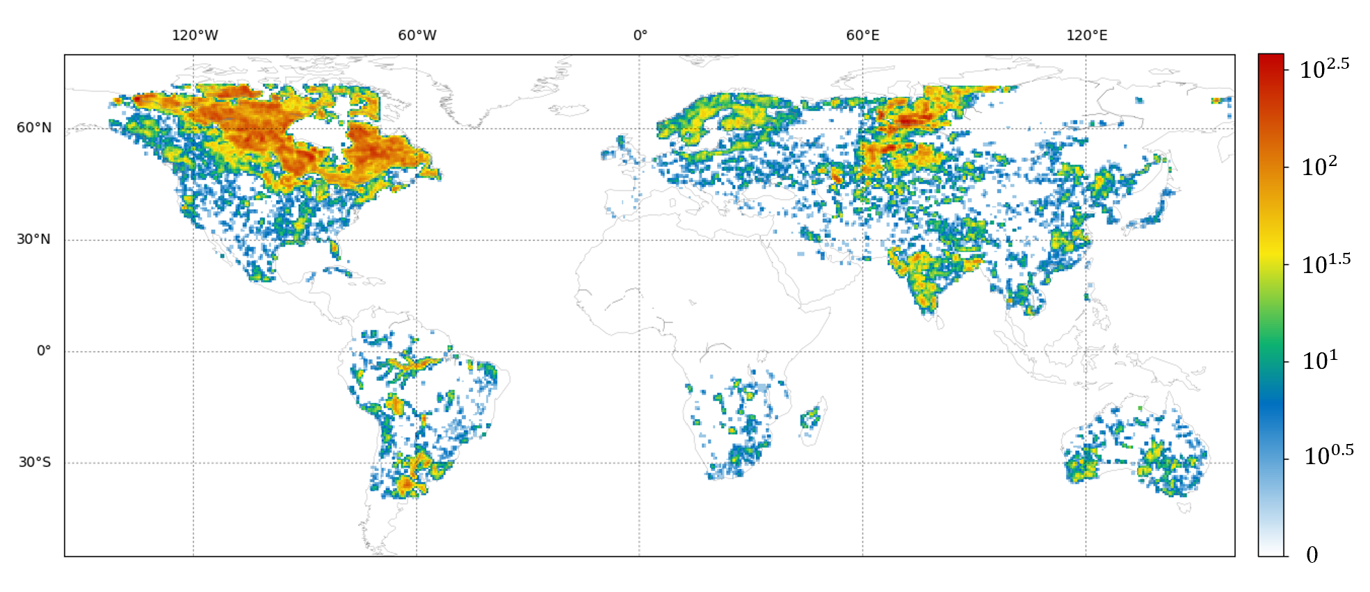
Once the model was trained, the researchers applied it to analyze Google Earth Engine satellite data covering the entire globe. This allowed them to create a comprehensive dataset of lake locations and sizes over multiple years, providing a high temporal resolution view of how lakes are changing over time.
The researchers then demonstrated how this dataset could be used to predict future lake areas, which could be valuable for managing water resources and understanding the impacts of climate change. Overall, this research provides a powerful tool for studying the Earth's water bodies and their dynamics.
Technical Explanation
The researchers developed a method to create a high temporal resolution global lakes dataset using the Swin-Unet deep learning model for semantic segmentation. Swin-Unet is an advanced convolutional neural network architecture that is well-suited for accurately identifying and delineating objects, like lakes, in satellite imagery.
The researchers first trained the Swin-Unet model on a dataset of satellite images and corresponding lake outlines. This allowed the model to learn the visual patterns and characteristics of lakes, enabling it to accurately segment them in new imagery.
The trained Swin-Unet model was then applied to process Google Earth Engine satellite data covering the entire globe over multiple years. This generated a comprehensive dataset of lake locations and sizes at a high temporal resolution, with observations taken at frequent intervals.
To demonstrate the value of this dataset, the researchers used it to train a time series forecasting model to predict future lake areas. This shows how the high-quality lake dataset can be leveraged for applications like water resource management and understanding the impacts of climate change on water bodies.
Critical Analysis
The researchers acknowledge several limitations in their study. First, the training data for the Swin-Unet model was primarily focused on larger lakes, so the model's performance may be less accurate for smaller water bodies. Additionally, cloud cover and other environmental factors can introduce noise and challenges in the satellite imagery, which may impact the model's ability to precisely delineate lake boundaries.
The researchers also note that the time series forecasting model used to predict future lake areas has inherent uncertainties, and further work is needed to improve the accuracy of these predictions. Validating the dataset against ground-truth measurements would also help to quantify its reliability and identify any systematic biases.
While the researchers demonstrate the potential applications of this dataset, it would be valuable to see more case studies and real-world use cases to fully assess its practical value and impact. Exploring the dataset's integration with other environmental data sources could also uncover additional insights and applications.
Conclusion
This study presents a novel approach to constructing a high-quality, high-temporal-resolution global lakes dataset using deep learning. The resulting dataset has the potential to enable a wide range of applications, from water resource management to understanding the impacts of climate change on water bodies.
By leveraging advanced techniques like Swin-Unet for semantic segmentation, the researchers have created a valuable tool for the scientific community and policymakers. Further refinement and validation of the dataset, as well as exploration of its integration with other data sources, could lead to even greater insights and impacts in the future.
This summary was produced with help from an AI and may contain inaccuracies - check out the links to read the original source documents!
Related Papers
0
Constructing a High Temporal Resolution Global Lakes Dataset via Swin-Unet with Applications to Area Prediction
Yutian Han, Baoxiang Huang, He Gao
Lakes provide a wide range of valuable ecosystem services, such as water supply, biodiversity habitats, and carbon sequestration. However, lakes are increasingly threatened by climate change and human activities. Therefore, continuous global monitoring of lake dynamics is crucial, but remains challenging on a large scale. The recently developed Global Lakes Area Database (GLAKES) has mapped over 3.4 million lakes worldwide, but it only provides data at decadal intervals, which may be insufficient to capture rapid or short-term changes.This paper introduces an expanded lake database, GLAKES-Additional, which offers biennial delineations and area measurements for 152,567 lakes globally from 1990 to 2021. We employed the Swin-Unet model, replacing traditional convolution operations, to effectively address the challenges posed by the receptive field requirements of high spatial resolution satellite imagery. The increased biennial time resolution helps to quantitatively attribute lake area changes to climatic and hydrological drivers, such as precipitation and temperature changes.For predicting lake area changes, we used a Long Short-Term Memory (LSTM) neural network and an extended time series dataset for preliminary modeling. Under climate and land use scenarios, our model achieved an RMSE of 0.317 km^2 in predicting future lake area changes.
Read more8/21/2024

0
Towards Global Glacier Mapping with Deep Learning and Open Earth Observation Data
Konstantin A. Maslov, Claudio Persello, Thomas Schellenberger, Alfred Stein
Accurate global glacier mapping is critical for understanding climate change impacts. Despite its importance, automated glacier mapping at a global scale remains largely unexplored. Here we address this gap and propose Glacier-VisionTransformer-U-Net (GlaViTU), a convolutional-transformer deep learning model, and five strategies for multitemporal global-scale glacier mapping using open satellite imagery. Assessing the spatial, temporal and cross-sensor generalisation shows that our best strategy achieves intersection over union >0.85 on previously unobserved images in most cases, which drops to >0.75 for debris-rich areas such as High-Mountain Asia and increases to >0.90 for regions dominated by clean ice. A comparative validation against human expert uncertainties in terms of area and distance deviations underscores GlaViTU performance, approaching or matching expert-level delineation. Adding synthetic aperture radar data, namely, backscatter and interferometric coherence, increases the accuracy in all regions where available. The calibrated confidence for glacier extents is reported making the predictions more reliable and interpretable. We also release a benchmark dataset that covers 9% of glaciers worldwide. Our results support efforts towards automated multitemporal and global glacier mapping.
Read more9/5/2024
🤔
0
SEN12-WATER: A New Dataset for Hydrological Applications and its Benchmarking
Luigi Russo, Francesco Mauro, Alessandro Sebastianelli, Paolo Gamba, Silvia Liberata Ullo
Climate change and increasing droughts pose significant challenges to water resource management around the world. These problems lead to severe water shortages that threaten ecosystems, agriculture, and human communities. To advance the fight against these challenges, we present a new dataset, SEN12-WATER, along with a benchmark using a novel end-to-end Deep Learning (DL) framework for proactive drought-related analysis. The dataset, identified as a spatiotemporal datacube, integrates SAR polarization, elevation, slope, and multispectral optical bands. Our DL framework enables the analysis and estimation of water losses over time in reservoirs of interest, revealing significant insights into water dynamics for drought analysis by examining temporal changes in physical quantities such as water volume. Our methodology takes advantage of the multitemporal and multimodal characteristics of the proposed dataset, enabling robust generalization and advancing understanding of drought, contributing to climate change resilience and sustainable water resource management. The proposed framework involves, among the several components, speckle noise removal from SAR data, a water body segmentation through a U-Net architecture, the time series analysis, and the predictive capability of a Time-Distributed-Convolutional Neural Network (TD-CNN). Results are validated through ground truth data acquired on-ground via dedicated sensors and (tailored) metrics, such as Precision, Recall, Intersection over Union, Mean Squared Error, Structural Similarity Index Measure and Peak Signal-to-Noise Ratio.
Read more9/26/2024

0
Super Resolution On Global Weather Forecasts
Lawrence Zhang, Adam Yang, Rodz Andrie Amor, Bryan Zhang, Dhruv Rao
Weather forecasting is a vitally important tool for tasks ranging from planning day to day activities to disaster response planning. However, modeling weather has proven to be challenging task due to its chaotic and unpredictable nature. Each variable, from temperature to precipitation to wind, all influence the path the environment will take. As a result, all models tend to rapidly lose accuracy as the temporal range of their forecasts increase. Classical forecasting methods use a myriad of physics-based, numerical, and stochastic techniques to predict the change in weather variables over time. However, such forecasts often require a very large amount of data and are extremely computationally expensive. Furthermore, as climate and global weather patterns change, classical models are substantially more difficult and time-consuming to update for changing environments. Fortunately, with recent advances in deep learning and publicly available high quality weather datasets, deploying learning methods for estimating these complex systems has become feasible. The current state-of-the-art deep learning models have comparable accuracy to the industry standard numerical models and are becoming more ubiquitous in practice due to their adaptability. Our group seeks to improve upon existing deep learning based forecasting methods by increasing spatial resolutions of global weather predictions. Specifically, we are interested in performing super resolution (SR) on GraphCast temperature predictions by increasing the global precision from 1 degree of accuracy to 0.5 degrees, which is approximately 111km and 55km respectively.
Read more9/20/2024