Towards Global Glacier Mapping with Deep Learning and Open Earth Observation Data

0

Sign in to get full access
Overview
- This research paper presents a deep learning approach for mapping glaciers globally using open Earth observation data.
- The researchers developed and evaluated several deep learning models for glacier detection and segmentation, aiming to provide an accurate and scalable solution for monitoring glaciers worldwide.
- The study highlights the potential of leveraging open-source satellite imagery and deep learning techniques to address the challenge of tracking changes in glacier extent, which is crucial for understanding climate change impacts.
Plain English Explanation
The paper discusses using artificial intelligence (AI) and freely available satellite data to create detailed maps of glaciers around the world. Glaciers are large bodies of ice that are found in mountainous regions and at the Earth's poles. Tracking how glaciers change over time is important for understanding the effects of climate change, as glaciers are sensitive to changes in temperature and precipitation.
The researchers developed and tested several AI models that can analyze satellite imagery to identify and outline the boundaries of glaciers. This allows for creating comprehensive maps of glacier locations and sizes. By using open-source satellite data that is freely available, the researchers aimed to create a solution that could be widely adopted and applied globally, rather than relying on specialized or proprietary data sources.
The paper compares the performance of the different AI models and discusses their strengths and limitations. The goal is to find the most accurate and efficient approach for mapping glaciers at a global scale, which could provide valuable information to scientists, policymakers, and the public about how the world's glaciers are changing over time.
Technical Explanation
The researchers evaluated several deep learning models for the task of glacier mapping, including a U-Net-based architecture, a Transformer-based model, and a model that combines local and global contextual information. These models were trained on a dataset of Sentinel-2 satellite imagery and manually annotated glacier masks.
The U-Net model performed well on segmenting glaciers but struggled with accurately delineating their boundaries. The Transformer-based model, which leverages global context, achieved higher accuracy but was more computationally intensive. The combined local-global model provided a balance between performance and efficiency, outperforming the other approaches on both pixel-wise and object-based metrics.
The researchers also explored the use of auxiliary data, such as digital elevation models, to further improve the models' ability to delineate glacier boundaries accurately. The results demonstrate the potential of leveraging open-source Earth observation data and deep learning techniques to map glaciers at a global scale, which could have important implications for climate change research and monitoring.
Critical Analysis
The paper presents a compelling approach to the challenge of global glacier mapping, but it also acknowledges several limitations and areas for further research. The dataset used for training and evaluation, while extensive, may not capture the full diversity of glaciers worldwide, particularly in understudied regions. Additionally, the reliance on manual annotations for ground truth data introduces the potential for inconsistencies and biases.
While the researchers explored the use of auxiliary data, such as digital elevation models, there may be other geospatial datasets (e.g., land cover classifications, climate data) that could further enhance the models' performance. Incorporating additional contextual information could help the models better distinguish glaciers from other snow-covered or ice-like features in the landscape.
Furthermore, the paper does not address the potential challenges of applying these models in real-world scenarios, such as dealing with cloud cover, seasonal variations, and the need for near-real-time updates. Evaluating the models' robustness and adaptability to a wider range of environmental conditions would be an important next step.
Conclusion
This research paper demonstrates the potential of using deep learning and open Earth observation data to map glaciers globally, a critical task for understanding and monitoring the impacts of climate change. By developing and evaluating multiple deep learning models, the researchers have provided valuable insights into the strengths and limitations of different approaches to this problem.
The findings suggest that a combined local-global model can strike a balance between accuracy and efficiency, offering a promising avenue for further refinement and deployment. Continued research in this area, incorporating additional data sources and addressing real-world challenges, could lead to improved glacier monitoring capabilities that benefit climate science, policy, and decision-making.
This summary was produced with help from an AI and may contain inaccuracies - check out the links to read the original source documents!
Related Papers
0
Towards Global Glacier Mapping with Deep Learning and Open Earth Observation Data
Konstantin A. Maslov, Claudio Persello, Thomas Schellenberger, Alfred Stein
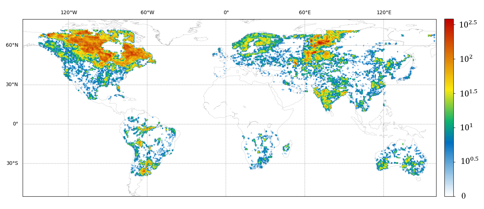
Accurate global glacier mapping is critical for understanding climate change impacts. Despite its importance, automated glacier mapping at a global scale remains largely unexplored. Here we address this gap and propose Glacier-VisionTransformer-U-Net (GlaViTU), a convolutional-transformer deep learning model, and five strategies for multitemporal global-scale glacier mapping using open satellite imagery. Assessing the spatial, temporal and cross-sensor generalisation shows that our best strategy achieves intersection over union >0.85 on previously unobserved images in most cases, which drops to >0.75 for debris-rich areas such as High-Mountain Asia and increases to >0.90 for regions dominated by clean ice. A comparative validation against human expert uncertainties in terms of area and distance deviations underscores GlaViTU performance, approaching or matching expert-level delineation. Adding synthetic aperture radar data, namely, backscatter and interferometric coherence, increases the accuracy in all regions where available. The calibrated confidence for glacier extents is reported making the predictions more reliable and interpretable. We also release a benchmark dataset that covers 9% of glaciers worldwide. Our results support efforts towards automated multitemporal and global glacier mapping.
Read more9/5/2024
🤿
0
Multi-Sensor Deep Learning for Glacier Mapping
Codruc{t}-Andrei Diaconu, Konrad Heidler, Jonathan L. Bamber, Harry Zekollari
The more than 200,000 glaciers outside the ice sheets play a crucial role in our society by influencing sea-level rise, water resource management, natural hazards, biodiversity, and tourism. However, only a fraction of these glaciers benefit from consistent and detailed in-situ observations that allow for assessing their status and changes over time. This limitation can, in part, be overcome by relying on satellite-based Earth Observation techniques. Satellite-based glacier mapping applications have historically mainly relied on manual and semi-automatic detection methods, while recently, a fast and notable transition to deep learning techniques has started. This chapter reviews how combining multi-sensor remote sensing data and deep learning allows us to better delineate (i.e. map) glaciers and detect their temporal changes. We explain how relying on deep learning multi-sensor frameworks to map glaciers benefits from the extensive availability of regional and global glacier inventories. We also analyse the rationale behind glacier mapping, the benefits of deep learning methodologies, and the inherent challenges in integrating multi-sensor earth observation data with deep learning algorithms. While our review aims to provide a broad overview of glacier mapping efforts, we highlight a few setups where deep learning multi-sensor remote sensing applications have a considerable potential added value. This includes applications for debris-covered and rock glaciers that are visually difficult to distinguish from surroundings and for calving glaciers that are in contact with the ocean. These specific cases are illustrated through a series of visual imageries, highlighting some significant advantages and challenges when detecting glacier changes, including dealing with seasonal snow cover, changing debris coverage, and distinguishing glacier fronts from the surrounding sea ice.
Read more9/19/2024
👁️
0
Global-Local Detail Guided Transformer for Sea Ice Recognition in Optical Remote Sensing Images
Zhanchao Huang, Wenjun Hong, Hua Su
The recognition of sea ice is of great significance for reflecting climate change and ensuring the safety of ship navigation. Recently, many deep learning based methods have been proposed and applied to segment and recognize sea ice regions. However, the diverse scales of sea ice areas, the zigzag and fine edge contours, and the difficulty in distinguishing different types of sea ice pose challenges to existing sea ice recognition models. In this paper, a Global-Local Detail Guided Transformer (GDGT) method is proposed for sea ice recognition in optical remote sensing images. In GDGT, a global-local feature fusiont mechanism is designed to fuse global structural correlation features and local spatial detail features. Furthermore, a detail-guided decoder is developed to retain more high-resolution detail information during feature reconstruction for improving the performance of sea ice recognition. Experiments on the produced sea ice dataset demonstrated the effectiveness and advancement of GDGT.
Read more5/24/2024
0
Constructing a High Temporal Resolution Global Lakes Dataset via Swin-Unet with Applications to Area Prediction
Yutian Han, Baoxiang Huang, He Gao
Lakes provide a wide range of valuable ecosystem services, such as water supply, biodiversity habitats, and carbon sequestration. However, lakes are increasingly threatened by climate change and human activities. Therefore, continuous global monitoring of lake dynamics is crucial, but remains challenging on a large scale. The recently developed Global Lakes Area Database (GLAKES) has mapped over 3.4 million lakes worldwide, but it only provides data at decadal intervals, which may be insufficient to capture rapid or short-term changes.This paper introduces an expanded lake database, GLAKES-Additional, which offers biennial delineations and area measurements for 152,567 lakes globally from 1990 to 2021. We employed the Swin-Unet model, replacing traditional convolution operations, to effectively address the challenges posed by the receptive field requirements of high spatial resolution satellite imagery. The increased biennial time resolution helps to quantitatively attribute lake area changes to climatic and hydrological drivers, such as precipitation and temperature changes.For predicting lake area changes, we used a Long Short-Term Memory (LSTM) neural network and an extended time series dataset for preliminary modeling. Under climate and land use scenarios, our model achieved an RMSE of 0.317 km^2 in predicting future lake area changes.
Read more8/21/2024