Markers Identification for Relative Pose Estimation of an Uncooperative Target

0

Sign in to get full access
Overview
- The paper focuses on identifying markers on an uncooperative target object to estimate its relative pose.
- It proposes a method to detect and localize markers on the target's surface using computer vision techniques.
- The estimated relative pose information can be used for tasks like spacecraft rendezvous and docking.
Plain English Explanation
The researchers developed a way to determine the position and orientation of an object that is not cooperating or helping with the process. This is important for things like spacecraft rendezvous and docking, where a spacecraft needs to precisely align itself with another object in space.
The key idea is to identify special markers or visual cues on the surface of the uncooperative target object. By detecting and localizing these markers, the researchers can estimate the relative pose - the position and orientation - of the target object compared to the spacecraft or camera observing it. This relative pose information is crucial for successfully docking or maneuvering around the target.
The paper presents a computer vision-based approach to reliably detect and locate these markers on the target's surface, even when the object is not actively assisting in the process. This allows the spacecraft to autonomously determine the target's pose without requiring specialized sensors or cooperation from the target itself.
Technical Explanation
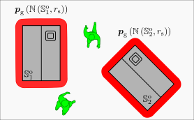
The paper proposes a markers identification method for relative pose estimation of an uncooperative target. The key steps are:
-
Marker Detection: The system uses computer vision techniques to detect the presence of markers on the target's surface in camera images. This involves applying object detection models to localize the markers.
-
Marker Localization: Once detected, the system estimates the 3D position of each marker relative to the camera frame using depth information or other cues. This provides the 3D coordinates of the markers.
-
Pose Estimation: With the 3D marker locations, the system can estimate the full 6-DOF (degree-of-freedom) relative pose between the camera and the target object. This is done by solving an optimization problem that aligns the detected marker positions with a known 3D model of the target.
The paper evaluates this approach using both simulated and real-world data, demonstrating its effectiveness for applications like spacecraft rendezvous and docking. The results show robust marker detection and accurate relative pose estimation, even when the target is uncooperative and its motion is unknown.
Critical Analysis
The paper provides a solid technical contribution to the problem of relative pose estimation for uncooperative targets. However, a few limitations and areas for further research are worth noting:
- The approach relies on the presence of distinct, identifiable markers on the target's surface. In some scenarios, such markers may not be available or easily detected.
- The performance of the system may degrade in challenging conditions, such as poor lighting, occlusions, or significant distance between the camera and target.
- The paper does not explore the robustness of the approach to target maneuvering or changes in the target's configuration over time.
- Further research could investigate combining the marker-based approach with other complementary techniques, such as model-based tracking or learning-based methods, to enhance the overall performance and applicability.
Conclusion
This paper presents a novel approach for identifying markers on an uncooperative target and using this information to estimate the relative pose between the target and the observing camera or spacecraft. The proposed computer vision-based techniques demonstrate promising results for applications like spacecraft rendezvous and docking, where precise relative pose estimation is critical. While the approach has some limitations, it represents an important step forward in tackling the challenges of working with uncooperative targets in space and other domains.
This summary was produced with help from an AI and may contain inaccuracies - check out the links to read the original source documents!
Related Papers
0
Markers Identification for Relative Pose Estimation of an Uncooperative Target
Batu Candan, Simone Servadio
This paper introduces a novel method using chaser spacecraft image processing and Convolutional Neural Networks (CNNs) to detect structural markers on the European Space Agency's (ESA) Environmental Satellite (ENVISAT) for safe de-orbiting. Advanced image pre-processing techniques, including noise addition and blurring, are employed to improve marker detection accuracy and robustness. Initial results show promising potential for autonomous space debris removal, supporting proactive strategies for space sustainability. The effectiveness of our approach suggests that our estimation method could significantly enhance the safety and efficiency of debris removal operations by implementing more robust and autonomous systems in actual space missions.
Read more7/31/2024

0
Vision-Based Detection of Uncooperative Targets and Components on Small Satellites
Hannah Grauer, Elena-Sorina Lupu, Connor Lee, Soon-Jo Chung, Darren Rowen, Benjamen Bycroft, Phaedrus Leeds, John Brader
Space debris and inactive satellites pose a threat to the safety and integrity of operational spacecraft and motivate the need for space situational awareness techniques. These uncooperative targets create a challenging tracking and detection problem due to a lack of prior knowledge of their features, trajectories, or even existence. Recent advancements in computer vision models can be used to improve upon existing methods for tracking such uncooperative targets to make them more robust and reliable to the wide-ranging nature of the target. This paper introduces an autonomous detection model designed to identify and monitor these objects using learning and computer vision. The autonomous detection method aims to identify and accurately track the uncooperative targets in varied circumstances, including different camera spectral sensitivities, lighting, and backgrounds. Our method adapts to the relative distance between the observing spacecraft and the target, and different detection strategies are adjusted based on distance. At larger distances, we utilize You Only Look Once (YOLOv8), a multitask Convolutional Neural Network (CNN), for zero-shot and domain-specific single-shot real time detection of the target. At shorter distances, we use knowledge distillation to combine visual foundation models with a lightweight fast segmentation CNN (Fast-SCNN) to segment the spacecraft components with low storage requirements and fast inference times, and to enable weight updates from earth and possible onboard training. Lastly, we test our method on a custom dataset simulating the unique conditions encountered in space, as well as a publicly-available dataset.
Read more8/23/2024

0
YoloTag: Vision-based Robust UAV Navigation with Fiducial Markers
Sourav Raxit, Simant Bahadur Singh, Abdullah Al Redwan Newaz
By harnessing fiducial markers as visual landmarks in the environment, Unmanned Aerial Vehicles (UAVs) can rapidly build precise maps and navigate spaces safely and efficiently, unlocking their potential for fluent collaboration and coexistence with humans. Existing fiducial marker methods rely on handcrafted feature extraction, which sacrifices accuracy. On the other hand, deep learning pipelines for marker detection fail to meet real-time runtime constraints crucial for navigation applications. In this work, we propose YoloTag textemdash a real-time fiducial marker-based localization system. YoloTag uses a lightweight YOLO v8 object detector to accurately detect fiducial markers in images while meeting the runtime constraints needed for navigation. The detected markers are then used by an efficient perspective-n-point algorithm to estimate UAV states. However, this localization system introduces noise, causing instability in trajectory tracking. To suppress noise, we design a higher-order Butterworth filter that effectively eliminates noise through frequency domain analysis. We evaluate our algorithm through real-robot experiments in an indoor environment, comparing the trajectory tracking performance of our method against other approaches in terms of several distance metrics.
Read more9/5/2024
0
Set-membership target search and tracking within an unknown cluttered area using cooperating UAVs equipped with vision systems
Maxime Zagar, Luc Meyer, Michel Kieffer, H'el`eene Piet-Lahanier
This paper addresses the problem of target search and tracking using a fleet of cooperating UAVs evolving in some unknown region of interest containing an a priori unknown number of moving ground targets. Each drone is equipped with an embedded Computer Vision System (CVS), providing an image with labeled pixels and a depth map of the observed part of its environment. Moreover, a box containing the corresponding pixels in the image frame is available when a UAV identifies a target. Hypotheses regarding information provided by the pixel classification, depth map construction, and target identification algorithms are proposed to allow its exploitation by set-membership approaches. A set-membership target location estimator is developed using the information provided by the CVS. Each UAV evaluates sets guaranteed to contain the location of the identified targets and a set possibly containing the locations of targets still to be identified. Then, each UAV uses these sets to search and track targets cooperatively.
Read more7/16/2024