Robust Vehicle Localization and Tracking in Rain using Street Maps

0
Sign in to get full access
Overview
- This paper presents a robust vehicle localization and tracking system for driving in rainy conditions using street maps.
- The system combines visual odometry, camera-based semantic segmentation, and map matching to accurately localize and track the vehicle's position on a street map.
- The authors demonstrate the effectiveness of their approach on a challenging dataset of driving in heavy rain.
Plain English Explanation
The research paper describes a system that can accurately locate and track a vehicle's position on a digital map, even in rainy weather. This is an important problem for self-driving cars, as heavy rain can make it difficult for the vehicle's cameras and sensors to reliably determine its location.
The key idea is to combine several different techniques to get a more complete picture of the vehicle's surroundings and position. First, the system uses "visual odometry" to estimate the vehicle's motion by analyzing the changes in sequential camera images. Second, it uses computer vision to identify semantic elements in the camera images, like roads, buildings, and other landmarks. Finally, it matches these visual cues to a digital street map to precisely locate the vehicle's position.
By integrating these different sources of information, the system is able to overcome the limitations of any single approach and maintain accurate localization even in rainy conditions that would confuse a traditional GPS-based system. This could be a key technology for enabling self-driving cars to reliably navigate in all weather conditions.
Technical Explanation
The paper presents a multi-modal approach for robust vehicle localization and tracking in rain using street maps. The core components of the system are:
-
Visual Odometry: The system uses a camera-based visual odometry algorithm to estimate the vehicle's motion and update its position on the map over time. This helps overcome the limitations of GPS in rainy conditions.
-
Semantic Segmentation: A deep neural network is used to perform semantic segmentation of the camera images, identifying elements like roads, buildings, and other landmarks. This semantic information is then matched against the map to refine the vehicle's localization.
-
Map Matching: The system combines the visual odometry and semantic segmentation outputs to find the best matching location on a digital street map. This map matching process improves localization accuracy and robustness.
The authors evaluate their approach on a challenging dataset of driving in heavy rain, and demonstrate significant improvements in localization accuracy compared to using visual odometry or GPS alone. The system shows promise for enabling robust autonomous vehicle navigation in adverse weather conditions.
Critical Analysis
The paper presents a well-designed and comprehensive approach to the problem of vehicle localization in rain, drawing on multiple complementary techniques. The authors have done a thorough job of evaluating their system's performance on a realistic dataset.
One potential limitation is that the system still relies on access to a detailed digital street map, which may not always be available, especially in less developed regions. An interesting area for further research would be to explore how the system could be adapted to work with more limited or even crowdsourced mapping data.
Additionally, the paper does not provide much insight into the computational requirements or latency of the system, which would be important considerations for real-world deployment in self-driving cars. Further exploration of the system's efficiency and scalability would be valuable.
Overall, this is a promising piece of research that demonstrates the value of combining different sensing and localization approaches to achieve robust performance in challenging conditions. The techniques presented could have significant implications for the development of reliable autonomous driving systems.
Conclusion
This paper presents a novel approach for robust vehicle localization and tracking in rainy conditions using a combination of visual odometry, semantic segmentation, and map matching. The authors show that their multi-modal system can maintain accurate localization where traditional GPS-based approaches fail, paving the way for more reliable autonomous driving in adverse weather.
While the system still has some limitations, such as its reliance on detailed digital maps, the core ideas and techniques demonstrated in this research represent an important step forward in enabling self-driving cars to navigate safely and effectively in the real world.
This summary was produced with help from an AI and may contain inaccuracies - check out the links to read the original source documents!
Related Papers
0
Robust Vehicle Localization and Tracking in Rain using Street Maps
Yu Xiang Tan, Malika Meghjani
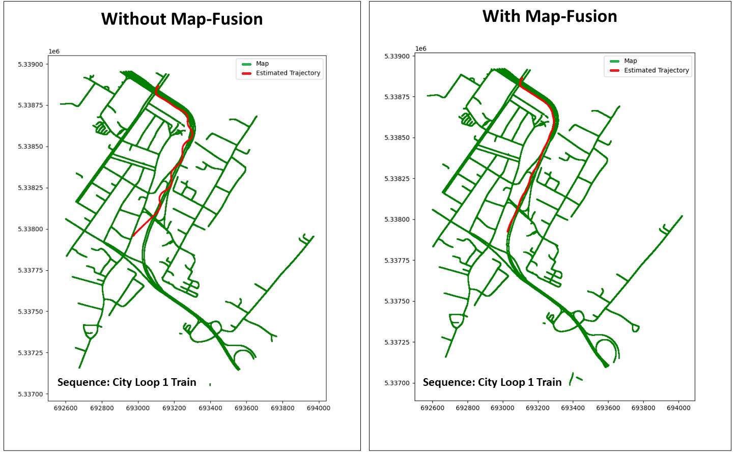
GPS-based vehicle localization and tracking suffers from unstable positional information commonly experienced in tunnel segments and in dense urban areas. Also, both Visual Odometry (VO) and Visual Inertial Odometry (VIO) are susceptible to adverse weather conditions that causes occlusions or blur on the visual input. In this paper, we propose a novel approach for vehicle localization that uses street network based map information to correct drifting odometry estimates and intermittent GPS measurements especially, in adversarial scenarios such as driving in rain and tunnels. Specifically, our approach is a flexible fusion algorithm that integrates intermittent GPS, drifting IMU and VO estimates together with 2D map information for robust vehicle localization and tracking. We refer to our approach as Map-Fusion. We robustly evaluate our proposed approach on four geographically diverse datasets from different countries ranging across clear and rain weather conditions. These datasets also include challenging visual segments in tunnels and underpasses. We show that with the integration of the map information, our Map-Fusion algorithm reduces the error of the state-of-the-art VO and VIO approaches across all datasets. We also validate our proposed algorithm in a real-world environment and in real-time on a hardware constrained mobile robot. Map-Fusion achieved 2.46m error in clear weather and 6.05m error in rain weather for a 150m route.
Read more9/4/2024
🧪
0
Evaluating Visual Odometry Methods for Autonomous Driving in Rain
Yu Xiang Tan, Marcel Bartholomeus Prasetyo, Mohammad Alif Daffa, Deshpande Sunny Nitin, Malika Meghjani
The increasing demand for autonomous vehicles has created a need for robust navigation systems that can also operate effectively in adverse weather conditions. Visual odometry is a technique used in these navigation systems, enabling the estimation of vehicle position and motion using input from onboard cameras. However, visual odometry accuracy can be significantly impacted in challenging weather conditions, such as heavy rain, snow, or fog. In this paper, we evaluate a range of visual odometry methods, including our DROID-SLAM based heuristic approach. Specifically, these algorithms are tested on both clear and rainy weather urban driving data to evaluate their robustness. We compiled a dataset comprising of a range of rainy weather conditions from different cities. This includes, the Oxford Robotcar dataset from Oxford, the 4Seasons dataset from Munich and an internal dataset collected in Singapore. We evaluated different visual odometry algorithms for both monocular and stereo camera setups using the Absolute Trajectory Error (ATE). From the range of approaches evaluated, our findings suggest that the Depth and Flow for Visual Odometry (DF-VO) algorithm with monocular setup performed the best for short range distances (< 500m) and our proposed DROID-SLAM based heuristic approach for the stereo setup performed relatively well for long-term localization. Both VO algorithms suggested a need for a more robust sensor fusion based approach for localization in rain.
Read more5/6/2024

0
Is That Rain? Understanding Effects on Visual Odometry Performance for Autonomous UAVs and Efficient DNN-based Rain Classification at the Edge
Andrea Albanese, Yanran Wang, Davide Brunelli, David Boyle
The development of safe and reliable autonomous unmanned aerial vehicles relies on the ability of the system to recognise and adapt to changes in the local environment based on sensor inputs. State-of-the-art local tracking and trajectory planning are typically performed using camera sensor input to the flight control algorithm, but the extent to which environmental disturbances like rain affect the performance of these systems is largely unknown. In this paper, we first describe the development of an open dataset comprising ~335k images to examine these effects for seven different classes of precipitation conditions and show that a worst-case average tracking error of 1.5 m is possible for a state-of-the-art visual odometry system (VINS-Fusion). We then use the dataset to train a set of deep neural network models suited to mobile and constrained deployment scenarios to determine the extent to which it may be possible to efficiently and accurately classify these `rainy' conditions. The most lightweight of these models (MobileNetV3 small) can achieve an accuracy of 90% with a memory footprint of just 1.28 MB and a frame rate of 93 FPS, which is suitable for deployment in resource-constrained and latency-sensitive systems. We demonstrate a classification latency in the order of milliseconds using typical flight computer hardware. Accordingly, such a model can feed into the disturbance estimation component of an autonomous flight controller. In addition, data from unmanned aerial vehicles with the ability to accurately determine environmental conditions in real time may contribute to developing more granular timely localised weather forecasting.
Read more7/18/2024

0
Online Temporal Fusion for Vectorized Map Construction in Mapless Autonomous Driving
Jiagang Chen, Liangliang Pan, Shunping Ji, Ji Zhao, Zichao Zhang
To reduce the reliance on high-definition (HD) maps, a growing trend in autonomous driving is leveraging on-board sensors to generate vectorized maps online. However, current methods are mostly constrained by processing only single-frame inputs, which hampers their robustness and effectiveness in complex scenarios. To overcome this problem, we propose an online map construction system that exploits the long-term temporal information to build a consistent vectorized map. First, the system efficiently fuses all historical road marking detections from an off-the-shelf network into a semantic voxel map, which is implemented using a hashing-based strategy to exploit the sparsity of road elements. Then reliable voxels are found by examining the fused information and incrementally clustered into an instance-level representation of road markings. Finally, the system incorporates domain knowledge to estimate the geometric and topological structures of roads, which can be directly consumed by the planning and control (PnC) module. Through experiments conducted in complicated urban environments, we have demonstrated that the output of our system is more consistent and accurate than the network output by a large margin and can be effectively used in a closed-loop autonomous driving system.
Read more9/4/2024