Detection Is Tracking: Point Cloud Multi-Sweep Deep Learning Models Revisited
2402.15756
0
0

Abstract
Conventional tracking paradigm takes in instantaneous measurements such as range and bearing, and produces object tracks across time. In applications such as autonomous driving, lidar measurements in the form of point clouds are usually passed through a virtual sensor realized by a deep learning model, to produce measurements such as bounding boxes, which are in turn ingested by a tracking module to produce object tracks. Very often multiple lidar sweeps are accumulated in a buffer to merge and become the input to the virtual sensor. We argue in this paper that such an input already contains temporal information, and therefore the virtual sensor output should also contain temporal information, not just instantaneous values for the time corresponding to the end of the buffer. In particular, we present the deep learning model called MULti-Sweep PAired Detector (MULSPAD) that produces, for each detected object, a pair of bounding boxes at both the end time and the beginning time of the input buffer. This is achieved with fairly straightforward changes in commonly used lidar detection models, and with only marginal extra processing, but the resulting symmetry is satisfying. Such paired detections make it possible not only to construct rudimentary trackers fairly easily, but also to construct more sophisticated trackers that can exploit the extra information conveyed by the pair and be robust to choices of motion models and object birth/death models. We have conducted preliminary training and experimentation using Waymo Open Dataset, which shows the efficacy of our proposed method.
Create account to get full access
Overview
- This paper explores the intersection of object detection and multi-object tracking in the context of point cloud data from LiDAR sensors, commonly used in autonomous driving applications.
- The researchers revisit and build upon existing multi-sweep deep learning models, which leverage the temporal information in a sequence of point cloud frames to improve detection and tracking performance.
- The paper presents a comprehensive study, evaluating different model architectures and training strategies to understand the strengths and limitations of this approach.
Plain English Explanation
Self-driving cars and other autonomous systems rely heavily on sensors like LiDAR, which use laser beams to create a detailed 3D map of the surrounding environment. Analyzing this "point cloud" data is crucial for tasks like detecting and tracking objects, such as other vehicles, pedestrians, and obstacles.
The researchers in this paper wanted to explore how the temporal information in a sequence of point cloud frames (i.e., multiple "sweeps" of the LiDAR sensor) could be used to improve the performance of object detection and tracking models. They re-examined existing deep learning approaches that leverage this multi-sweep data, testing different model architectures and training strategies to understand the strengths and limitations of this approach.
By taking a closer look at the intersection of detection and tracking, the researchers hope to advance the state-of-the-art in autonomous perception systems, which is a critical component for the safe and reliable operation of self-driving cars and other autonomous vehicles.
Technical Explanation
The paper builds upon previous work on multi-sweep deep learning models for point cloud analysis, which aim to exploit the temporal information in a sequence of point cloud frames to improve detection and tracking performance. The researchers evaluate different model architectures and training strategies to understand the trade-offs and limitations of this approach.
One key aspect of the work is the exploration of "detection is tracking" paradigms, where the detection and tracking tasks are closely coupled. This is in contrast to traditional approaches that treat detection and tracking as separate, sequential steps. The researchers investigate methods that learn to jointly detect and track objects, as well as those that use tracking information to refine the object detections.
The paper also examines the use of optical flow and scene flow techniques to capture the motion information in the point cloud data, and how this can be incorporated into the multi-sweep deep learning models.
Additionally, the researchers explore the potential benefits of multi-modal sensor fusion, combining LiDAR point clouds with other data sources, such as radar or camera images, to further enhance the detection and tracking capabilities.
Critical Analysis
The paper provides a comprehensive evaluation of the strengths and limitations of multi-sweep deep learning models for point cloud analysis, highlighting the trade-offs between detection accuracy, tracking performance, and computational efficiency.
One potential limitation mentioned in the paper is the sensitivity of these models to changes in the sensor configuration or environmental conditions, which can impact their generalization ability. The researchers suggest that further investigation is needed to understand the robustness of these approaches across a wider range of scenarios.
Additionally, the paper acknowledges the potential challenges in effectively fusing multi-modal sensor data, as the different data sources may have varying levels of noise, resolution, and coverage. Developing robust and efficient fusion strategies remains an active area of research.
Another area for further exploration is the incorporation of higher-level reasoning and contextual information into the detection and tracking models, which could help resolve ambiguities and improve the overall performance in complex scenes.
Overall, this paper provides valuable insights into the current state of multi-sweep deep learning models for point cloud analysis, highlighting both the progress made and the remaining challenges in this important field of autonomous perception.
Conclusion
This paper presents a comprehensive study of multi-sweep deep learning models for point cloud analysis, focused on the intersection of object detection and multi-object tracking. The researchers explore various model architectures and training strategies, shedding light on the strengths and limitations of this approach.
By revisiting and building upon existing work, the paper advances the state-of-the-art in autonomous perception, a critical component for the safe and reliable operation of self-driving cars and other autonomous systems. The insights gained from this research can inform the development of more robust and efficient detection and tracking algorithms, ultimately contributing to the progress of autonomous driving and related applications.
This summary was produced with help from an AI and may contain inaccuracies - check out the links to read the original source documents!
Related Papers
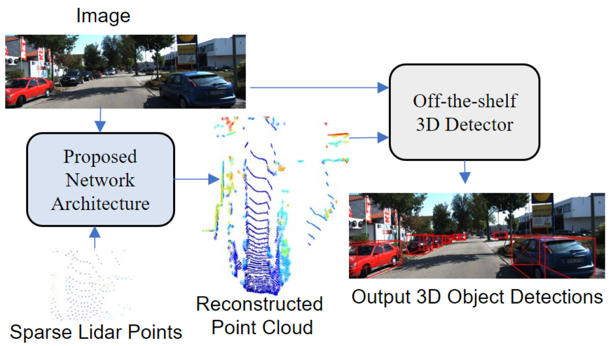
Sparse Points to Dense Clouds: Enhancing 3D Detection with Limited LiDAR Data
Aakash Kumar, Chen Chen, Ajmal Mian, Neils Lobo, Mubarak Shah
0
0
3D detection is a critical task that enables machines to identify and locate objects in three-dimensional space. It has a broad range of applications in several fields, including autonomous driving, robotics and augmented reality. Monocular 3D detection is attractive as it requires only a single camera, however, it lacks the accuracy and robustness required for real world applications. High resolution LiDAR on the other hand, can be expensive and lead to interference problems in heavy traffic given their active transmissions. We propose a balanced approach that combines the advantages of monocular and point cloud-based 3D detection. Our method requires only a small number of 3D points, that can be obtained from a low-cost, low-resolution sensor. Specifically, we use only 512 points, which is just 1% of a full LiDAR frame in the KITTI dataset. Our method reconstructs a complete 3D point cloud from this limited 3D information combined with a single image. The reconstructed 3D point cloud and corresponding image can be used by any multi-modal off-the-shelf detector for 3D object detection. By using the proposed network architecture with an off-the-shelf multi-modal 3D detector, the accuracy of 3D detection improves by 20% compared to the state-of-the-art monocular detection methods and 6% to 9% compare to the baseline multi-modal methods on KITTI and JackRabbot datasets.
4/11/2024

Generative AI Empowered LiDAR Point Cloud Generation with Multimodal Transformer
Mohammad Farzanullah, Han Zhang, Akram Bin Sediq, Ali Afana, Melike Erol-Kantarci
0
0
Integrated sensing and communications is a key enabler for the 6G wireless communication systems. The multiple sensing modalities will allow the base station to have a more accurate representation of the environment, leading to context-aware communications. Some widely equipped sensors such as cameras and RADAR sensors can provide some environmental perceptions. However, they are not enough to generate precise environmental representations, especially in adverse weather conditions. On the other hand, the LiDAR sensors provide more accurate representations, however, their widespread adoption is hindered by their high cost. This paper proposes a novel approach to enhance the wireless communication systems by synthesizing LiDAR point clouds from images and RADAR data. Specifically, it uses a multimodal transformer architecture and pre-trained encoding models to enable an accurate LiDAR generation. The proposed framework is evaluated on the DeepSense 6G dataset, which is a real-world dataset curated for context-aware wireless applications. Our results demonstrate the efficacy of the proposed approach in accurately generating LiDAR point clouds. We achieve a modified mean squared error of 10.3931. Visual examination of the images indicates that our model can successfully capture the majority of structures present in the LiDAR point cloud for diverse environments. This will enable the base stations to achieve more precise environmental sensing. By integrating LiDAR synthesis with existing sensing modalities, our method can enhance the performance of various wireless applications, including beam and blockage prediction.
6/28/2024
🔎
Timely Fusion of Surround Radar/Lidar for Object Detection in Autonomous Driving Systems
Wenjing Xie, Tao Hu, Neiwen Ling, Guoliang Xing, Chun Jason Xue, Nan Guan
0
0
Fusing Radar and Lidar sensor data can fully utilize their complementary advantages and provide more accurate reconstruction of the surrounding for autonomous driving systems. Surround Radar/Lidar can provide 360-degree view sampling with the minimal cost, which are promising sensing hardware solutions for autonomous driving systems. However, due to the intrinsic physical constraints, the rotating speed of surround Radar, and thus the frequency to generate Radar data frames, is much lower than surround Lidar. Existing Radar/Lidar fusion methods have to work at the low frequency of surround Radar, which cannot meet the high responsiveness requirement of autonomous driving systems.This paper develops techniques to fuse surround Radar/Lidar with working frequency only limited by the faster surround Lidar instead of the slower surround Radar, based on the state-of-the-art object detection model MVDNet. The basic idea of our approach is simple: we let MVDNet work with temporally unaligned data from Radar/Lidar, so that fusion can take place at any time when a new Lidar data frame arrives, instead of waiting for the slow Radar data frame. However, directly applying MVDNet to temporally unaligned Radar/Lidar data greatly degrades its object detection accuracy. The key information revealed in this paper is that we can achieve high output frequency with little accuracy loss by enhancing the training procedure to explore the temporal redundancy in MVDNet so that it can tolerate the temporal unalignment of input data. We explore several different ways of training enhancement and compare them quantitatively with experiments.
5/28/2024

A Deep Automotive Radar Detector using the RaDelft Dataset
Ignacio Roldan, Andras Palffy, Julian F. P. Kooij, Dariu M. Gavrila, Francesco Fioranelli, Alexander Yarovoy
0
0
The detection of multiple extended targets in complex environments using high-resolution automotive radar is considered. A data-driven approach is proposed where unlabeled synchronized lidar data is used as ground truth to train a neural network with only radar data as input. To this end, the novel, large-scale, real-life, and multi-sensor RaDelft dataset has been recorded using a demonstrator vehicle in different locations in the city of Delft. The dataset, as well as the documentation and example code, is publicly available for those researchers in the field of automotive radar or machine perception. The proposed data-driven detector is able to generate lidar-like point clouds using only radar data from a high-resolution system, which preserves the shape and size of extended targets. The results are compared against conventional CFAR detectors as well as variations of the method to emulate the available approaches in the literature, using the probability of detection, the probability of false alarm, and the Chamfer distance as performance metrics. Moreover, an ablation study was carried out to assess the impact of Doppler and temporal information on detection performance. The proposed method outperforms the different baselines in terms of Chamfer distance, achieving a reduction of 75% against conventional CFAR detectors and 10% against the modified state-of-the-art deep learning-based approaches.
6/28/2024