Geode: A Zero-shot Geospatial Question-Answering Agent with Explicit Reasoning and Precise Spatio-Temporal Retrieval

0

Sign in to get full access
Overview
- The paper "Geode: A Zero-shot Geospatial Question-Answering Agent with Explicit Reasoning and Precise Spatio-Temporal Retrieval" presents a novel AI agent called Geode that can answer geospatial questions without requiring any task-specific training.
- Geode combines large language models with specialized modules for spatial reasoning and information retrieval to provide accurate and explainable answers to a wide range of geospatial queries.
- The key innovations include the use of structured knowledge graphs and spatio-temporal retrieval techniques to enable precise and interpretable question answering.
Plain English Explanation
Geode is an AI system that can answer questions about locations, geography, and spatial relationships without any prior training on specific tasks. Rather than just returning a simple answer, Geode provides an explicit explanation of its reasoning process.
At the core of Geode is a large language model that has been trained on a vast amount of text data. This gives Geode a broad understanding of language and general knowledge. However, to answer geospatial questions, Geode also incorporates specialized modules that can reason about spatial concepts and quickly retrieve relevant information from a structured knowledge base.
For example, if you asked Geode "What is the capital of France?", it would first identify the key entities in the question (France, capital). It would then use its spatial reasoning capabilities to determine that the capital of a country is usually a major city within that country. Geode would then search its knowledge base to find the city designated as the capital of France and return that information, along with an explanation of its thought process.
The researchers behind Geode argue that this approach of blending powerful language understanding with targeted spatial reasoning and retrieval is more effective than simply relying on a generic language model. By making the reasoning explicit, Geode can provide answers that are more accurate, interpretable, and trustworthy than a "black box" AI system.
Technical Explanation
The Geode system leverages a combination of large language models and specialized modules to enable zero-shot geospatial question answering. At the core of Geode is a pre-trained language model, such as GPT-3, which provides a broad understanding of language and knowledge. However, to effectively answer geospatial queries, Geode incorporates additional components:
-
Spatial Reasoning Module: This module is responsible for interpreting the spatial concepts and relationships expressed in the question, such as identifying the key entities (e.g. countries, cities, locations) and understanding their spatial properties and connections.
-
Spatio-Temporal Retrieval Module: Geode maintains a structured knowledge graph containing geospatial information, such as geographical boundaries, administrative hierarchies, and historical events. The retrieval module can quickly locate and extract the most relevant facts from this knowledge base to answer the given question.
-
Explanation Generation Module: Rather than just returning a final answer, Geode provides a step-by-step explanation of its reasoning process. This includes detailing how it interpreted the question, the key inferences it made, and the specific evidence it found to support the answer.
The researchers evaluated Geode on a variety of geospatial question-answering benchmarks, including GemQuAD and datasets focused on evaluating the spatial understanding capabilities of large language models. Geode demonstrated strong performance, outperforming previous state-of-the-art models, while also providing more interpretable and trustworthy outputs.
Critical Analysis
The Geode system represents an important step forward in developing AI agents that can engage in geospatial reasoning and question answering. By explicitly incorporating spatial reasoning and retrieval components, the researchers have addressed some of the limitations of relying solely on large language models for such tasks.
However, the paper also acknowledges several caveats and areas for further research. For example, the current knowledge graph used by Geode is relatively limited in scope, focusing primarily on geographic and administrative data. Expanding the knowledge base to include a wider range of spatio-temporal information, such as geospatial data from remote sensing platforms or geospatial data from the Common Crawl corpus, could further enhance Geode's capabilities.
Additionally, while the researchers demonstrate Geode's effectiveness on existing benchmarks, it remains to be seen how well the system would perform on more open-ended, real-world geospatial queries that may involve complex reasoning or require combining information from multiple sources. Continued research and evaluation in this direction would help assess the broader applicability of the Geode approach.
Conclusion
The Geode system represents a significant advance in the field of geospatial question answering, demonstrating how the integration of large language models with specialized spatial reasoning and retrieval components can enable accurate and interpretable AI agents. By providing explicit explanations for its outputs, Geode offers a more transparent and trustworthy approach to geospatial information processing compared to traditional "black box" AI systems.
As the researchers continue to expand the knowledge and capabilities of the Geode agent, it has the potential to become a valuable tool for a wide range of applications, from educational and recreational uses to more specialized domains such as urban planning, environmental monitoring, and disaster response. The continued development of such spatially-aware AI systems will be crucial for unlocking the full potential of large language models in understanding and reasoning about the physical world.
This summary was produced with help from an AI and may contain inaccuracies - check out the links to read the original source documents!
Related Papers
0
Geode: A Zero-shot Geospatial Question-Answering Agent with Explicit Reasoning and Precise Spatio-Temporal Retrieval
Devashish Vikas Gupta, Azeez Syed Ali Ishaqui, Divya Kiran Kadiyala
Large language models (LLMs) have shown promising results in learning and contextualizing information from different forms of data. Recent advancements in foundational models, particularly those employing self-attention mechanisms, have significantly enhanced our ability to comprehend the semantics of diverse data types. One such area that could highly benefit from multi-modality is in understanding geospatial data, which inherently has multiple modalities. However, current Natural Language Processing (NLP) mechanisms struggle to effectively address geospatial queries. Existing pre-trained LLMs are inadequately equipped to meet the unique demands of geospatial data, lacking the ability to retrieve precise spatio-temporal data in real-time, thus leading to significantly reduced accuracy in answering complex geospatial queries. To address these limitations, we introduce Geode--a pioneering system designed to tackle zero-shot geospatial question-answering tasks with high precision using spatio-temporal data retrieval. Our approach represents a significant improvement in addressing the limitations of current LLM models, demonstrating remarkable improvement in geospatial question-answering abilities compared to existing state-of-the-art pre-trained models.
Read more7/17/2024
0
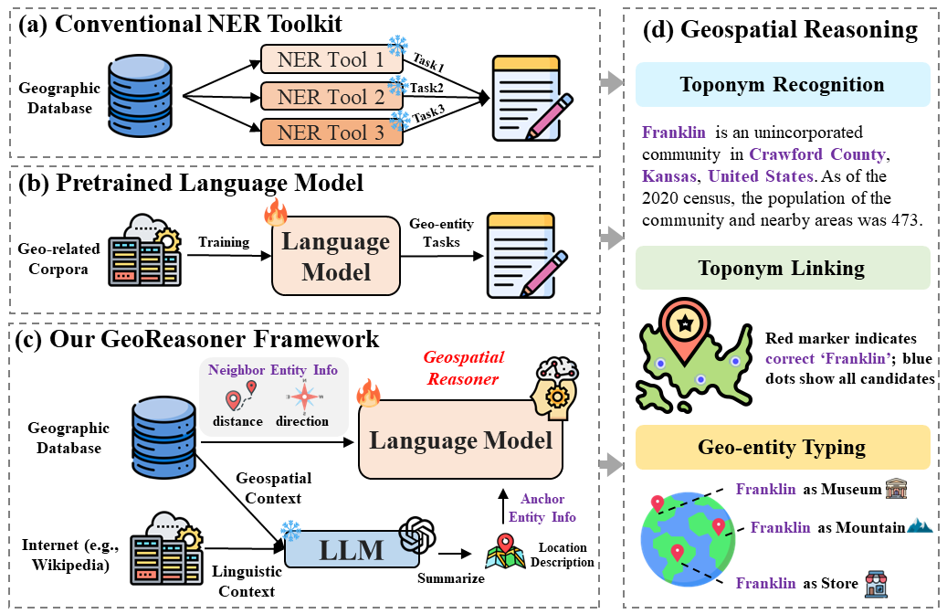
GeoReasoner: Reasoning On Geospatially Grounded Context For Natural Language Understanding
Yibo Yan, Joey Lee
In human reading and communication, individuals tend to engage in geospatial reasoning, which involves recognizing geographic entities and making informed inferences about their interrelationships. To mimic such cognitive process, current methods either utilize conventional natural language understanding toolkits, or directly apply models pretrained on geo-related natural language corpora. However, these methods face two significant challenges: i) they do not generalize well to unseen geospatial scenarios, and ii) they overlook the importance of integrating geospatial context from geographical databases with linguistic information from the Internet. To handle these challenges, we propose GeoReasoner, a language model capable of reasoning on geospatially grounded natural language. Specifically, it first leverages Large Language Models (LLMs) to generate a comprehensive location description based on linguistic and geospatial information. It also encodes direction and distance information into spatial embedding via treating them as pseudo-sentences. Consequently, the model is trained on both anchor-level and neighbor-level inputs to learn geo-entity representation. Extensive experimental results demonstrate GeoReasoner's superiority in three tasks: toponym recognition, toponym linking, and geo-entity typing, compared to the state-of-the-art baselines.
Read more8/22/2024

0
Geolocation Representation from Large Language Models are Generic Enhancers for Spatio-Temporal Learning
Junlin He, Tong Nie, Wei Ma
In the geospatial domain, universal representation models are significantly less prevalent than their extensive use in natural language processing and computer vision. This discrepancy arises primarily from the high costs associated with the input of existing representation models, which often require street views and mobility data. To address this, we develop a novel, training-free method that leverages large language models (LLMs) and auxiliary map data from OpenStreetMap to derive geolocation representations (LLMGeovec). LLMGeovec can represent the geographic semantics of city, country, and global scales, which acts as a generic enhancer for spatio-temporal learning. Specifically, by direct feature concatenation, we introduce a simple yet effective paradigm for enhancing multiple spatio-temporal tasks including geographic prediction (GP), long-term time series forecasting (LTSF), and graph-based spatio-temporal forecasting (GSTF). LLMGeovec can seamlessly integrate into a wide spectrum of spatio-temporal learning models, providing immediate enhancements. Experimental results demonstrate that LLMGeovec achieves global coverage and significantly boosts the performance of leading GP, LTSF, and GSTF models.
Read more8/23/2024
🎯
0
Evaluating Tool-Augmented Agents in Remote Sensing Platforms
Simranjit Singh, Michael Fore, Dimitrios Stamoulis
Tool-augmented Large Language Models (LLMs) have shown impressive capabilities in remote sensing (RS) applications. However, existing benchmarks assume question-answering input templates over predefined image-text data pairs. These standalone instructions neglect the intricacies of realistic user-grounded tasks. Consider a geospatial analyst: they zoom in a map area, they draw a region over which to collect satellite imagery, and they succinctly ask Detect all objects here. Where is `here`, if it is not explicitly hardcoded in the image-text template, but instead is implied by the system state, e.g., the live map positioning? To bridge this gap, we present GeoLLM-QA, a benchmark designed to capture long sequences of verbal, visual, and click-based actions on a real UI platform. Through in-depth evaluation of state-of-the-art LLMs over a diverse set of 1,000 tasks, we offer insights towards stronger agents for RS applications.
Read more5/3/2024