GRID-FAST: A Grid-based Intersection Detection for Fast Semantic Topometric Mapping

0

Sign in to get full access
Overview
- The paper presents GRID-FAST, a grid-based approach for fast and accurate semantic topometric mapping.
- The method uses a grid-based intersection detection algorithm to efficiently identify intersections in 2D laser scans, which are then used to build a semantic topometric map.
- The authors demonstrate that GRID-FAST achieves state-of-the-art performance on several benchmark datasets while being significantly faster than existing methods.
Plain English Explanation
GRID-FAST is a new way to create detailed maps of an environment using laser scans. The key idea is to divide the environment into a grid and then quickly identify where the laser beams intersect with the grid. These intersection points are then used to build a map that not only shows the layout of the environment, but also labels different objects and features, like walls, doors, and furniture.
Compared to other mapping methods, GRID-FAST is much faster, which is important for real-time applications like robot navigation or self-driving cars. The authors show that GRID-FAST can create these detailed maps more quickly and accurately than previous approaches.
The speed and accuracy of GRID-FAST could make it useful for a wide range of applications that require detailed, up-to-date maps of an environment, such as RoboHop, G-Loc, or QuestMaps. It could also be combined with other techniques like GroundGridLidar to create even more comprehensive maps.
Technical Explanation
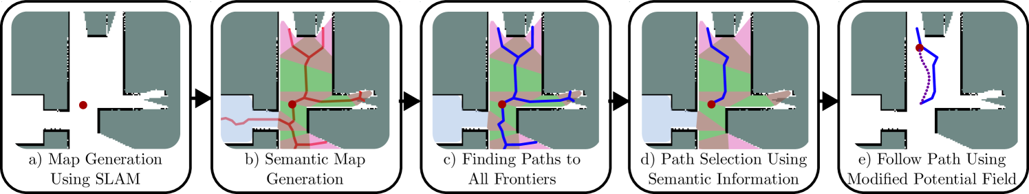
The core of GRID-FAST is a grid-based intersection detection algorithm that efficiently identifies intersections between 2D laser scans and a grid representation of the environment. The authors first discretize the environment into a grid, then for each laser scan, they determine which grid cells the beam passes through. By tracking these intersections, they can efficiently identify key points in the environment, like corners and doorways.
These intersection points are then used to construct a semantic topometric map, which represents the environment's layout and also labels different objects and features. This is done by associating semantic information (e.g., wall, door, furniture) with the intersection points based on the local laser scan geometry.
The authors demonstrate that GRID-FAST outperforms state-of-the-art methods like FAST-LGS on several benchmark datasets, achieving higher accuracy while being significantly faster. This speed advantage makes GRID-FAST well-suited for real-time applications that require frequent map updates.
Critical Analysis
The authors present a thorough evaluation of GRID-FAST, demonstrating its superior performance on several datasets. However, the paper does not discuss potential limitations or edge cases where the method may struggle. For example, the grid-based approach may not handle highly unstructured or dynamic environments as well as other methods.
Additionally, the paper does not compare GRID-FAST to other semantic mapping techniques beyond the FAST-LGS baseline. It would be valuable to see how it performs relative to other state-of-the-art approaches, such as those that leverage deep learning or other advanced techniques.
Overall, the GRID-FAST method appears to be a promising advance in semantic topometric mapping, but further research is needed to fully understand its strengths, weaknesses, and potential applications.
Conclusion
The GRID-FAST method presented in this paper offers a fast and accurate approach to semantic topometric mapping using 2D laser scans. By efficiently identifying intersections in a grid-based representation of the environment, GRID-FAST can construct detailed maps that label different objects and features, such as walls, doors, and furniture.
The speed and accuracy of GRID-FAST make it a potentially valuable tool for a wide range of applications that require frequent updates to detailed maps, such as robot navigation, self-driving cars, and augmented reality. While the paper does not address all potential limitations, the authors have demonstrated a significant advancement in the field of semantic mapping that warrants further exploration and development.
This summary was produced with help from an AI and may contain inaccuracies - check out the links to read the original source documents!
Related Papers
0
GRID-FAST: A Grid-based Intersection Detection for Fast Semantic Topometric Mapping
Scott Fredriksson, Akshit Saradagi, George Nikolakopoulos
This article introduces a novel approach to constructing a topometric map that allows for efficient navigation and decision-making in mobile robotics applications. The method generates the topometric map from a 2D grid-based map. The topometric map segments areas of the input map into different structural-semantic classes: intersections, pathways, dead ends, and pathways leading to unexplored areas. This method is grounded in a new technique for intersection detection that identifies the area and the openings of intersections in a semantically meaningful way. The framework introduces two levels of pre-filtering with minimal computational cost to eliminate small openings and objects from the map which are unimportant in the context of high-level map segmentation and decision making. The topological map generated by GRID-FAST enables fast navigation in large-scale environments, and the structural semantics can aid in mission planning, autonomous exploration, and human-to-robot cooperation. The efficacy of the proposed method is demonstrated through validation on real maps gathered from robotic experiments: 1) a structured indoor environment, 2) an unstructured cave-like subterranean environment, and 3) a large-scale outdoor environment, which comprises pathways, buildings, and scattered objects. Additionally, the proposed framework has been compared with state-of-the-art topological mapping solutions and is able to produce a topometric and topological map with up to blue92% fewer nodes than the next best solution.
Read more6/18/2024
0
Robotic Exploration through Semantic Topometric Mapping
Scott Fredriksson, Akshit Saradagi, George Nikolakopoulos
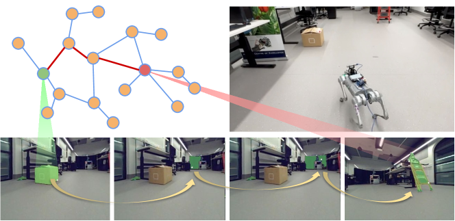
In this article, we introduce a novel strategy for robotic exploration in unknown environments using a semantic topometric map. As it will be presented, the semantic topometric map is generated by segmenting the grid map of the currently explored parts of the environment into regions, such as intersections, pathways, dead-ends, and unexplored frontiers, which constitute the structural semantics of an environment. The proposed exploration strategy leverages metric information of the frontier, such as distance and angle to the frontier, similar to existing frameworks, with the key difference being the additional utilization of structural semantic information, such as properties of the intersections leading to frontiers. The algorithm for generating semantic topometric mapping utilized by the proposed method is lightweight, resulting in the method's online execution being both rapid and computationally efficient. Moreover, the proposed framework can be applied to both structured and unstructured indoor and outdoor environments, which enhances the versatility of the proposed exploration algorithm. We validate our exploration strategy and demonstrate the utility of structural semantics in exploration in two complex indoor environments by utilizing a Turtlebot3 as the robotic agent. Compared to traditional frontier-based methods, our findings indicate that the proposed approach leads to faster exploration and requires less computation time.
Read more6/27/2024
0
RoboHop: Segment-based Topological Map Representation for Open-World Visual Navigation
Sourav Garg, Krishan Rana, Mehdi Hosseinzadeh, Lachlan Mares, Niko Sunderhauf, Feras Dayoub, Ian Reid
Mapping is crucial for spatial reasoning, planning and robot navigation. Existing approaches range from metric, which require precise geometry-based optimization, to purely topological, where image-as-node based graphs lack explicit object-level reasoning and interconnectivity. In this paper, we propose a novel topological representation of an environment based on image segments, which are semantically meaningful and open-vocabulary queryable, conferring several advantages over previous works based on pixel-level features. Unlike 3D scene graphs, we create a purely topological graph with segments as nodes, where edges are formed by a) associating segment-level descriptors between pairs of consecutive images and b) connecting neighboring segments within an image using their pixel centroids. This unveils a continuous sense of a place, defined by inter-image persistence of segments along with their intra-image neighbours. It further enables us to represent and update segment-level descriptors through neighborhood aggregation using graph convolution layers, which improves robot localization based on segment-level retrieval. Using real-world data, we show how our proposed map representation can be used to i) generate navigation plans in the form of hops over segments and ii) search for target objects using natural language queries describing spatial relations of objects. Furthermore, we quantitatively analyze data association at the segment level, which underpins inter-image connectivity during mapping and segment-level localization when revisiting the same place. Finally, we show preliminary trials on segment-level `hopping' based zero-shot real-world navigation. Project page with supplementary details: oravus.github.io/RoboHop/
Read more5/10/2024

0
FASTC: A Fast Attentional Framework for Semantic Traversability Classification Using Point Cloud
Yirui Chen, Pengjin Wei, Zhenhuan Liu, Bingchao Wang, Jie Yang, Wei Liu
Producing traversability maps and understanding the surroundings are crucial prerequisites for autonomous navigation. In this paper, we address the problem of traversability assessment using point clouds. We propose a novel pillar feature extraction module that utilizes PointNet to capture features from point clouds organized in vertical volume and a 2D encoder-decoder structure to conduct traversability classification instead of the widely used 3D convolutions. This results in less computational cost while even better performance is achieved at the same time. We then propose a new spatio-temporal attention module to fuse multi-frame information, which can properly handle the varying density problem of LIDAR point clouds, and this makes our module able to assess distant areas more accurately. Comprehensive experimental results on augmented Semantic KITTI and RELLIS-3D datasets show that our method is able to achieve superior performance over existing approaches both quantitatively and quantitatively.
Read more6/26/2024