Mixed-View Panorama Synthesis using Geospatially Guided Diffusion

0

Sign in to get full access
Overview
- This paper proposes a novel method for synthesizing mixed-view panoramic images using geospatially guided diffusion.
- The approach leverages geographic information to enhance the coherence and efficiency of panoramic image generation, producing high-quality results.
- The research builds upon recent advancements in panoramic image synthesis, such as TwinDiffusion, Taming Stable Diffusion, and GeoSpecific View Generation.
Plain English Explanation
The paper presents a new way to create panoramic images that combine different viewpoints. Instead of relying solely on image data, the approach also uses geographic information to guide the image synthesis process. This helps produce panoramas that are more coherent and efficient, meaning they look more natural and are created more quickly.
The method builds on recent advances in panoramic image generation, such as techniques that can generate 360-degree panoramas from text descriptions or that can create views of a location from different angles. By incorporating geographic data, the new approach is able to create panoramas that better reflect the actual layout and features of a real-world scene.
Technical Explanation
The key innovation of this work is the use of geospatially guided diffusion for mixed-view panorama synthesis. The authors leverage geographic information, such as terrain data and building footprints, to constrain and guide the diffusion process used to generate the panoramic images.
The diffusion model is conditioned on both image and geospatial inputs, allowing it to produce panoramas that are spatially coherent and aligned with the real-world geometry of the scene. This results in more realistic and accurate panoramic renderings compared to methods that only use visual data.
The authors demonstrate the effectiveness of their approach through extensive experiments, showing that it outperforms state-of-the-art panorama synthesis techniques like GeoSynth and Birds-Eye View to Street View on both quantitative and qualitative metrics.
Critical Analysis
The paper presents a well-designed and thorough study, with clear experimental setups and insightful analyses. However, the authors acknowledge several limitations and avenues for future work.
One key limitation is the reliance on high-quality geospatial data, which may not always be available, especially in less-developed regions. The authors suggest investigating ways to leverage more widely available geographic information, such as OpenStreetMap data.
Additionally, the current model is trained on a specific type of panoramic imagery (e.g., urban scenes). Extending the approach to handle a broader range of panorama types, such as natural landscapes or indoor environments, could further expand its applicability.
Overall, this research represents a promising step forward in panorama synthesis, demonstrating the value of incorporating geographic context to enhance the coherence and fidelity of the generated images.
Conclusion
This paper presents a novel method for synthesizing mixed-view panoramic images using geospatially guided diffusion. By leveraging geographic information, the approach is able to produce panoramas that are more coherent and efficient compared to existing techniques.
The research builds upon and advances the state of the art in panorama generation, incorporating insights from related work on panoramic image synthesis and view generation. The authors' extensive experiments validate the effectiveness of their approach, suggesting that geospatially guided diffusion could be a valuable tool for a wide range of applications, from urban planning to virtual tourism.
While the current implementation has some limitations, the paper points to exciting future directions, such as exploring the use of more widely available geographic data and expanding the model's capabilities to handle diverse panoramic scenes. Overall, this work represents an important contribution to the field of computer vision and image synthesis.
This summary was produced with help from an AI and may contain inaccuracies - check out the links to read the original source documents!
Related Papers
0
Mixed-View Panorama Synthesis using Geospatially Guided Diffusion
Zhexiao Xiong, Xin Xing, Scott Workman, Subash Khanal, Nathan Jacobs
We introduce the task of mixed-view panorama synthesis, where the goal is to synthesize a novel panorama given a small set of input panoramas and a satellite image of the area. This contrasts with previous work which only uses input panoramas (same-view synthesis), or an input satellite image (cross-view synthesis). We argue that the mixed-view setting is the most natural to support panorama synthesis for arbitrary locations worldwide. A critical challenge is that the spatial coverage of panoramas is uneven, with few panoramas available in many regions of the world. We introduce an approach that utilizes diffusion-based modeling and an attention-based architecture for extracting information from all available input imagery. Experimental results demonstrate the effectiveness of our proposed method. In particular, our model can handle scenarios when the available panoramas are sparse or far from the location of the panorama we are attempting to synthesize.
Read more7/16/2024

0
CrossViewDiff: A Cross-View Diffusion Model for Satellite-to-Street View Synthesis
Weijia Li, Jun He, Junyan Ye, Huaping Zhong, Zhimeng Zheng, Zilong Huang, Dahua Lin, Conghui He
Satellite-to-street view synthesis aims at generating a realistic street-view image from its corresponding satellite-view image. Although stable diffusion models have exhibit remarkable performance in a variety of image generation applications, their reliance on similar-view inputs to control the generated structure or texture restricts their application to the challenging cross-view synthesis task. In this work, we propose CrossViewDiff, a cross-view diffusion model for satellite-to-street view synthesis. To address the challenges posed by the large discrepancy across views, we design the satellite scene structure estimation and cross-view texture mapping modules to construct the structural and textural controls for street-view image synthesis. We further design a cross-view control guided denoising process that incorporates the above controls via an enhanced cross-view attention module. To achieve a more comprehensive evaluation of the synthesis results, we additionally design a GPT-based scoring method as a supplement to standard evaluation metrics. We also explore the effect of different data sources (e.g., text, maps, building heights, and multi-temporal satellite imagery) on this task. Results on three public cross-view datasets show that CrossViewDiff outperforms current state-of-the-art on both standard and GPT-based evaluation metrics, generating high-quality street-view panoramas with more realistic structures and textures across rural, suburban, and urban scenes. The code and models of this work will be released at https://opendatalab.github.io/CrossViewDiff/.
Read more8/28/2024

0
SkyDiffusion: Street-to-Satellite Image Synthesis with Diffusion Models and BEV Paradigm
Junyan Ye, Jun He, Weijia Li, Zhutao Lv, Jinhua Yu, Haote Yang, Conghui He
Street-to-satellite image synthesis focuses on generating realistic satellite images from corresponding ground street-view images while maintaining a consistent content layout, similar to looking down from the sky. The significant differences in perspectives create a substantial domain gap between the views, making this cross-view generation task particularly challenging. In this paper, we introduce SkyDiffusion, a novel cross-view generation method for synthesizing satellite images from street-view images, leveraging diffusion models and Bird's Eye View (BEV) paradigm. First, we design a Curved-BEV method to transform street-view images to the satellite view, reformulating the challenging cross-domain image synthesis task into a conditional generation problem. Curved-BEV also includes a Multi-to-One mapping strategy for leveraging multiple street-view images within the same satellite coverage area, effectively solving the occlusion issues in dense urban scenes. Next, we design a BEV-controlled diffusion model to generate satellite images consistent with the street-view content, which also incorporates a light manipulation module to make the lighting conditions of the synthesized satellite images more flexible. Experimental results demonstrate that SkyDiffusion outperforms state-of-the-art methods on both suburban (CVUSA & CVACT) and urban (VIGOR-Chicago) cross-view datasets, with an average SSIM increase of 13.96% and a FID reduction of 20.54%, achieving realistic and content-consistent satellite image generation. The code and models of this work will be released at https://opendatalab.github.io/skydiffusion
Read more8/20/2024
0
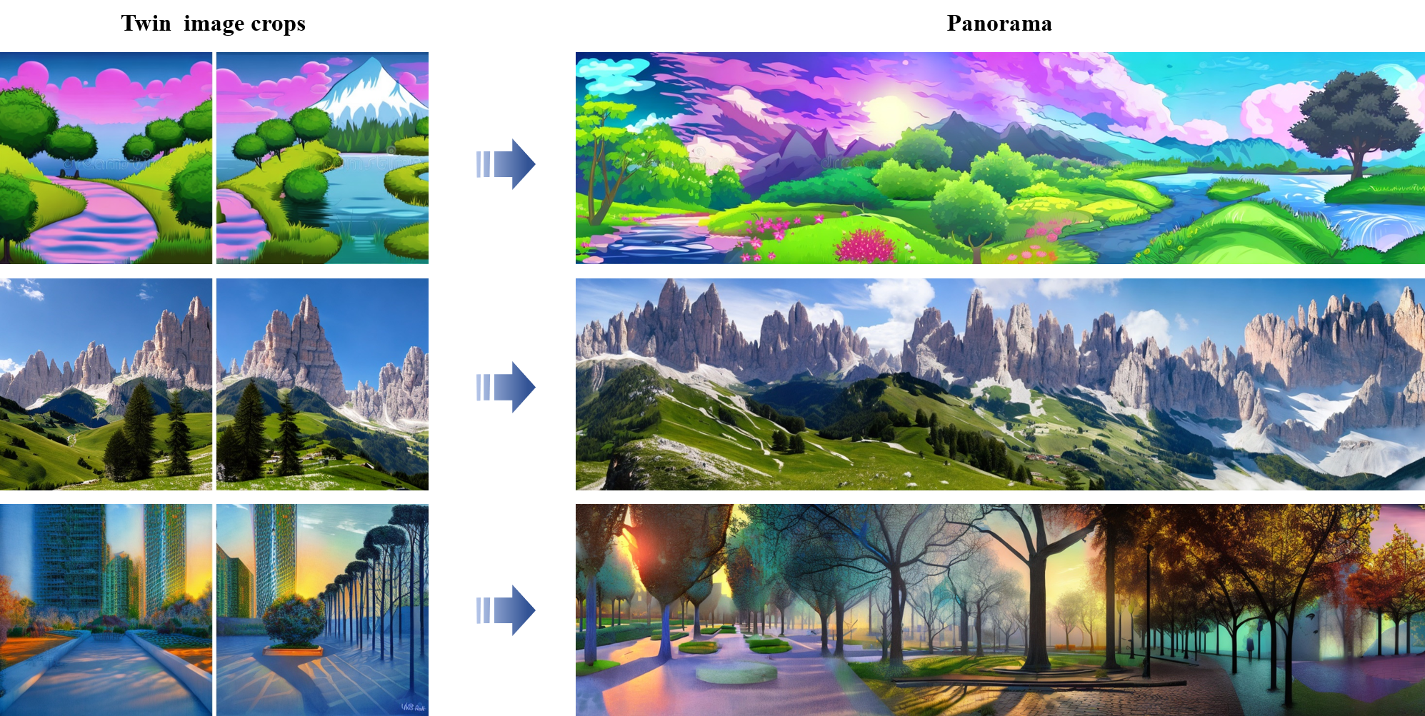
TwinDiffusion: Enhancing Coherence and Efficiency in Panoramic Image Generation with Diffusion Models
Teng Zhou, Yongchuan Tang
Diffusion models have emerged as effective tools for generating diverse and high-quality content. However, their capability in high-resolution image generation, particularly for panoramic images, still faces challenges such as visible seams and incoherent transitions. In this paper, we propose TwinDiffusion, an optimized framework designed to address these challenges through two key innovations: the Crop Fusion for quality enhancement and the Cross Sampling for efficiency optimization. We introduce a training-free optimizing stage to refine the similarity of adjacent image areas, as well as an interleaving sampling strategy to yield dynamic patches during the cropping process. A comprehensive evaluation is conducted to compare TwinDiffusion with the prior works, considering factors including coherence, fidelity, compatibility, and efficiency. The results demonstrate the superior performance of our approach in generating seamless and coherent panoramas, setting a new standard in quality and efficiency for panoramic image generation.
Read more7/9/2024