W-RIZZ: A Weakly-Supervised Framework for Relative Traversability Estimation in Mobile Robotics
2406.02822
0
0
Abstract
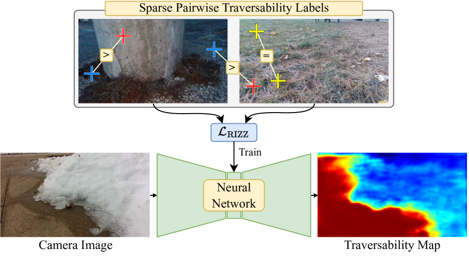
Successful deployment of mobile robots in unstructured domains requires an understanding of the environment and terrain to avoid hazardous areas, getting stuck, and colliding with obstacles. Traversability estimation--which predicts where in the environment a robot can travel--is one prominent approach that tackles this problem. Existing geometric methods may ignore important semantic considerations, while semantic segmentation approaches involve a tedious labeling process. Recent self-supervised methods reduce labeling tedium, but require additional data or models and tend to struggle to explicitly label untraversable areas. To address these limitations, we introduce a weakly-supervised method for relative traversability estimation. Our method involves manually annotating the relative traversability of a small number of point pairs, which significantly reduces labeling effort compared to traditional segmentation-based methods and avoids the limitations of self-supervised methods. We further improve the performance of our method through a novel cross-image labeling strategy and loss function. We demonstrate the viability and performance of our method through deployment on a mobile robot in outdoor environments.
Create account to get full access
Overview
- This paper introduces a new framework called W-RIZZ for estimating relative traversability in mobile robotics using a weakly-supervised approach.
- Traversability estimation is the task of determining how easily a robot can navigate through a given environment, which is crucial for path planning and control.
- W-RIZZ leverages weak supervision in the form of binary traversability labels to train a deep learning model for estimating relative traversability, without requiring expensive per-pixel annotations.
- The proposed framework is evaluated on both indoor and outdoor datasets, demonstrating improved performance compared to fully-supervised baselines.
Plain English Explanation
The paper presents a new system called W-RIZZ that helps robots navigate through different environments more effectively. Navigating complex terrains is a key challenge for mobile robots, as they need to determine how easy or difficult it will be to travel through different areas. This is known as "traversability estimation."
Traditionally, training robots to estimate traversability has required painstaking manual labeling of detailed per-pixel information about the environment. However, the W-RIZZ framework takes a different approach, using Learning Semantic Traversability from Egocentric Video and ForestTrav: Accurate and Efficient Deployable Forest Traversability Estimation to train a deep learning model with only coarse, high-level traversability labels. This "weakly-supervised" training process is more efficient and scalable than the traditional fully-supervised approach.
The W-RIZZ framework was evaluated on both indoor and outdoor datasets, and it demonstrated improved performance compared to fully-supervised baselines. This suggests that the weakly-supervised approach can effectively estimate traversability, enabling robots to more reliably navigate through complex environments.
Technical Explanation
The W-RIZZ framework uses a deep learning model to estimate relative traversability in mobile robotics. Unlike traditional fully-supervised approaches that require expensive per-pixel annotations, W-RIZZ leverages weak supervision in the form of binary traversability labels.
The core of the W-RIZZ system is a convolutional neural network that takes in an RGB image and outputs a traversability map, indicating how easy or difficult it would be for a robot to traverse different areas of the environment. The network is trained using a combination of binary traversability labels and a novel loss function that encourages the model to learn a relative ranking of traversability.
To evaluate the performance of W-RIZZ, the authors conducted experiments on both indoor and outdoor datasets. They compared the weakly-supervised W-RIZZ approach to fully-supervised baselines and found that W-RIZZ achieved superior results, demonstrating the effectiveness of the weakly-supervised training process.
The W-RIZZ framework also includes a traversability-aware path planning and control module that integrates the traversability estimates into the robot's navigation system, further enhancing its ability to navigate complex environments.
Critical Analysis
The W-RIZZ framework represents an innovative approach to traversability estimation that leverages self-supervised learning of physics-aware models to reduce the burden of manual data labeling. By using weak supervision in the form of binary traversability labels, the authors were able to train a deep learning model that can effectively estimate relative traversability, without requiring the detailed per-pixel annotations typically needed for this task.
One potential limitation of the W-RIZZ framework is that it may struggle to generalize to highly diverse or unfamiliar environments, as the training data is still relatively limited. The authors acknowledged this in the paper and suggested that future work could investigate ways to further improve the model's generalization capabilities.
Additionally, while the W-RIZZ framework demonstrated improved performance compared to fully-supervised baselines, it would be interesting to see how it compares to other state-of-the-art approaches for traversability estimation. The authors did not provide a comprehensive comparison to other recent methods, which could help contextualize the significance of their contributions.
Overall, the W-RIZZ framework represents a promising step forward in the field of traversability estimation for mobile robotics, with the potential to enable more reliable and efficient navigation in complex environments.
Conclusion
The W-RIZZ framework introduced in this paper offers a novel approach to estimating relative traversability in mobile robotics using a weakly-supervised deep learning model. By leveraging coarse, binary traversability labels instead of detailed per-pixel annotations, W-RIZZ reduces the burden of manual data labeling and demonstrates improved performance compared to fully-supervised baselines.
The successful application of W-RIZZ to both indoor and outdoor datasets suggests that this weakly-supervised approach can be a valuable tool for enabling mobile robots to navigate complex environments more effectively. As robots continue to play an increasingly important role in areas such as search and rescue, exploration, and transportation, technologies like W-RIZZ will be critical for improving their ability to safely and efficiently navigate through diverse terrain.
While the W-RIZZ framework represents a significant advancement in the field of traversability estimation, there are still opportunities for further research and development to enhance its generalization capabilities and integration with other robotic systems. Nevertheless, this work demonstrates the power of leveraging weak supervision to solve challenging problems in mobile robotics, and it is likely to inspire future innovations in this important area of study.
This summary was produced with help from an AI and may contain inaccuracies - check out the links to read the original source documents!
Related Papers

Learning Semantic Traversability with Egocentric Video and Automated Annotation Strategy
Yunho Kim, Jeong Hyun Lee, Choongin Lee, Juhyeok Mun, Donghoon Youm, Jeongsoo Park, Jemin Hwangbo
0
0
For reliable autonomous robot navigation in urban settings, the robot must have the ability to identify semantically traversable terrains in the image based on the semantic understanding of the scene. This reasoning ability is based on semantic traversability, which is frequently achieved using semantic segmentation models fine-tuned on the testing domain. This fine-tuning process often involves manual data collection with the target robot and annotation by human labelers which is prohibitively expensive and unscalable. In this work, we present an effective methodology for training a semantic traversability estimator using egocentric videos and an automated annotation process. Egocentric videos are collected from a camera mounted on a pedestrian's chest. The dataset for training the semantic traversability estimator is then automatically generated by extracting semantically traversable regions in each video frame using a recent foundation model in image segmentation and its prompting technique. Extensive experiments with videos taken across several countries and cities, covering diverse urban scenarios, demonstrate the high scalability and generalizability of the proposed annotation method. Furthermore, performance analysis and real-world deployment for autonomous robot navigation showcase that the trained semantic traversability estimator is highly accurate, able to handle diverse camera viewpoints, computationally light, and real-world applicable. The summary video is available at https://youtu.be/EUVoH-wA-lA.
6/6/2024
🎯
ForestTrav: Accurate, Efficient and Deployable Forest Traversability Estimation for Autonomous Ground Vehicles
Fabio Ruetz, Nicholas Lawrance, Emili Hern'andez, Paulo Borges, Thierry Peynot
0
0
Autonomous navigation in unstructured vegetated environments remains an open challenge. To successfully operate in these settings, ground vehicles must assess the traversability of the environment and determine which vegetation is pliable enough to push through. In this work, we propose a novel method that combines a high-fidelity and feature-rich 3D voxel representation while leveraging the structural context and sparseness of SCNN's to assess Traversability Estimation (TE) in densely vegetated environments. The proposed method is thoroughly evaluated on an accurately-labeled real-world data set that we provide to the community. It is shown to outperform state-of-the-art methods by a significant margin (0.59 vs. 0.39 MCC score at 0.1m voxel resolution) in challenging scenes and to generalize to unseen environments. In addition, the method is economical in the amount of training data and training time required: a model is trained in minutes on a desktop computer. We show that by exploiting the context of the environment, our method can use different feature combinations with only limited performance variations. For example, our approach can be used with lidar-only features, whilst still assessing complex vegetated environments accurately, which was not demonstrated previously in the literature in such environments. In addition, we propose an approach to assess a traversability estimator's sensitivity to information quality and show our method's sensitivity is low.
5/16/2024

Learning-based Traversability Costmap for Autonomous Off-road Navigation
Qiumin Zhu, Zhen Sun, Songpengcheng Xia, Guoqing Liu, Kehui Ma, Ling Pei, Zheng Gong
0
0
Traversability estimation in off-road terrains is an essential procedure for autonomous navigation. However, creating reliable labels for complex interactions between the robot and the surface is still a challenging problem in learning-based costmap generation. To address this, we propose a method that predicts traversability costmaps by leveraging both visual and geometric information of the environment. To quantify the surface properties like roughness and bumpiness, we introduce a novel way of risk-aware labelling with proprioceptive information for network training. We validate our method in costmap prediction and navigation tasks for complex off-road scenarios. Our results demonstrate that our costmap prediction method excels in terms of average accuracy and MSE. The navigation results indicate that using our learned costmaps leads to safer and smoother driving, outperforming previous methods in terms of the highest success rate, lowest normalized trajectory length, lowest time cost, and highest mean stability across two scenarios.
6/13/2024
📉
Wild Visual Navigation: Fast Traversability Learning via Pre-Trained Models and Online Self-Supervision
Mat'ias Mattamala, Jonas Frey, Piotr Libera, Nived Chebrolu, Georg Martius, Cesar Cadena, Marco Hutter, Maurice Fallon
0
0
Natural environments such as forests and grasslands are challenging for robotic navigation because of the false perception of rigid obstacles from high grass, twigs, or bushes. In this work, we present Wild Visual Navigation (WVN), an online self-supervised learning system for visual traversability estimation. The system is able to continuously adapt from a short human demonstration in the field, only using onboard sensing and computing. One of the key ideas to achieve this is the use of high-dimensional features from pre-trained self-supervised models, which implicitly encode semantic information that massively simplifies the learning task. Further, the development of an online scheme for supervision generator enables concurrent training and inference of the learned model in the wild. We demonstrate our approach through diverse real-world deployments in forests, parks, and grasslands. Our system is able to bootstrap the traversable terrain segmentation in less than 5 min of in-field training time, enabling the robot to navigate in complex, previously unseen outdoor terrains. Code: https://bit.ly/498b0CV - Project page:https://bit.ly/3M6nMHH
4/11/2024